Fronalpstock (Glarus)
| Fronalpstock | ||
|---|---|---|
|
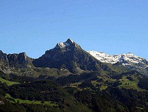
The Fronalpstock (GL) from the Linthebene seen from |
||
| height | 2123 m above sea level M. | |
| location | Canton of Glarus , Switzerland | |
| Mountains | Glarus Alps | |
| Dominance | 1.85 km → Siwellen | |
| Notch height | 268 m ↓ Fronalp Pass | |
| Coordinates | 726 778 / 214383 | |
|
|
||
| Normal way | Alpine mountain trail from Fronalppass T4 | |
|
South slope |
||
Fronalpstock is a 2123 m above sea level. M. high mountain in the canton of Glarus east of Netstal on the border between Mollis and Ennenda , today Glarus Nord and Glarus . He stands a little upstream between the 2440 m above sea level. M. high Ruchen in Mürtschenstock and Schwarzstöckli ( 2383 m above sea level. M. ). It has a distinctive pyramid-shaped rock structure directly above the Fronalp.
Sure-footed hikers can reach the summit from the Fronalp Pass in around 45 to 60 minutes. The path leads through a chimney secured with chains ( SAC hiking scale: T4 ). From the top of the mountain there is a panoramic view down into the Linth valley and over the northern part of the canton.
On the Fronalp west of the summit there is a mountain inn and the two ski lifts of the Schilt ski area . The area is also used on ski tours in winter .
There is a mountain of the same name in the Schwyz Alps in the neighboring canton of Schwyz .
Web links
- Fronalpstock, 2124 m above sea level on bergtour.ch
Individual evidence
- ↑ a b maps from swisstopo
- ↑ The Fronalpstock mountain inn burned down completely in November 2019, cf. Mountain restaurant burned down. In: Swiss farmer. November 10, 2019, accessed November 11, 2019 .


