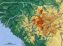
Fouta Djallon
The Fouta Djallon [ futadʒaˈlɔ̃ ], German Futa Dschalon (alternative spellings : Futa Jalon, Futa Djalon, Fouta Djalon ) is a mountainous country in Guinea ( West Africa ). It is also one of the four unofficial, geographically defined regions in the country. An alternative name is Central Guinea ( French Moyenne Guinée , zone du Fouta Djalon ). The center of the region is Labé .
geography
It is located in the center of the state on the Upper Guinea threshold . The mountainous area has an area of about 47,000 km² and is up to 1,538 m above sea level. The landscape, which is largely untouched due to the slow modernization, is determined by the mountains of Fouta Djallon with its numerous table mountains. It is characterized by the vegetation of the tropical dry forest . The locals use the land for growing crops, grain and corn. Animal breeding is limited to goats and cattle.
The Fouta Djallon region and the capital Labé are as good as not developed for tourism. The main reason for this is the poor infrastructure that is standard in all of Guinea. Electricity and running water are rare in the region.
population
The area is mainly inhabited by the Fulbe (Peul). The Ful dialect of Fouta Djallon is the national language in Guinea. In contrast to most Fulbe, the Fulbe of Fouta Djallon are sedentary.
Hydrology
The mountains of Fouta Djallon are the " water tower of West Africa". The rivers Senegal ( Bafing ) and Gambia have their source here and drain to the north. To the west it is the Rio Corubal via Guinea-Bissau and the Konkoure to the southwest. To the south, over Sierra Leone , it is the Little Scarcies and to the east the tributaries of the Niger , like the Tinkisso, flow . Senegal in particular benefits from the high rainfall in the mountainous region, as it hardly gets any additional water as it continues into the Sahel zone outside of the rainy season.
history
The name Fouta Djallon comes from the Dialonke , the original inhabitants of the area. From around 1700 to 1934 there existed the empire of the same name, founded by the Fulbe of Fouta Djallon , which was conquered by Karamoko Alfa and Ibrahima Sori in a jihad. Timbo, which is 42 kilometers northeast of Mamou, was the seat of the emir, which was occupied by the French in 1896.
gallery
See also
Web links
- Article Fouta Djallon in Encyclopedia Britannica (English)
- Fouta Djalon Bibliography (French)
- about the historical state Fouta Djallon (English)
Individual evidence
- ^ Fouta Djallon Highland Water Atlas - The Water Tower of West Africa
- ↑ Article Fouta Djallon in Encyclopedia Britannica
Coordinates: 11 ° 19 ′ N , 12 ° 17 ′ W


