Gürzenich Bach
| Gürzenich Bach | ||
|
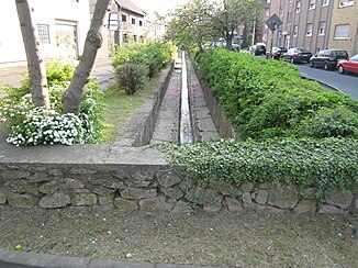
The brook in Schillingsstrasse |
||
| Data | ||
| Water code | DE : 282384 | |
| location | North Rhine-Westphalia , Germany | |
| River system | Rhine | |
| Drain over | Lendersdorfer Mühlenteich → Rur → Maas → Hollands Diep → North Sea | |
| River basin district | Meuse | |
| source | Northwest of Gey 50 ° 45 ′ 49 ″ N , 6 ° 23 ′ 48 ″ E |
|
| Source height | 225 m above sea level NN | |
| muzzle | North-east of Gürzenich in the Lendersdorfer Mühlenteich Coordinates: 50 ° 48 '29 " N , 6 ° 27' 27" E 50 ° 48 '29 " N , 6 ° 27' 27" E |
|
| Mouth height | 120 m above sea level NN | |
| Height difference | 105 m | |
| Bottom slope | 14 ‰ | |
| length | 7.6 km | |
| Catchment area | 11.778 km² | |
The Gürzenich Bach is a 7.6 km long orographic left tributary of the Lendersdorfer Mühlenteich in Düren , North Rhine-Westphalia , Germany .
geography
The brook rises on the northeastern roof of the Eifel about 2 km northwest of Gey in the municipality of Hürtgenwald . The source is at an altitude of 225 m above sea level. NN . Flowing to the northeast, the stream reaches the area of the Gürzenich Bundeswehr Depot after about 700 m . Here the stream is first directed to the north and then in the northern area along a road through the depot. After leaving the Bundeswehr area, the stream continues to flow in a north-easterly direction along a dirt road. After reaching the Hubertushof, the Gürzenich Bach crosses under the Schevenhüttener Strasse and then flows along the road to Gürzenich.
In the local area of Gürzenich the brook follows the course of the Schillingstraße. In the southwestern section, the stream flows largely underground. The Trierbach flows here on the right . In the northeast section, the stream runs in the middle of the road in an artificial stream bed. From the confluence of the Neue Aue road , the stream flows more in a northerly direction, then crosses under the federal road 264 and the parallel railway line . Then the run bends to the east to flow around the sports field and archery range. Running parallel to Mirweilerweg and Dr.-Christian-Seybold-Straße, the stream reaches its confluence with the Lendersdorf mill pond . From this some water is knocked off and led to the Rur as Gürzenich Bach .
With a height difference of 105 m, the mean bed gradient of the creek is 13.8 ‰. The 11.778 km² catchment area is drained to the North Sea via Lendersdorfer Mühlenteich, Rur and Maas .
Others
In the locality of Gürzenich, the stream with its typical village, street-center course is entered as Trierbach in the list of monuments of the city of Düren.
Individual evidence
- ↑ a b German basic map 1: 5000
- ↑ a b Topographical Information Management, Cologne District Government, Department GEObasis NRW ( Notes )
- ↑ Monuments in the city of Düren 6-9
