
Gallows drain


The Galgenablass is a water crossing with a culvert in the Augsburg city forest . It is a protected architectural monument in Augsburg-Haunstetten-Siebenbrunn and was included in the UNESCO World Heritage List on July 6, 2019 as part of the " Augsburg Water Management System " .
location
The Galgenablass is located in the Siebentischwald near Siebenbrunner Straße, about halfway between Siebenbrunn and the Hochablass . It cannot be reached directly by public transport or by car, but it is easy to visit on foot or by bike.
history
The network of Augsburg's canals and streams , which represent the “lifelines” of the city 's historic water management , has been under constant renovation for centuries. It contained a number of water crossings early on. Many of them have now disappeared, others have been added. The more than 500-year-old gallows drain is one of the oldest and still existing water crossings.
The water crossing
While most of the streams and canals in the Augsburg city forest flow from south to north following the natural gradient, the 2.5 km long border trench runs from west to east. Until 1806 it marked the border between the Free Imperial City of Augsburg and the Electorate of Bavaria . The border ditch has crossed the 4.5 km long Siebenbrunn stream since around 1500 . It was originally led at this point in a wooden bridge over the Siebenbrunn brook.
To regulate the amount of water in Siebenbrunner Bach there was also a crossroads in this water to the 19th century contactor whose slide was suspended from a construction that a gallows possible. In construction, structures that consist of a column and a cantilever are often referred to as gallows. Hence the hydraulic structure got its name "Galgenablass". It has nothing to do with a place of execution .
Separation of industrial and drinking water until 1840
The water crossing separated service and drinking water . However, the hydrotechnical situation has changed significantly over the course of history.
The Siebenbrunn brook was originally a spring water brook with several springs. Since the connection piece Brunnengraben has existed (this date is not yet known), the Siebenbrunn Bach has been one of the tributaries of the Brunnenbach . The names of the streams often changed over time. Until the first half of the 20th century, the Siebenbrunner Bach is also said to have been called the Brunnenbach. The water from the Brunnenbach was used from 1416 to 1840 in the waterworks at the Red Gate to feed the wells in Augsburg.
The type of water supply to the border trench was probably changed several times. It is said to have had its own spring discharge in the area of today's “Volkssiedlung” ( Augsburg-Haunstetten ) (without a date) . A map from 1790, on the other hand, shows that at that time it was fed with Lech water over a distance of many kilometers from the Lochbach near its tapping point . At that time there was probably another water crossing at the point where the border ditch is now fed by the Brunnenbach. The border ditch originally flowed into the Lech immediately before the Hochablass .
The area south of the Galgenablass originally belonged to the municipality of Mering east of the Lech and was therefore called "Meringer Au". In 1804 it was opened for cultivation. This resulted in the independent municipality of Meringerau, consisting of farmhouses, five manors with manor houses , a restaurant and an elementary school .
Development since giving up separation

Since the Brunnenbach was no longer used as drinking water, there was no longer any hygienic reason to keep spring streams and Lech canals separate. When the Lech was shifted to the east, the water table fell and a number of springs dried up. Lech water has now been supplied to several former source streams to compensate for their drying up.
A first attempt to forward the Siebenbrunner Bach Lech water, was the 1848 north of the gallows indulgences dug Empire channel . The Lechanstich immediately south of the Hochablasse , which was supposed to feed the Reich Canal, worked poorly as such and the canal was mostly dry. That is why this Lechanstich was given up and instead the water of the border ditch - together with the spring stream Ziegelmoorbächlein , which has now dried up - was channeled into the Siebenbrunner Bach via the Reich Canal.
In order to increase the amount of water in the upper reaches of the Siebenbrunn brook, Lech water was supplied to it from the south. Today the Siebenbrunn Bach is mainly fed via the Lochbach via the Neuer Graben , Bayerbach , Gießer and Alter Floßgraben canals . So today it no longer has clear spring water, but cloudy Lech water. The Grenzgraben experienced a reverse process: Today it is no longer fed by the Lochbach, but by the Brunnenbach, which means that it now has clear spring water again.
Industry at the Siebenbrunn Bach; Conversion with culvert

The Lechwasser-reinforced Siebenbrunn brook, which had a volume flow of 0.75 m³ / s around 1867 , was now to serve to develop the agricultural and forestry village of Meringerau (which was also called Siebenbrunn) on an industrial scale.
The cutlery dealer Albrecht Höppl acquired the right to use water as well as land in Meringerau and built a weaving mill there from 1866–1868 that used the water power of the Siebenbrunn brook via a turbine system, the mechanical weaving mill Siebenbrunn. In addition to the turbine house, which was built over the Siebenbrunn brook, there was also a small water tower . The weaving mill in turn became the basis for a workers' colony from which the Siebenbrunn Lower Village emerged. The canteen of the residential colony was later converted into the excursion restaurant "To the seven wells".
In order to increase the energy yield at the Siebenbrunn Bach, it was deepened in 1870. The gallows outlet was rebuilt so that the border ditch has not crossed the Siebenbrunn Bach on a bridge since then, but has crossed under it in a culvert. The contactor with its gallows a few meters downstream of the culvert was removed. However, the water crossing kept its old name. Since then, it has been structurally unchanged in principle.
In order to protect the weaving mill's turbine works from flooding, part of the Siebenbrunn brook was diverted towards the Ziegelmoorbächlein if necessary. In 1885 the water volume of the Siebenbrunn brook was doubled to 1.5 m³ / s and the brook gradient at the turbine house was increased to 1.8 meters.
End of industry and settlement
Meringerau was incorporated into Augsburg in 1910 under the name Siebenbrunn.
In 1937 the Siebenbrunn mechanical weaving mill was shut down. The Haunstetter aircraft manufacturer Messerschmitt AG then used the factory building as a production facility until the end of the Second World War. After that there were other re-uses.
Since the 1930s, the city of Augsburg has systematically acquired land in Siebenbrunn in order to demolish the buildings on it and renaturalize the areas for drinking water protection. The Augsburg city forest has been an official drinking water protection area since 1962 . From 1977 to 1980, the entire remaining Siebenbrunn Unterdorf including the former factory was demolished for reasons of drinking water protection and the areas were then reforested.
Indulgence on the Upper Anger

Since the construction of the Stempflesees lake (1924) and the Augsburg Zoo (1937) there has been a completely new hydrotechnical solution to the north, i.e. downstream, of the gallows outlet. Where the Reich Canal previously flowed into the Siebenbrunn Bach, there is now another water crossing with a double culvert at the outlet on the Obere Anger . The Zigeunerbach (clear spring water from the Brunnenbach) coming from Stempflesee is led through this culvert under the Siebenbrunn Bach.
Most of the water in the Reich Canal bends to the right at the outlet on the Obere Anger and is channeled into the zoo together with the Gypsy stream. There it flows in streams and ponds through various animal enclosures. It then leaves the zoo and feeds the Spitalbach .
A connection between the Reichskanal and the Siebenbrunner Bach at the outlet at the Obere Anger enables a demand-dependent exchange of water in both directions. The Siebenbrunner Bach flows further through the Siebentischpark and ends today, when it partly feeds the Spitalbach and partly flows over the Brunnenbach into the Brunnenbach.
Thus, in the 20th century, there was a new water-hygienic reason for keeping the two streams separate, in a way the opposite of the reason that existed until 1840. Because now the Siebenbrunn Bach is the one with the poorer quality Lech water, and the Grenzgraben water is used in the zoo, for which its water quality is important.
tourism
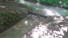

The Galgenablass is rather unspectacular as a tourist object, since both watercourses are only small streams and the culvert runs underground. The history and functionality of the water crossing is explained on an information board. Guided tours can be booked through the environmental station Augsburg.
Above ground it can be seen that part of the Siebenbrunn Brook is diverted to the right if necessary (when the water level is higher). From the left, the border ditch seems to end at the Siebenbrunn Bach; in fact, however, a culvert grate diverts its water vertically down into the culvert, where it crosses under the Siebenbrunn brook, emerges again on the right side of the Siebenbrunn brook and continues its way as a border ditch. If the culvert grid becomes clogged or the boundary ditch supplies more water than the culvert can hold, water from the boundary ditch is drained into the Siebenbrunn brook via a sill .
At the gallows outlet there are also several small bridges, a small wooden hut, the "Galgenhütte", and a small meadow, the "Galgenwiese".
Not far from the gallows outlet you can still see the empty shot or overflow of the turbine works of the demolished weaving mill on the Siebenbrunn stream. Remnants of a chestnut avenue, a wayside cross, a playground and an information board still bear witness to the earlier settlement.
Wrong representations
As part of the application by the city of Augsburg for recognition as a UNESCO World Heritage Site, the gallows drain was misrepresented in various writings, especially in the nomination dossier . The dossier repeatedly claims that the border ditch supplied drinking water and that the purpose of the gallows drain was to separate the drinking water of the border ditch from the water used by the Siebenbrunn brook. The authors apparently did not know that the Siebenbrunn brook used to be a spring brook, which supplied drinking water as a tributary of the Brunnen brook until 1840, and that it was only converted into a service water canal after the end of its drinking water use, while the Grenzgraben was historically partly spring water and partly Lech water led, but never drinking water.
Some of these mistakes are repeated in the city's current publications to this day.
Web links
- What hangs on the "Galgenablass" , magazine of Stadtwerke Augsburg , December 11, 2018
- Galgenablass (culvert) on the website of the World Heritage Office of the City of Augsburg (caution: contains several misrepresentations)
Individual evidence
- ^ Hydraulic Engineering and Hydropower, Drinking Water and Decorative Fountains in Augsburg. In: whc.unesco.org. UNESCO World Heritage Center, accessed May 22, 2018 .
- ↑ a b Galgenablass (culvert) - The Augsburg water management system. In: wassersystem-augsburg.de. Retrieved November 9, 2020 .
- ↑ a b :: WasSerLeben - Nature in Augsburg: Grenzgraben ::. www.wasserleben-augsburg.de, accessed on November 11, 2020 .
- ↑ a b :: WasSerLeben - Nature in Augsburg: Siebenbrunner Bach ::. www.wasserleben-augsburg.de, accessed on November 11, 2020 .
- ↑ :: WasSerLeben - Nature in Augsburg: Brunnengraben ::. www.wasserleben-augsburg.de, accessed on November 13, 2020 .
- ↑ Our brooks and canals (PDF), p. 28, "Siebenbrunner Bach" profile
- ^ Map from 1790, shown in: Martin Kluger : Historische Wasserwirtschaft und Wasserkunst in Augsburg. Canal landscape, water towers, fountain art and water power. 2nd Edition. Context Verlag, Augsburg 2012, ISBN 978-3-939645-50-4 , ill. Pp. 18-19
- ↑ Historischer Verein für Schwaben: Journal of the Historischer Verein für Schwaben . Seitz, 1980, p. 166 ( books.google.de ).
- ↑ Franz Joseph Kollmann: The waterworks of Augsburg: Description of all hydrotechnical institutions in the city, the Lech and Wertachablass, the canals, wells, etc. with the most important building regulations: In addition to a view of the Lech drain and hydrographic map of Augsburg and its surroundings . Rieger, 1850, p. 149 ( books.google.de ).
- ↑ :: WasSerLeben - Nature in Augsburg: Reichskanal ::. www.wasserleben-augsburg.de, accessed on November 9, 2020 .
- ↑ :: WasSerLeben - Nature in Augsburg: Ziegelmoorbächlein ::. www.wasserleben-augsburg.de, accessed on November 9, 2020 .
- ↑ :: WasSerLeben - Nature in Augsburg: Lochbach ::. www.wasserleben-augsburg.de, accessed on November 9, 2020 .
- ↑ a b c d Franz Häußler: Industry in the middle of the green. Augsburger Allgemeine, May 28, 2010, accessed on November 13, 2020 .
- ^ Augsburger Allgemeine: Meringerau became Siebenbrunn. In: augsburger-allgemeine.de. Augsburger Allgemeine, accessed on November 20, 2020 .
- ↑ :: WasSerLeben - Nature in Augsburg: Zigeunerbach ::. www.wasserleben-augsburg.de, accessed on November 9, 2020 .
- ^ Nomination letter of the city of Augsburg (PDF), p. 29
- ↑ :: WasSerLeben - Nature in Augsburg: Spitalbach ::. www.wasserleben-augsburg.de, accessed on November 9, 2020 .
- ↑ Streams and canals in the Augsburg city forest .... In: stadtzeitung.de. Retrieved November 9, 2020 .
- ↑ The Water Management of Augsburg (PDF, 46 MB)