Brunnenbach (Lochbach)
| Brunnenbach | ||
| Data | ||
| location | Bavaria , Germany | |
| River system | Lech | |
| Drain over | Lochbach → Lech → Danube → Black Sea | |
| source | in the Augsburg city forest 48 ° 17 ′ 22 ″ N , 10 ° 54 ′ 42 ″ E |
|
| muzzle | Right inflow of the Lochbach at the Haunstetter Straße stop in Augsburg Coordinates: 48 ° 21 ′ 16 ″ N , 10 ° 54 ′ 10 ″ E 48 ° 21 ′ 16 ″ N , 10 ° 54 ′ 10 ″ E
|
|
| length | 10 km | |
| Big cities | augsburg | |
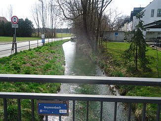
The Brunnenbach is part of Augsburg's historical water management . In earlier centuries, at least since 1412, it supplied the city of Augsburg with drinking water . It rises from several sources in the Lech Auwald south of the city. In the post-glacial alluvial gravel of the Lechfeld , powerful groundwater currents push northwards, which in many places feed sources from which streams flow northwards. These source streams are traditionally referred to here as "pourers".
A brook with the combined water of several of these springs, whose water was pure enough to supply the growing city, was called Brunnenbach. The brook was led into the city and supplied many of the public wells and private water connections in Augsburg via a waterworks and water towers .
Today no more drinking water is taken from the Brunnenbach. It still flows through the Augsburg city forest, but now flows into the Lech Canal Lochbach in front of the Red Gate. This then runs through the Lechviertel and unites in the north of the city with the other Lech canals before it flows back into the Lech.
course
The Brunnenbachstein
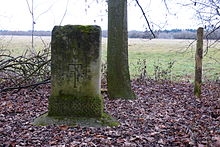
At the southernmost source of the Brunnenbach, at the height of today's city of Königsbrunn , the Brunnenbachstein was erected in 1603, a weathered limestone monument that is 85 cm high today. On both sides it bears the inscription 1603 - origin of the brunenbach and a patriarchal cross mutilated on one side in the lower beam , the coat of arms of the former owner of the land, St. Ulrich and Afra monastery . The imperial city of Augsburg secured the valuable water of the Brunnenbach through contracts with the convent in 1556 and 1617. The shifting of the Lech to the east caused the spring to dry up at the point marked with the stone, today the Brunnenbach feeds itself from springs further north. A copy of the Brunnenbachstein stands on the dry spring basin, while the original is in the Königsbrunn Lechfeld Museum.
In the Augsburg city forest
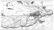
The Brunnenbach follows the slope of about three per thousand to the north and flows in the Augsburg city forest between the Lechkanal Lochbach in the west and other streams and the Lech itself in the east. At the height of Haunstetten two shorter streams flow to it from the right, the Jägerbach and the Ochsenbach . Then the Brunnenbach flows through the Siebentischwald and the Siebentischanlage , where the Gypsy stream slides off to the right. This feeds the Stempflesee, which was created in the 20th century . The Brunnenbach, on the other hand, runs further north and today flows into the Lochbach at the level of the Protestant cemetery , shortly before crossing under the Munich – Augsburg railway line .
In the city
In the section in front of the Red Gate , the Brunnenbach shares a canal bed with the Lochbach, but its water used to be meticulously separated from the Lochbach water by a wooden partition. Only the Brunnenbach water reached the waterworks at the Red Gate , which was used from 1416 to 1879 , where a complex pump system driven by running water, the heart of Augsburg's water art , raised it to three water towers. From the water towers, the water then ran through a pipe network system to the Augsburg city fountain and some connected buildings. Brunnenbach water also fed the magnificent Augsburg fountains .
allegory
A figure at the Augustusbrunnen in Augsburg personifies the Brunnenbach. Like the three other Augsburg city rivers Lech, Wertach and Singold , it occupies one of the four corners of the fountain. The Brunnenbach is represented with a spring nymph. She is leaning on a jug with her right hand, and holding a cornucopia with fruit on her left.
Which of the figures is assigned to the Brunnenbach is controversial in literature. Older literature ( Jürgen Bartel ) interprets a male figure with a wreath of oak leaves, a net and a fish as the river god of the Brunnenbach. More recent literature (including Dorothea Diemer and Martin Kluger ), on the other hand, interprets a female figure with a cornucopia and jug as the river goddess of the Brunnenbach.
In the Golden Hall of the Augsburg town hall , a mural by the Augsburg artist Hans Rottenhammer shows the Brunnenbach allegorically above one of the portals. The artist does not depict the Brunnenbach with a female river deity, but with a young man.
literature
- Wilhelm Ruckdeschl with the collaboration of Klaus Luther: Technical monuments in Augsburg . Brigitte Settele Verlag, Augsburg 1984.
- Wilhelm Ruckdeschl: Industrial culture in Augsburg . Brigitte Settele Verlag, Augsburg 2004, ISBN 3-932939-44-1 .
Web links
- Rivers in Augsburg - Background
- Overview map of all Augsburg streams and canals with additional detailed maps (PDF)
Individual evidence
- ↑ Landschaftspflegeverband Stadt Augsburg eV: Bach profile of Brunnenbach
- ^ Martin Kluger: Hydraulic engineering and hydropower, drinking water and fountain art in Augsburg. 1st edition. Context Verlag, Augsburg 2013, ISBN 978-3-939645-72-6 , p. 13 .
- ^ Martin Kluger: Hydraulic engineering and hydropower, drinking water and fountain art in Augsburg . 1st edition. Context Verlag, Augsburg 2013, ISBN 978-3-939645-72-6 , p. 76 .


