Strada Statale 249 Gardesana Orientale
| Strada statale SS249 in Italy | |
| Gardesana Orientale | |

|
|
| map | |
| Basic data | |
| Operator: |
Province of Mantua Region of Veneto Autonomous Province of Trento |
| Start of the street: | former Strada Statale 10 near Castel d'Ario ( 45 ° 12 ′ N , 10 ° 57 ′ E ) |
| End of street: |
Strada Statale 45 to near Arco ( 45 ° 55 ′ N , 10 ° 53 ′ E ) |
| Overall length: | 101.130 km |
|
Regions : |
|
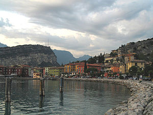
| Torbole in the evening light | |
|
Course of the road
|
|
The Italian state road SS 249 Gardesana Orientale is part of the Gardesana, a relatively wide and free coastal road on the east side of Lake Garda , completed in 1926 , which leaves the lake in the south at Peschiera and continues to Susano (municipality of Castel d'Ario ).
The Autonomous Province of Trento has been since 1998, and since 2001 the regions of Veneto and Lombardy have also been responsible for the administration of the sections of the state road on their territory. In Veneto the road is now called SR 249 ( strada regional 249 Gardesana Orientale ), in Lombardy as SP 249 ( strada provinciale ex SS 249 Gardesana Orientale ), while in the province of Trento it is continued as SS 249 Gardesana Orientale.
The eastern shore road begins in the north in Arco and reaches the lake at Torbole . To the east, separated by Monte Brione , is Torbole, which has become a surfer's paradise due to the periodic winds, the Paesano (mountain wind) and the Ora (south wind). The place has an interesting historical center and one of the most beautiful promenades on Lake Garda.
On the first part, the road is characterized by slopes formed from stone slabs, then by the massif of Monte Baldo, which slopes uniformly towards the lake . Malcesine , which is still associated with Goethe's Italian journey, spreads out at its foot . The elegant place is known for its picturesque cityscape with the old port as well as for the Scaliger Castle and the Palazzo dei Capitani.
From here there are magnificent views over to the west side with the precipices of the mountain groups of Tremalzo , Caplone and Pizzocolo . The view from the northernmost summit of Monte Baldo , the 2079 m high Monte Altissimo di Nago , is even more comprehensive towards the Alps . The highest of the peaks is the Cima Valdritta with 2218 m . The Funivia Malcesine cable car takes you from Malcesine up to Tratto Spino. Because of the extremely diverse flora, this mountain region has been given the nickname "Hortus Europae".
From Torri del Benaco, at the beginning of a headland in the center of the "Riviera degli Olivi", the lake widens to the south. From here one perceives the lake to the north as a mountain lake and to the south as the body of water of the northern Italian plain. The importance of Torri del Benaco goes back to Roman times. The old Castrum Turrium was for a time the main town of the Gardesana di terra e dell'acqua, the 18 municipalities of the eastern Lake Garda. The Romans once built defensive buildings here, and a castle had been built in Berengar's time . The castle of the last Scaliger , Antonio della Scala, from 1383, is still standing today .
Further south, the Gardesana finally reaches the main town of Garda , which gave the lake its name, and Bardolino , home of the red wine of the same name . The southeastern part of the shore, which swings out from Punta San Vigilio via Lazise to Sirmione , is particularly sunny.
The "Baia delle Sirene" (Bay of the Sirens ) north of Punta San Vigilio has one of the most beautiful beaches on Lake Garda. At the southern tip of the peninsula, Agostino di Brenzone, a patrician from Verona, had a fisherman's inn converted into a guest house in 1540, a garden laid out and a villa built. It is sometimes said that the complex, which blends in beautifully with the shore landscape, was the model for the painter Arnold Böcklin's painting Die Toteninsel, which was painted at the end of the 19th century . However, it has not yet been proven that Böcklin ever visited this place or knew it from descriptions.
The bay of Garda with the remains of the “Rocca di Garda”, reminiscent of historical highlights, is one of the most popular places. From the lake promenade of Garda the view goes over the wide expanse of water of the southern Lake Garda, into which you can see the Sirmione peninsula protruding far.
See also
literature
- Hermann Frass, Franz H. Riedl: Lake Garda. Illustrated book. Verlag R. Manfrini, Rovereto / Bozen 1967, ISBN 88-7024-063-0 .


