Hospitable
| Hospitable | ||
|---|---|---|
|
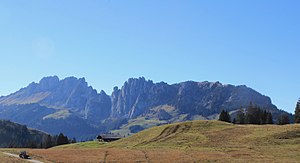
Gastlosen (right) and Sattelspitzen (left), from Jaunpass from |
||
| height | 2252 m above sea level M. | |
| location | Cantons of Friborg , Bern and Vaud , Switzerland | |
| Mountains | Freiburg Pre-Alps | |
| Dominance | 3.84 km → Dent de Brenleire | |
| Notch height | 848 m ↓ Jeu de Quilles | |
| Coordinates | 587945 / 159 220 | |
|
|
||
| rock | Malmkalk | |
The Gastlosen ( Freiburger Patois ) are a chain of striking limestone cliffs in the foothills of the Alps on the border between the Swiss cantons of Friborg , Bern and Vaud . They are tellingly advertised as the “Saanenland Dolomites”. Only the mountain peaks south of Jaun located in the extreme northeast of the chain are referred to as guestless in the narrower sense .
geography
The Gastlose chain extends in the Freiburg Pre-Alps over a length of around 15 km and is oriented towards the southwest-northeast. In the south-west the Ciernes Picat gorge forms the demarcation, while in the northeast the Jäunli gorge (source stream of the Jaunbach ) separates the Gastlosen from the heights north of the Jaunpass . The entire chain consists of 61 peaks and sub-peaks. A distinction is made between the following groups or main peaks from northeast to southwest:
- Gastlosen with the Marchzähnen ( 1996 m above sea level ) as the highest points, followed by the Oberbergpass
- Sattelspitzen with the Rüdigenspitze (2124 m above sea level), a little next door the Gross Turm (2123 m above sea level), followed by the pass gap in Wolfs Ort ( 1915 m )
- Wandflue (2133 m above sea level), Zuckerspitz (2133 m above sea level), Dent de Ruth (2236 m above sea level) and Dent de Savigny (at 2252 m above sea level, the highest point in the entire chain) followed by the Porte de Savigny passport
- Les Pucelles (2088 m above sea level), followed by the Pertes à Bovets pass
- Dent de Combette (2082 m above sea level) and Rochers des Rayes (2026 m above sea level)
geology
From a geological point of view, the area of the Gastlose chain belongs to the Préalpes romandes , a large-area thrust mass of Penninic sediments, which are deposited as cliffs or cliff cover on Helvetian sediments. These sediments, which were deposited in the ancient Mediterranean Sea of Tethys in the geological epochs from the Triassic to the Cretaceous , i.e. around 250 to 66 million years ago, were broken down into various layers (overturned rock masses) in the course of the Alpine folding. The chain of Gastlos belongs to the so-called cliff ceiling (nappe des Préalpes médianes) and within it to the ceiling of the Préalpes médianes rigides . There is no German equivalent for this name. It means something like the ceiling of the rigid central foothills of the Alps .
The Pennine sediments consist of competent hard and incompetent soft rock layers. A break in the hard Malmkalkschicht was the reason that at the time of the strongest Alpine folding in the Miocene and Pliocene the southeastern part postponed this approximately 200 m thick layer of lime on the north-west and by the above overlapping soft flysch was pressed the Simmen ceiling through. This also explains the peculiarity that flysch zones from the same deposit area and from the same deposit period occur both north and south of the Gastlose chain.
As a result, the Gastlose chain forms a steep ridge of Malm limestone, which rises 200 to 400 m above the surrounding flysch zones. The Mytilus layers can be traced along the entire stretch northwest of the ridge, a fossil-rich layer of limestone and marl that was deposited in a shallow sea in the Dogger around 170 million years ago. To the southeast of the ridge, the red marl slate of the Upper Cretaceous (so-called Couches Rouges) emerges in various places.
As soon as the Malm limestone ridge came to the surface (around 5 million years ago), erosion began and with it the removal of the hard rock layer. As a result, over time it was broken up into numerous individual rock spikes and peaks, while large cones of debris accumulated at the foot of the chain. With the Grandmother's Hole, a natural breakthrough through the limestone (around 5 m wide and 20 m high) was created in the area of the saddle peaks.
use
The Gastlosen are known for their climbing rocks. There are numerous hiking opportunities along the foot of the ridge and over the pass gaps. However, only very few of the peaks can be reached without any particular climbing experience. In the area of ski mountaineering , the traditional competition, the so-called Trophée des Gastlosen ( French for trophy of the Gastlosen ) is held here regularly .
Below the Gastlosen, at 1840 m in the Abländschen / Alp Mittelberg area, is the Grubenberg Alpine Club Hut ( Grubenberg Hut, open from May to October on weekends, otherwise self-catering, 32 beds) belonging to the SAC Oldenhorn section, Gstaad.
literature
- Clément, Luc-Henri; Gobet, Peter; Philipona, Claude: Gastlosen.ch. Friborg, EDIGAST publishing house, 2002; ISBN 2-9700096-1-7 (bilingual climbing guide, German and French)
Web links
- Geological path Gastlosen PDF file on sentier-geologique.ch
- Gastlosen.ch - climbing guide
- Gastlosen Tour Description of the Gastlosen circular hike on schweizmobil.ch


