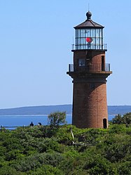
Gay Head Light
| Gay Head Light | ||
|---|---|---|
| Place: | Aquinnah , Massachusetts , United States | |
| Location: | Entrance to Vineyard Sound | |
| Geographical location: | 41 ° 20 '54.4 " N , 70 ° 50' 5.8" W | |
| Fire carrier height : | 51 ft (15.5 m ) | |
| Fire height : | 170 ft (51.8 m ) | |
|
|
||
| Identifier : |
|
|
| Scope knows: | 24 nm (44.4 km ) | |
| Scope red: | 20 nm (37 km ) | |
| Optics: | DCB-224 | |
| Function: | Navigation aid | |
| Construction time: | 1799/1854 | |
| Operating time: | til today | |
The Gay Head Light is a lighthouse near Aquinnah on Martha's Vineyard Island in the state of Massachusetts in the United States . The current structure was commissioned in 1856 and entered the National Register of Historic Places in 1987 as part of the Multiple Property Submission Lighthouses of Massachusetts MPS .
history
On November 18, 1799, the first lighthouse at this location near Aquinnah (until 1997 Gay Head) was put into operation to serve as a navigation aid for ship traffic in Vineyard Sound . There is underwater a natural barrier called Devil's Bridge ( German Devil's Bridge ), which makes the passage tricky. This first tower was octagonal in plan and 47 ft (14.3 m ) high. Right from the start it was very important for the safety of shipping in this area and was therefore one of the first lighthouses to be equipped with a first-order Fresnel lens . The structure was entered on June 15, 1987 with the number 87001464 on the National Register of Historic Places . Due to constant erosion of the coast, the lighthouse was seriously threatened and was moved further inland in spring 2015 as part of an extensive campaign.
architecture
The current structure is designed as a round tower and 51 ft (15.5 m) high. It is made of brick and sandstone .
technology
The lighthouse emits a white or red light beam alternately every 7.3 seconds, which can be seen up to 24 nm (44.4 km ) (white) or 20 nm (37 km ) (red). If the main light malfunctions, the tower emits a white flash of light every 6 seconds ( identifier Fl W 6s). However, the beacon is obscured by the island of Nomans Land in the range of 342 degrees to 359 degrees . Installed through 1952, the Fresnel lens is now on display in the Martha's Vineyard Historical Society Museum in Edgartown .
See also
Web links
Individual evidence
- ↑ a b c Coast Guard Lighthouses. United States Coast Guard , accessed May 15, 2015 .
- ^ National Register Information System . In: National Register of Historic Places . National Park Service . Retrieved March 13, 2009.
- ^ Save the Gay Head Lighthouse Committee: Save the Gay Head Lighthouse. Retrieved May 15, 2015 .
- ↑ Light List Volume I. ( PDF ) Department of Homeland Security , United States Coast Guard , 2015, p. 143 , accessed on May 15, 2015 (English).


