
On the circle
The Rundling is the original village center of the original district of Alt-Radebeul of the Saxon city of Radebeul , today the street Am Kreis . It emerged from a West Slavic round village with originally eight, later twelve farms. The horseshoe-shaped sack village lies as if cut off only above the lower edge to the lake meadows , which are part of an old Elbarm . In the middle of the square, whose road space is formed as a bypass, is located on the Anger surface a raised island of trees with a large specimen tree ( -leaved lime). On this green island there is a memorial stone with a high water mark for the 2002 Elbe flood .

About 200 meters to the west on Serkowitzer Strasse is the Brunnenplatz , where the public village fountain was originally located.
Starting from the Elbfurt near Altserkowitz , the Rennsteig ran in the Middle Ages as a flood-free bypass of the marshy Elbe lowlands along the northern edge of the Seewiesen to the settlement of Alt-Radebeul and from there through the Junge Heide to Klotzsche , from where it is congruent with the Salt Road from the Schenkhübel to Bühlau went.
Development
The small access road to the Rundling itself starts in the north from Serkowitzer Strasse. On the Rundling, the house numbers start on the northeast side with No. 1 and run clockwise to No. 14 on the northwest side of the entrance, which was called Barthstrasse around 1900 . During the GDR era, the entire Alt-Radebeul round was under ensemble protection . The two following the on county property lying still stand today as cultural monuments continue to be listed .

At the circle: access road

At the circle, from the driveway

At the circle, from the Seewiesen exit

At the circle: high water mark under the linden tree


At circle 2
The small, two-story stable house with a gable roof is part of a narrow two-sided courtyard . It is gable constantly facing the street, which is plastered gable roof in a round-arched coupling window. The upper floor on the eaves side shows half-timbering . In the right-hand roof overhang to the courtyard, there is a console dating from 1897 from the renovation of the gable.
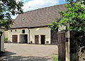
At district 14
The two-storey, plastered residential stable of a stately homestead with ancillary buildings stands with its right eaves side directly on the access road to the Rundling. The building with a gable roof, erected around the middle of the 19th century, has a Kumthalle .
On the left side of the courtyard are two outbuildings, one behind the other. The stable with a vault on four columns was built in 1863 by the master builder Moritz Ziller . In 1895/1896 , the Ziller brothers added a stable with a cap vault to the large barn .
The courtyard entrance, made up of two pillars with a gate, points directly to the Rundling, next to it is a small front garden with a picket fence as an enclosure in front of the stable house .

Residential stable house Am Kreis 2

Homestead Am Kreis 14
Homestead Am Kreis 14, outbuilding

Homestead Am Kreis 14, another outbuilding


Residents
At District 1 or the farm no.16 according to the fire cadastre, the Barth family lived for centuries, making them one of the so-called Twelve Apostles . One of the better-known members of this family was Carl Gottlieb Barth , who, in addition to his function as a farm owner, was also a community chairman, local judge and from 1869 to 1879 a member of the state parliament in the second chamber of the Saxon state parliament .
literature
- Volker Helas (arrangement): City of Radebeul . Ed .: State Office for Monument Preservation Saxony, Large District Town Radebeul (= Monument Topography Federal Republic of Germany . Monuments in Saxony ). SAX-Verlag, Beucha 2007, ISBN 978-3-86729-004-3 .
Web links
- Redevelopment area "center and village center Radebeul-Ost".
- Photo representation of the redevelopment area center and village center Radebeul-Ost.
Individual evidence
- ↑ Newspaper for the redevelopment area "Zentrum und Dorfkern Radebeul-Ost" · No. 4 / May 2007 (PDF; 541 kB)
- ^ Large district town of Radebeul (ed.): Directory of the cultural monuments of the town of Radebeul . Radebeul May 24, 2012, p. 5 f . (Last list of monuments published by the city of Radebeul. The Lower Monument Protection Authority, which has been located in the Meißen district since 2012, has not yet published a list of monuments for Radebeul.).
- ↑ The 12 apostles of Radebeul
Coordinates: 51 ° 5 ′ 48 ″ N , 13 ° 40 ′ 26 ″ E