
Geological Garden Bochum

The Geological Garden in Bochum is located near the street Am Dornbusch in the Altenbochum district . The geological garden was created in 1971.
history
The 2 hectare site was used by the Friederika colliery from 1750 to 1907 . It mined coal and iron ore . From 1925 to 1959 there was a brick factory with a quarry here .
As early as 1962, the site was placed under nature protection, expanded into a geological garden in 1971 and designated as a natural monument ND 1.24 in 1974 .
Evidence of earth development
The outcrop is not as big as that of the Klosterbusch quarry near the Botanical Garden of the Ruhr-Uni Bochum , but it shows a multitude of geological structures from several geological ages , in particular the stratification of sedimentary rocks , thrusts and folds and discordances .
Bochum lies in the transition zone between the layers of chalk in the north and carbon in the south. At this point, the following sections of the earth's history are revealed:
- Carboniferous Period (358–296 million years)
- Cretaceous Period (142–65 million years)
- Quaternary period (1.8 million years - today)
Bochum would have been a seaside resort on the coast of a tropical sea during the Upper Carboniferous period, so ripple marks , reef structures and cliffs are recognizable. The area at the edge of a shallow sea that existed at the time was repeatedly covered by thick layers of dead plant remains, from which coal was formed through the overlaying of younger deposits and subsequent coalification . The originally flat layers would be tilted during the Variscan mountain formation and pushed together in folds.
The coal seams cut in the garden can be assigned to the layer designations that have become established in the mining of the Ruhr area due to their location in the layer composite : in detail, these are the thick bank, thin bank and waterfall seams. These seams enter the daylight here with a northward incidence , they are covered there by glauconitic sandstones from the Upper Cretaceous Period ( Essen green sandstone ).
Various exhibits are on display in the park . Castings, charred trees have been taken by strikes in the coal seams in the region, is here at six strains of scales trees (Lepidodendron) that grew in the Carboniferous period.
Various rocks are exhibited in the northern part of the garden. Next to a chunk of Cretaceous conglomerate , two round, flat disk-shaped concretions about 1 m in diameter can be seen, which were created by the accumulation of dissolved minerals. There are finds from the Cretaceous Period.
The boulders made of gneiss and red granite not far to the west are deep rocks ( plutonites ) that formed under enormous pressure and high temperature at a depth of up to 20 km , which were carried by the ice from Scandinavia to Bochum during the Ice Ages . These stones represent the Quaternary.
Furthermore, some specimens of the ginkgo and the primeval sequoia, which are considered living fossils , were planted in the park .
gallery

An overview of the layout of the Geological Garden in Bochum.
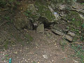
" Old man " view of a collapsed mining tunnel.

“Hard coal forest”, casts of tree trunks found in the hard coal.

Chalk and carbon stratification.

Deposition layers: Top view of a layer, ripple marks can be seen.

Deposits: layers like annual rings on trees.

Angular discordance: on the Carboniferous (320–296 million years ago) lies the layer from the Cretaceous (99–65 million years ago).
Coal seam “waterfall”: A heavily contaminated seam formed in the Upper Carboniferous (320–296 million years ago).

Stratification and fissures , fissures that developed later can be seen in the rock package on the carbon.


literature
- Geological Garden Bochum. (PDF, 2.0 MB) Excursion guide through a natural monument. City of Bochum, Environment Agency, archived from the original on September 29, 2009 .
Individual evidence
- ^ Jill Brehmer: Bochum by the sea . In: WAZ , Bochum local section, February 16, 2008
Web links
- GeoPark Ruhrgebiet: Geological garden.
Coordinates: 51 ° 28 ′ 10 ″ N , 7 ° 14 ′ 2 ″ E