Gerbrandytoren
|
Gerbrandytoren
|
|||||||
|---|---|---|---|---|---|---|---|
| Basic data | |||||||
| Place: | IJsselstein | ||||||
| Province: | Utrecht | ||||||
| Country: | Netherlands | ||||||
| Coordinates: 52 ° 0 '36.2 " N , 5 ° 3' 12.8" E | |||||||
| Use: | Broadcasting station | ||||||
| Accessibility: | Transmission tower not open to the public | ||||||
| Tower data | |||||||
| Building materials : | Concrete , steel , reinforced concrete | ||||||
| Total height : | 372 m | ||||||
| Data on the transmission system | |||||||
| Last modification (antenna) : | August 2, 2007 | ||||||
| Last modification (transmitter) : | August 2007 | ||||||
| Waveband : | FM transmitter | ||||||
| Radio : | VHF broadcasting | ||||||
| Send type: | DVB-T | ||||||
|
|||||||
| Position map | |||||||
|
|
|||||||
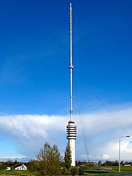
Gerbrandytoren is the tallest building in the Netherlands .
The tower stands between Lopik and IJsselstein (near Utrecht ) and is designed as a hybrid tower : It consists of a 100-meter-high reinforced concrete tower on which a guyed tubular steel mast is placed. It is named after Pieter Sjoerds Gerbrandy , a former prime minister and later Nozema chairman in the 1950s. After construction in 1961, the total height was 382.5 meters; In 1987 it was cut to 375 meters.
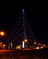
At Christmas time, the gerbrandy tower transformed by the backstays suspended lamps in the highest tree in the world.
On August 2, 2007, when the old television antenna for analogue television was replaced by one for DVB-T, the height was further reduced to 372 meters.
On July 15, 2011, there was a small fire in the tower. As a precaution, the transmission power was reduced and later switched off completely. As a result of these shutdowns, the large cities in the west were no longer supplied with public service programs.
It broadcasts TV and radio programs in the VHF range and is not to be confused with the transmission mast of the medium wave station Lopik .
A few kilometers southwest of the Gerbrandy Tower is a measuring mast of the Dutch weather service.
Programs
| Channel | Frequency (MHz) | ERP (kilowatts) |
|---|---|---|
| SubLime FM | 90.70 | 50 |
| NPO Radio 2 | 92.60 | 72 |
| Radio M | 93.10 | 4th |
| NPO Radio 4 | 94.30 | 50 |
| NPO 3 FM | 96.80 | 72.43 |
| Veronica | 97.80 | 2.1 |
| NPO Radio 1 | 98.90 | 72 |
| BNR | 100.10 | 58 |
| Qmusic | 100.70 | 68 |
| SKYRADIO | 101.50 | 0.066 |
| Radio 538 | 101.90 | 0.2 |
Individual evidence
- ↑ Zendmast crimps negen meter . AD ( online [accessed December 2, 2015]).
- ↑ The television tower in Smilde collapsed. Retrieved July 18, 2011 .
- ↑ fmscan.org: Frequencies. Retrieved December 24, 2019 .


