Germignonville
| Germignonville | ||
|---|---|---|
|
|
||
| local community | Eole-en-Beauce | |
| region | Center-Val de Loire | |
| Department | Eure-et-Loir | |
| Arrondissement | Chartres | |
| Coordinates | 48 ° 12 ′ N , 1 ° 44 ′ E | |
| Post Code | 28140 | |
| Former INSEE code | 28179 | |
| Incorporation | January 1, 2016 | |
| status | Commune déléguée | |
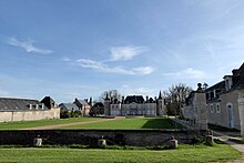
 Saint-Pierre church |
||
Germignonville is a village and a former French community with 223 inhabitants (as of January 1 2017) in the Eure-et-Loir in the region Center-Val de Loire .
With effect from January 1, 2016, the previous municipalities of Baignolet , Viabon , Fains-la-Folie and Germignonville were merged into a Commune nouvelle with the name Eole-en-Beauce and have the status of a Commune déléguée in the new municipality . The administrative seat is in Viabon.
location
Neighboring towns of Germignonville are Viabon in the north-west, Ymonville in the north, Guilleville in the north-east, Allaines-Mervilliers in the east, Tillay-le-Péneux in the south, Loigny-la-Bataille in the south-west and Fontenay-sur-Conie .
Population development
| year | 1962 | 1968 | 1975 | 1982 | 1990 | 1999 | 2008 | 2015 |
|---|---|---|---|---|---|---|---|---|
| Residents | 356 | 292 | 264 | 223 | 199 | 185 | 240 | 218 |
Attractions
- Château de Cambray, Monument historique since 2004
- Saint-Pierre church
Web links
Commons : Germignonville - collection of images, videos and audio files

