
Gerwisch
|
Gerwisch
Unified municipality of Biederitz
|
|
|---|---|
 |
|
| Height : | 45 m above sea level NHN |
| Area : | 7.61 km² |
| Residents : | 2555 (Jan. 1, 2019) |
| Population density : | 336 inhabitants / km² |
| Incorporation : | January 1, 2010 |
| Postal code : | 39175 |
| Area code : | 039292 |
Gerwisch is a district of the unitary community Biederitz in the district of Jerichower Land in Saxony-Anhalt .
geography
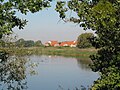
Gerwisch is located on the western edge of the Fläming , four kilometers from the Elbe . The surrounding area is dominated by agriculture with soils of medium quality.
In terms of natural space , the district belongs to the north German lowlands and is divided into two different landscapes. The western parts facing the Elbe belong to the Elbe-Elster lowlands . All other parts, especially all existing parts of the settlement, belong to the Zerbster Land . Both landscapes are open cultivated arable landscapes and the latter also forms the southwestern roof of the Fläming to the Elbe. The entire district is part of the Elbe catchment area.
climate


The annual precipitation is 474 mm extremely low. Lower values are registered at just one percent of the German Weather Service's measuring stations . The driest month is February, with the most rainfall in June.
history
About 150,000 years ago people settled in today's Gerwischer area, which is proven by the Gerwischer hand ax that was found during excavations. Settlement up to the beginning of the Bronze Age could be proven with further excavations . After that, traces of human settlement can only be found again at the beginning of the 1st millennium AD. There is a first written record from the year 992 under the name Grobizi. This contains the Slavic root word "coarse", to be translated as "place at the ditch or grave". The first documentary mention comes from the Magdeburg Archbishop Wichmann from the year 1176, there called Grobiske. The place is listed as Gherwitz or Jerwitz in the so-called “Red Book”, the fiefdom register of the Magdeburg Dompropstei from 1360 to 1370.
The assignment to the Dompropstei lasted until 1810, before this was dissolved together with the entire Magdeburg Cathedral Chapter by the Kingdom of Westphalia . Although its sphere of influence actually ended on the west bank of the Elbe, the ownership of the Dompropstei remained unaffected, ie until it was dissolved, it also exercised land and judicial rule over its East Elbe possessions, including Gerwisch. After the end of Napoleonic rule, Prussia formed the province of Saxony in 1815 and carried out a district reform, with which Gerwisch was incorporated into the Jerichow I district with the district town of Burg.
A great fire destroyed the entire place in 1825. Since the Chaussee Magdeburg - Burg had been built two kilometers further east, Gerwisch was built from scratch there. In 1846 the station was opened on the Magdeburg - Berlin route. This made Gerwisch interesting for the emerging industry at the time, and a sugar factory was established in 1859, a canning factory in 1878 and a gravel works in 1888. However, the sugar factory had to stop production after twenty years, it was demolished and a new housing estate was built on the site northeast of the village. At the beginning of the 20th century, the Prussian army set up a large ammunition depot near Gerwisch, which existed until the end of the First World War . After that, a new settlement was built in its place in the 1920s by the Reichsbahn, while another part was used by a scrap processing plant. After the Second World War , the city of Magdeburg near Gerwisch set up a sewage treatment plant for its wastewater with a pumping station, which was used to sprinkle the surrounding fields.
Even after the end of the GDR, Gerwisch remained an industrial site with a concrete plant, a packaging and recycling company, considering its size. A new housing estate was built west of the railway, so that the number of inhabitants increased considerably.
On October 21, 2006, there was a right-wing extremist attack on a birthday party in Gerwisch, which attracted nationwide attention.
Until December 31, 2009 Gerwisch was an independent municipality. The only incumbent and at the same time last mayor of the Gerwisch municipality was Karla Michalski. On January 1, 2010 Gerwisch was incorporated into the unified community of Biederitz .

Parish and church
Potztrine

Wide path with trees


coat of arms
The coat of arms was approved on December 10, 1993 by the Magdeburg Regional Council.
Blazon : “Quartered; Field 1 and 4: in silver a floating straight-arm red paw cross, field 2 and 3: in blue a swimming silver fish turned to the left. "
In 1825 the community was completely destroyed by a fire disaster. At the place of the old church there is a cross today, which is supposed to remind of these days and the old place. In the same year the place was rebuilt on both sides of the Berliner Chaussee. The fish symbolize the original economic basis of the place.
In 1997 the heraldist Frank Jung was commissioned to redesign the coat of arms.
Buildings
Today's Gerwisch village church was built in 1841 as a replacement for the medieval village church that was destroyed along with the village in the fire of 1825. A classical hall building with a square west tower was erected at a new location .
Transport links
The station Gerwisch is located on the railway line between Berlin and Magdeburg . Gerwisch is located on federal highway 1 halfway between the state capital Magdeburg (12 km away) and the district town of Burg (14 km away) and has a connection to the Magdeburg – Berlin railway line. A junction to the federal motorway 2 is eight kilometers away.
Personalities
Sons and daughters of the place
- Helmut Zimmermann (1924–2013), German city councilor, city history and family researcher and author
Other personalities
- From 1998 to 2005, the former world and European athletics champion Grit Breuer lived in Gerwisch.
Web links
- Gerwisch on gemeinde-biederitz.de
- www.gemeinde-gerwisch.de
Individual evidence
- ↑ Municipality of Biederitz - Ordnungsverwaltung (Ed.): Population figures for the unit municipality of Biederitz - as of 01.01.2019 . 29 January 2019.
- ↑ Map services of the Federal Agency for Nature Conservation ( information )
- ↑ http://www.taz.de/pt/2006/10/26/a0066.1/text
- ↑ StBA: Area changes from January 01 to December 31, 2010
Biederitz | Gerwisch | Gübs | Heyrothsberge | Königsborn | Woltersdorf