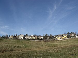
Giuncugnano
| Giuncugnano | |||
|---|---|---|---|

|
|||
| Panorama of Giuncugnano | |||
| Country | Italy | ||
| region | Tuscany | ||
| province | Lucca (LU) | ||
| local community | Sillano Giuncugnano | ||
| Coordinates | 44 ° 13 ' N , 10 ° 15' E | ||
| height | 876 m slm | ||
| Telephone code | 0583 | CAP | 55030 |
Giuncugnano is a district of the municipality of Sillano Giuncugnano in the province of Lucca .
geography
Giuncugnano is at 876 m. The place is in the upper Garfagnana and belongs to the Appennino Tosco-Emiliano National Park . It is connected to Aulla and Castelnuovo di Garfagnana by the state road 45 .
The districts Magliano, Ponteccio, Gragna, Varliano and Capoli also belong to the place.
The neighboring towns are Casola in Lunigiana , Fivizzano , Minucciano , Piazza al Serchio and Sillano .
history
The Magliano and Ponteccio fractions were first mentioned in a document in the 8th century. In the 14th century the place passed from the rule of Lucca into the possession of the Este family , to which it belonged until the unification of Italy . Until December 31, 2014 the place was an independent municipality. Since then, she and Sillano have been part of the new municipality of Sillano Giuncugnano. On December 31, 2013, the community had 481 inhabitants.
In agriculture, cattle and sheep breeding play a particularly important role, there are also businesses in the craft and trade as well as tourism facilities.
literature
- Emanuele Repetti: GIUNCUGNANO di Garfagnana nella Valle del Serchio. In: Dizionario Geografico Fisico Storico della Toscana (1833–1846), online edition of the University of Siena (pdf, Italian)
Web links
Individual evidence
- ↑ Istat ( Istituto Nazionale di Statistica ), accessed on January 7, 2015 (Italian)