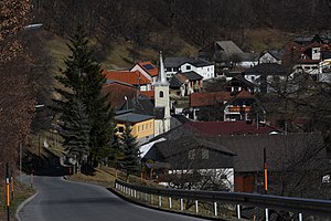
Glassworks near Schlaining
|
Glassworks at Schlaining (location component ) Katastralgemeinde Günseck |
||
|---|---|---|
|
|
||
| Basic data | ||
| Pole. District , state | Oberwart (OW), Burgenland | |
| Judicial district | Oberwart | |
| Pole. local community | Unterkohlstätten | |
| Coordinates (K) | 47 ° 21 '35 " N , 16 ° 19' 47" E | |
| Area d. KG | k. A. Help | |
| Post Code | 7435 | |
| prefix | + 43/03354 | |
| Statistical identification | ||
| Cadastral parish number | 34019 | |
 Glassworks near Schlaining (2017) |
||
| Source: STAT : index of places ; BEV : GEONAM ; GIS-Bgld ;
(K) Coordinate not official
|
||
Glashütten bei Schlaining is a village in Unterkohlstätten in Burgenland .
The place is on the northern slope of the Günser Mountains and is off the road network in a cleared island. The local chapel dates from 1801. The neo-Romanesque church was built in 1816 in honor of Saint Louis of Toulouse .
Glassworks
In 1658 Count Ádám Batthyány built a glassworks here , which is first mentioned as a settlement in 1698. The glassworks became famous because of the sulphurized and therefore yellow shimmering glass work. The enormous amounts of wood needed to make glass were felled in the area.
Mining
In the 19th century, in addition to the gradually declining glass industry, the metal antimony was mined.
Web links
Commons : Glassworks near Schlaining - collection of images, videos and audio files

