Gmina Haczów
| Gmina Haczów | ||
|---|---|---|

|
|
|
| Basic data | ||
| State : | Poland | |
| Voivodeship : | Subcarpathian | |
| Powiat : | Brzozowski | |
| Geographic location : | 49 ° 40 ' N , 21 ° 54' E | |
| Height : | 284 m npm | |
| Residents : | see Gmina | |
| Postal code : | 36-213 | |
| Telephone code : | (+48) 13 | |
| License plate : | RBR | |
| Economy and Transport | ||
| Next international airport : | Rzeszów | |
| Gmina | ||
| Gminatype: | Rural community | |
| Gmina structure: | 7 school offices | |
| Surface: | 90.51 km² | |
| Residents: | 9114 (June 30, 2019) |
|
| Population density : | 101 inhabitants / km² | |
| Community number ( GUS ): | 1802042 | |
| administration | ||
| Wójt : | Stanislaw Jakiel | |
| Address: | Haczów 573 36-213 Haczów |
|
| Website : | haczow.pl | |
The Gmina Haczów is a rural municipality in the powiat Brzozowski of the Subcarpathian Voivodeship in Poland . Their seat is the village of the same name with about 3300 inhabitants.
geography
The municipality is located in the Subcarpathian Mountains , eight kilometers east of Krosno and about twenty kilometers northeast of Sanok . The Wisłok River is one of the waters .
history
In 1772 the places came to the Austrian province of Galicia . Until 1914, the area was part of the Sanok District . With the re-establishment of the Polish state in 1918, the villages came to what was then Powiat Brzozowski of the Lviv Voivodeship in 1920 .
From 1975 to 1998 the municipality belonged to the Krosno Voivodeship .
structure
The following villages with school administration offices belong to the rural municipality of Haczów:
- Buków
- Haczów
- Jabłonica Polska
- Jasionów
- Malinówka
- Trześniów
- Wzdów
Attractions
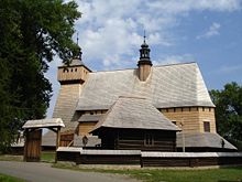
- The late Gothic wooden church (14th century) in Haczów, along with other wooden churches in southern Lesser Poland, has been a UNESCO World Heritage Site since 2003 .
Personalities
- Gustaw Truskolaski (1870-1934), general; born in Jasionów
- Bronisław Prugar-Ketling (1891-1948), general; born in Trześniów
- Marian Konieczny (1930–2017), sculptor; born in Jasionów.
Web links
- Community website (Polish)
Individual evidence
- ↑ population. Size and Structure by Territorial Division. As of June 30, 2019. Główny Urząd Statystyczny (GUS) (PDF files; 0.99 MiB), accessed December 24, 2019 .


