
Godów (Radom)
| Godów | |||
|---|---|---|---|

|
|
||
| Basic data | |||
| State : | Poland | ||
| Voivodeship : | Mazovia | ||
| Powiat : | Radomski | ||
| Gmina : | Radome | ||
| Geographic location : | 51 ° 22 ' N , 21 ° 9' E | ||
| Residents : | |||
| Postal code : | 26-606 | ||
| Telephone code : | (+48) 48 | ||
| License plate : | WR | ||

Godów (formerly Godów Długojowski ) is a district of Radom in the Masovian Voivodeship in Poland , around 4 km south of the city center.
history
The place was mentioned as Godow in 1412 . The possessive name is derived from the personal name God, in the 16th century the name was added with the adjective Dlugoiowski (1569, after the place Długojów).

Politically and administratively the village belonged to the Kingdom of Poland (from 1569 aristocratic republic of Poland-Lithuania ), Sandomir Voivodeship , Radom District. During the Third Partition of Poland in 1795, Godów and Western Galicia were annexed to the Kingdom of Galicia and Lodomeria of the Habsburg Empire . In 1809 it came to the Duchy of Warsaw and in 1815 to the newly formed Russian-dominated Congress Poland . In 1827 there were 9 houses with 94 inhabitants.
In 1859 the village owner Marcin Dunin Sulgostowski sold the arable fields to Polish and German colonists. By 1880 the number of houses rose to 17, the population to 150 and a primary school was opened. The private farms have often been bought back in the meantime, but the Lutherans made up the majority of the residents until the interwar period and Godów was one of the largest parish villages in the Evangelical Augsburg community in Radom.
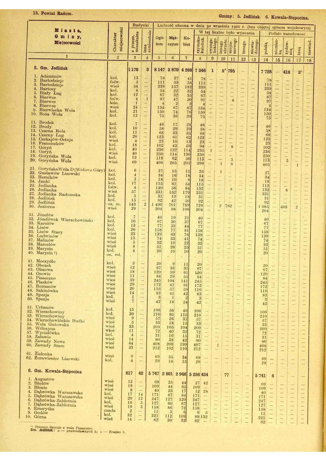
After the end of the First World War , Godów came to Poland. In 1921 the Godów colony in the Kowala-Stępocina parish in the Radomski powiat of the Kielce Voivodeship had 32 houses with 221 inhabitants, all of whom declared themselves Poles, except for 89 Catholics, there were 132 Lutherans (and there were also Polish Protestants living in the parish in Kotarwice - 153, Augustów - 42, Zabierzów - 37, Błonie - 28).
During the Second World War it belonged to the Radom district in the Generalgouvernement .
The district is now built on by single-family houses. From 2009 the former Lutheran cemetery will belong to the parish of Radom again.
literature
- Izabela Bożyk: Osadnictwo niemieckie na terenach wiejskich między Pilicą a Wisłą w latach 1815–1865 . Wydawnictwo MARRON, Kielce – Łódź 2015, ISBN 978-83-64637-80-3 (Polish).
Individual evidence
- ↑ Kazimierz Rymut , Barbara Czopek-Kopciuch: Nazwy miejscowe Polski: historia, pochodzenie, zmiany . 3 (EI). Polska Akademia Nauk . Instytut Języka Polskiego, Kraków 1999, p. 203 (Polish, online ).
- ↑ a b Godów (2) . In: Filip Sulimierski, Władysław Walewski (eds.): Słownik geograficzny Królestwa Polskiego i innych krajów słowiańskich . tape 2 : Derenek – Gżack . Sulimierskiego and Walewskiego, Warsaw 1881, p. 645 (Polish, edu.pl ).
- ↑ I. Bożyk, 2015, p. 89
- ↑ I. Bożyk, 2015, pp. 90, 113, 269
- ↑ Główny Urząd Statystyczny: Skorowidz miejscowości Rzeczypospolitej Polskiej. Tom III. Województwo kieleckie . Warszawa 1925, p. 110 [PDF: 116] (Polish, online [PDF]).
Web links
- Godów (2) . In: Filip Sulimierski, Władysław Walewski (eds.): Słownik geograficzny Królestwa Polskiego i innych krajów słowiańskich . tape 2 : Derenek – Gżack . Sulimierskiego and Walewskiego, Warsaw 1881, p. 645 (Polish, edu.pl ).