
Gulf of Castellammare
| Gulf of Castellammare | ||
|---|---|---|
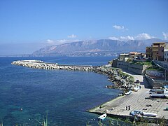
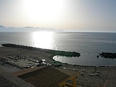
 View of the Gulf of Castellammare
|
||
|
||
| location |
|
|
| Waters | Tyrrhenian Sea | |
| From |
Capo San Vito (TP) 38 ° 11 ′ 0 ″ N , 12 ° 43 ′ 0 ″ E |
|
| To |
Capo Rama (PA) 38 ° 8 ′ 0 ″ N , 13 ° 3 ′ 0 ″ E |
|

Coordinates: 38 ° 10 ' N , 12 ° 55' E
The Gulf of Castellammare ( Italian Golfo di Castellammare ) is a natural bay in the north-west of Sicily . Due to its high coastal mountains, it differs fundamentally from the largely flat coastal regions in the west of the island.
location
The Gulf of Castellammare extends west of Palermo between the capes Capo Rama and Capo San Vito near the municipalities of Terrasini ( Metropolitan City of Palermo ) and San Vito Lo Capo ( Province of Trapani ). The wide bay opens to the Tyrrhenian Sea to the front . The main town and namesake of the bay is the municipality of Castellammare del Golfo (province of Trapani). The highest point of the region is with 1110 m slm of Monte Sparagio at Scopello.
Name story
The origin of the name has not been clearly established. It can be assumed that the bay was initially named after Segesta , which was the most important city on the Gulf for a long time in ancient times. The Latin names Sinus Segestanus and Sinus Aegestanus have been handed down .
Around 300 BC A place called Longuro is mentioned for the first time in the Alexandra of Lycophron . Like the mighty Segesta, it is probably a foundation of the Sikanen and Elymers . Due to its location on Monte Bonifato, which is inaccessible from three sides, Longuro will have survived the Punic Wars well. When the Romans soon chose Sicily as their granary, life there changed. In order to find suitable soil for agriculture, the people had to move into the valley. Longuro on the mountain was abandoned, instead the new place Longarico was built at the foot of the mountain . Findings suggest that Arab settlers later repopulated the area and named their place Alqahm or Alqamah .
The French cartographer Guillaume Delisle documents the settlement on his map of ancient Sicily from 1714 as Locaricum sive Longaricum - and the bay as Sinus Longuri sive Longaricus . In his “new map”, Insulæ et regni Siciliæ novissima tabula , published by Joachim Ottens in Amsterdam around 1717 , the gulf is referred to as Golfo di Castela Mare . Segesta has disappeared and Alcamo has almost exactly taken the place of Longarico .
Economy in the 21st Century
If you look to the right and left at the port of Castellammare del Golfo, there are two completely different landscapes: The eastern side is flat and lined with a strip of sand. In the west, on the other hand, towering up coastal mountains that often reach the sea. The economy flourishes at the apex of the Gulf of Castellammare . It is not quite as rosy in the hinterland and at the eastern tip. These regions have been supported by subsidies since 2001.
Business promotion
The company Sviluppo del Golfo , founded on March 2, 2001, will expire on December 31, 2020. Until then, their area agreement Patto Territoriale Golfo di Castellammare , an agreement between various local authorities and representatives of the social and economic partners, promotes the local development of the Gulf of Castellammare. The partners are the municipalities of the Gulf and the surrounding area, various consortia , the Banca Don Rizzo and the Trapani Province Industrial Association. The main shareholder is the municipality of Alcamo.
In 2010, the local action group GAL Golfo di Castellammare was launched. Various municipalities, businesses, associations and professional associations were involved in implementing a local development plan for the Gulf of Castellammare area. This originally included the systematization and promotion of rural tourism, the participation of the entire area in the tourism industry and the support of agricultural businesses.
GAL communities
The area of the Gruppo di Azione Golfo di Castellammare has an area of 335.75 km² and a population of 119,263 inhabitants (as of December 31, 2011). The main tasks of GAL have changed over the past ten years. Today they lie in promoting sustainable tourism, the development and innovation of local production systems (food, forestry, handicrafts, manufacturing) and the social inclusion of disadvantaged population groups. The following 8 municipalities belong to the territory of the GAL:
Alcamo : The municipality of Alcamo is located on the slopes of Monte Bonifato at 258 m above sea level. With the seaside resort of Alcamo Marina , it extends to the coast of the Gulf of Castellammare. Alcamo is known as the “city of wine and art”. She proudly looks out over the surrounding vineyards, her castle and numerous palaces and churches.
Balestrate : Located in the center of the Gulf of Castellammare, the municipality of Balestrate scores above all with its beach. In addition to summer tourism, wine is a source of income for the residents. The place lies in the valley of the Cataldo river, behind it the Monte Ferricini rises .
Borgetto : The town of Borgetto is located on the slope of a hill at 290 m above sea level opposite the Conca d'Oro . From here you can enjoy a wide view over the Gulf of Castellammare. The municipality's coat of arms shows a tower, an indication of the origin of the place name from the Greek "burgos" (castle).
Cinisi : The place Cinisi is located at the foot of the Pizzo Corvo . Lemons and oranges, olives and the fruits of the carob tree grow in the hilly area. The municipality of Cinisi also includes the Palermo airport on the Punta Raisi headland .
Partinico : Partinico is the second largest municipality in the GAL after Alcamo. The place lies in the plain on the slopes of Monte Gradara in the valley of the river Nocella and is an important agricultural center. In the municipal museum ( Museo Civico ) numerous stone tools from prehistoric times are exhibited.
Terrasini : Terrasini reaches as far as the coast of the Gulf of Castellammare. The name is probably derived from Terra Sinus, land on the Gulf. The inhabitants work mainly in agriculture, fishing and tourism. A special highlight is the varied museum landscape.
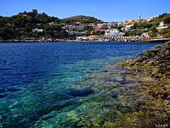
Trappeto : Like Terrasini and Balestrate, Trappeto is a coastal town in the east of the Gulf of Castellammare. Its beaches attract numerous tourists in summer. In addition to beach tourism, fishing is an important source of income, and the local fish market is still well stocked. Colorful coral reefs lie off the coast.
Ustica : The only island in the association of the Local Action Group is far outside the Gulf of Castellammare, but is well connected from Palermo. Ustica's location speaks for rich fishing grounds, the fertile soil for productive agriculture. Visitors come mainly for the species-rich underwater world, the brightly painted houses, the Bronze Age village I Faraglioni and the Grotta Azzurra and Grotta delle Barche sea caves .
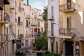
Alcamo: old town

Balestrate: parish church
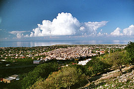
Cinisi: View of the plain
Trappeto: fishing port
Ustica: the place on the island of the same name


Hot spots
Especially in the apex of the gulf, the communities are not dependent on funding from the local action group. Fishing , the handling of goods and especially tourism ensure that the population has a sufficient income.
places
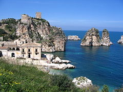
Castellammare del Golfo : The name giver of the Gulf of Castellammare is both geographical and economic center of the region. Thanks to the favorable location and the same transport connections, the products of the region are handled here. The small town is by no means dependent on tourism, instead it is largely determined by the everyday life of fishermen and traders. The landmark Castellammares is a castle that was still washed by the sea as Castello a mare until the 1980s.
Scopello : In summer, the tranquil part of the city of Castellammare del Golfo is unrecognizable - when hordes of tourists flock through the streets. Scopello also has a lot to offer: spectacular cliffs ( faraglioni ), one of the oldest tuna factories in Sicily ( tonnara ) and an entrance to the Zingaro Nature Park.
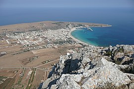
San Vito Lo Capo : Surrounded by the seemingly endless beaches of the Gulf in the north, the Monte Monaco mountain range in the east, the steep rocky cliffs of Scogliera di Salinella in the west and the Riserva Naturale dello Zingaro in the south, the seaside resort of San Vito Lo Capo is popular with nature lovers , Climbers and sun-seekers alike. Outside the village there is agriculture and fishing, and marble is also mined on Monte Sparagio .

Castellammare del Golfo
Scopello: Faraglioni and tonnara
San Vito Lo Capo - view from Monte Monaco


Nature reserves
Zingaro Nature Reserve (Italian: Riserva Naturale orientata dello Zingaro ): Only a few species of mammals live in the oldest nature reserve in Sicily, including porcupines , foxes and bats. However, birds, including some rare species of birds of prey, are numerous. The flora knows dwarf palms , orchids and about 700 other species. You have to allow around 5 hours for the circular route.
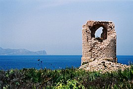
Capo Rama nature reserve (Italian: Riserva Naturale orientata Capo Rama ): The nature reserve established in 2000 on the opposite side of the bay is much less well known. It is much smaller, but in addition to the fauna and flora, it offers many fossils and caves. The ruins of the coastal tower Torre di Capo Rama watch over everything .

On the way through the Zingaro nature reserve
Coastal tower at Capo Rama

Hera Temple in Segesta


,_Calatafimi-Segesta.JPG)
Segesta ancient city
Segesta is in the area of the municipality of Calatafimi : some preserved foundation walls give an idea of how big the Elymer city must have been. Two very remarkable buildings attract many thousands of visitors every year: the Greek theater and the never finished Ionic temple of Hera .
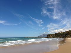
beaches
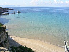
The beaches on the Gulf of Castellammare are characterized by golden and white sand. Between Capo Rama and Capo San Vito there is a total of approx. 360 km 2 of beach.
Terrasini Beach
Trappeto Beach
Balestrate Beach
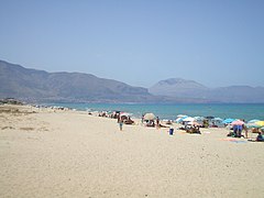
Alcamo Marina Beach

San Vito lo Capo beach


.JPG)


Web links
Individual evidence
- ↑ GAL Golfo di Castellammare - comune Terrasini , galgolfodicastellammare.eu (accessed March 10, 2020)
- ↑ Alcamo e le origini da Longuro, Longarico , eventitrapani.it (archived January 4, 2015)
- ↑ Siciliæ antiquæ and Insulæ et regni Siciliæ novissima tabula , Gallica of the BnF; Insulæ et regni Siciliæ novissima tabula , University and State Library Düsseldorf
- ^ Società Sviluppo del Golfo , sviluppodelgolfo.it (archived March 4, 2015)
- ↑ GAL Golfo di Castellammare - chi siamo , galgolfodicastellammare.eu (archived July 5, 2015)
- ↑ GAL Golfo di Castellammare - GAL , galgolfodicastellammare.eu (accessed March 10, 2020)
- ↑ GAL Golfo di Castellammare - comuni , galgolfodicastellammare.eu (accessed March 10, 2020)
- ↑ I comuni del Golfo di Castellamare , golfodicastellammare.net (archived February 16, 2015)