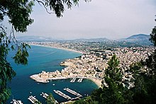
Castellammare del Golfo
| Castellammare del Golfo | ||
|---|---|---|

|
|
|
| Country | Italy | |
| region | Sicily | |
| Free community consortium | Trapani (TP) | |
| Local name | Casteddammari | |
| Coordinates | 38 ° 2 ' N , 12 ° 53' E | |
| height | 26 m slm | |
| surface | 127 km² | |
| Residents | 15,072 (Dec. 31, 2019) | |
| Population density | 119 inhabitants / km² | |
| Factions | Balata di Baida , Scopello , Guida Loca , Fraginesi , Lu Baruni | |
| Post Code | 91014 Capoluogo e Scopello, 91010 Balata di Baida | |
| prefix | 0924 | |
| ISTAT number | 081005 | |
| Popular name | Castellammaresi | |
| Patron saint | Maria Santissima del Soccorso | |
| Website | Castellammare del Golfo | |
Castellammare del Golfo is an Italian municipality in the Free Community Consortium Trapani in the autonomous region of Sicily with 15,072 inhabitants (as of December 31, 2019).
Location and dates
The municipality is 40 km east of Trapani and 67 km west of Palermo , at the apex of the Gulf of Castellammare , which opens to the Tyrrhenian Sea . The place covers an area of 127 km². The inhabitants live from agriculture, the furniture industry, marble processing and tourism. The municipality is a member of the Regione Agraria n. 2 - Colline litorale di Erice and the Patto Territoriale Golfo di Castellammare ; because of the Terme Segestane it is also considered a thermal resort.
The districts are Balata di Baida, Castello Inici, Dagala Secca, Fraginesi and Scopello .
The neighboring municipalities are Alcamo , Buseto Palizzolo , Calatafimi Segesta , Custonaci and San Vito Lo Capo .
Castellammare del Golfo is on the SS 187 and on the Palermo – Trapani railway line . The travel time to Trapani is around 1 hour and to Palermo around 1.5 hours. The nearby A29 can be reached via its own access road to the Castellammare del Golfo junction .
history
In ancient times the place was a port for Erice and for Segesta , one of the most important cities of the Elymians . The Arabs further developed the city and built a castle with a trapezoidal floor plan that could only be reached via a removable wooden bridge. Al-Idrisi , the geographer Rogers II, describes Al Madarig so precisely that it can be identified with the current system, although no recognizable components can be traced back to the Arab or Norman times. It was first destroyed by Frederick II of Sicily at the beginning of the 14th century and then rebuilt. Further changes took place in the 16th century.
The tuna fishing brought an economic boom. In the Scopello district there is still a tonnara, a former tuna fishing station.
The Castellammare War , a bloody power struggle within the Mafia in New York City around 1930, takes its name from the place, as some of the adversaries came from Castellammare del Golfo and the surrounding area.
Buildings and cityscape
- Parish church of Maria Santissima del Soccorso from the 17th and 18th centuries
- Castle from the 14th century, today the seat of the Polo Museum “La Memoria del Mediterraneo” with the departments Museo dell'Acqua e dei Mulini (Museum of Water and Mills), Museo delle Attività Produttive (Fondazione “Annalisa Buccellato”) (Commercial Museum) , Museo Archeologico and Museo delle Attività Marinare (mainly dedicated to tuna fishing)
- Scopello, the tourist center of Castellammare del Golfo
Surroundings
- Terme Segestane, warm sulphurous springs 7 km south of the city, località Ponte Bagni
- Riserva naturale dello Zingaro , a nature reserve
- Monte Inici
sons and daughters of the town
- Antonio Veneziano (1543–1593), Italian poet
- Salvatore Maranzano (1886–1931), boss of the Bonanno family
- Giuseppe Aiello (1890–1930), mafioso in Chicago , president of the Unione Siciliana , opponent of Al Capone
- Stefano Magaddino (1891–1974), Buffalo Mafia boss
- Joseph Magliocco (1898–1963), Mafioso
- Joseph Bonanno (1905–2002), boss of the American Mafia clan in New York City, later classified as the Bonanno family
- Carmine Galante (1910-1979), Mafioso
- Piersanti Mattarella (1935–1980), President of the Sicily Region
Films shot in Castellammare del Golfo
- Ocean's 12th
- Avenging Angelo
- My name is Tanino
- Cefalonia, TV series
- Commissario Montalbano , Il senso del tatto
Individual evidence
- ↑ Statistiche demografiche ISTAT. Monthly population statistics of the Istituto Nazionale di Statistica , as of December 31 of 2019.
- ^ Ferdinando Maurici: Castelli medievali in Sicilia. Dai bizantini ai normanni (= La Pietra vissuta. Vol. 5). Sellerio, Palermo 1992, p. 278. The interpretation of the Arabic name is disputed


