
Castelvetrano
| Castelvetrano | ||
|---|---|---|

|
|
|
| Country | Italy | |
| region | Sicily | |
| Free community consortium | Trapani (TP) | |
| Local name | Castedduvitranu | |
| Coordinates | 37 ° 40 ′ N , 12 ° 48 ′ E | |
| height | 187 m slm | |
| surface | 206 km² | |
| Residents | 30,783 (Dec 31, 2019) | |
| Population density | 149 inhabitants / km² | |
| Factions | Triscina di Selinunte , Marinella di Selinunte | |
| Post Code | 91022 | |
| prefix | 0924 | |
| ISTAT number | 081006 | |
| Popular name | Castelvetranesi (outdated: Selinuntini) | |
| Patron saint | San Giovanni Battista | |
| Website | Castelvetrano | |

Castelvetrano is a municipality in Trapani consortium of municipalities outside the region Sicily in Italy with 30,783 inhabitants (December 31, 2019).
Location and dates
Castelvetrano is 70 kilometers south of Trapani at an altitude of 187 m. The municipality covers an area of 206 km². The population lives mainly from agriculture (olives and wine), the food industry and tourism.
Castelvetrano is on the Palermo – Trapani railway line and has a train station close to the center . The driving time to Palermo is one hour.
The A29 / E90 motorway passes Castelvetrano.
The settlements Triscina di Selinunte and Marinella di Selinunte are frazioni (= districts) of Castelvetrano.
Neighboring communities are Campobello di Mazara , Mazara del Vallo , Menfi ( AG ), Montevago ( AG ), Partanna , Salemi and Santa Ninfa .
history
Ancient necropolises show that the area was inhabited long ago. The ancient Greek Selinous was in what is now the city. The Romans and Arabs also ruled here. From 1299 the community became a fiefdom and developed into a city.
During the Second World War there was a military airfield near Castelvetrano .
Cityscape and buildings
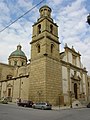
- Piazza Garibaldi, the center of the city with the town hall, the Chiesa Madre church from the 16th century and the Fontana della Ninfa (Fountain of the Nymphs)
- City center with strongly Arabic architecture
- Villa Garibaldi, a public park with views of the city and the surrounding area
- Church of San Domenico from 1470, inside you can see stucco and frescoes from 1577, the church was damaged in the 1968 earthquake
- Church of San Giovanni from the 16th century, rebuilt on the ruins at the end of the 18th century
- City museum with finds from Selinunte

Chiesa Madre

Chiesa Madre with the Torre Campanaria
Chiesa di San Giovanni


Surroundings
- Selinunte , an ancient Greek place near the hamlet of Marinella di Selinunte on the coast with eight Greek temples, which are among the most important sights in Sicily
- Santissima Trinità di Delia , a church 4 kilometers west of Castelvetrano, built between 1140 and 1160 in the Arab-Norman style
- Rocche di Cusa, ancient quarries 11 kilometers southwest of Castelvetrano in the area of the municipality of Campobello di Mazara , here the columns for the temple G in Selinunte were broken
- Grandi Cave, an ancient quarry
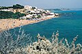
Marinella di Selinunte district
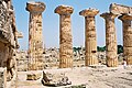
Temple E in Selinunte

Rocche di Cusa

Church of Santissima Trinità di Delia


Web links
- Official site of Castelvetrano (Italian)
Individual evidence
- ↑ Statistiche demografiche ISTAT. Monthly population statistics of the Istituto Nazionale di Statistica , as of December 31 of 2019.
- ↑ Location: ⊙ . Used today by microlight aircraft. Details on ulm.it and on forgottenairfields.com

Alcamo | Buseto Palizzolo | Calatafimi Segesta | Campobello di Mazara | Castellammare del Golfo | Castelvetrano | Custonaci | Erice | Favignana | Gibellina | Marsala | Mazara del Vallo | Paceco | Pantelleria | Partanna | Petrosino | Poggioreale | Salaparuta | Salemi | San Vito Lo Capo | Santa Ninfa | Trapani | Valderice | Vita