
Salemi
| Salemi | ||
|---|---|---|

|
|
|
| Country | Italy | |
| region | Sicily | |
| Free community consortium | Trapani (TP) | |
| Local name | Salemi | |
| Coordinates | 37 ° 49 ′ N , 12 ° 48 ′ E | |
| height | 446 m slm | |
| surface | 181 km² | |
| Residents | 10,378 (Dec. 31, 2019) | |
| Population density | 57 inhabitants / km² | |
| Post Code | 91018 | |
| prefix | 0924 | |
| ISTAT number | 081018 | |
| Popular name | Salemitani | |
| Patron saint | San Nicola | |
| Website | Salemi | |

|
||

Salemi is an Italian municipality in the free municipal consortium of Trapani in the autonomous region of Sicily with 10,378 inhabitants (as of December 31, 2019) and is a member of the association I borghi più belli d'Italia (The most beautiful places in Italy)
Location and dates
Salemi is located at an altitude of 446 m, 37 km southeast of Trapani . The inhabitants, who live in an area of 181 km², work mainly in agriculture and wood processing. Top craftsmanship has a long tradition.
Salemi has a connection to the Palermo – Trapani railway with the Salemi-Gibellina station . The A29 / E90 motorway is around 4 km from the Salemi.
The neighboring municipalities are Calatafimi Segesta , Castelvetrano , Marsala , Mazara del Vallo , Santa Ninfa , Trapani and Vita .
history
Salemi is of Sican or Elymic origin. The ancient name was Halicyae. In Roman times the city was one of the free cities in Sicily. In the Middle Ages the Arabs ruled. During their time they expanded the city and fortifications. The name of the city comes from this time: the Arabic word salam means health, peace and is also used as a name. Giuseppe Garibaldi declared himself to be the “dictator of Sicily” in a proclamation read on May 14, 1860 from the balcony of Salemi Castle.
The city suffered severe damage in the 1968 earthquake. Only part of the old city was restored, part of the population moved into new buildings towards the valley.
Attractions
- The castle built in the 13th century by Friedrich II
- Parish church, only the choir is left here
- Jesuit college, built in the 17th century, is now the parish museum
- Church of Sant'Agostino near the town hall
- Basilica of San Miceli from Byzantine times
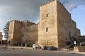
Castello di Salemi

Chiesa Madre, 2015

Church choir

Former Jesuit college

Sant'Agostino

Alley in Salemi


.jpg)

Web links
- Website of the municipality of Salemi (Italian)
Individual evidence
- ↑ Statistiche demografiche ISTAT. Monthly population statistics of the Istituto Nazionale di Statistica , as of December 31 of 2019.
- ^ I borghi più belli d'Italia. Borghipiubelliditalia.it, accessed June 19, 2017 (Italian).
- ↑ Museo Centrale del Risorgimento (ed.): Guida storico-artistica . Gangemi, Rome 2012, ISBN 978-88-492-2387-3 , p. 68 (catalog for the permanent exhibition).

Alcamo | Buseto Palizzolo | Calatafimi Segesta | Campobello di Mazara | Castellammare del Golfo | Castelvetrano | Custonaci | Erice | Favignana | Gibellina | Marsala | Mazara del Vallo | Paceco | Pantelleria | Partanna | Petrosino | Poggioreale | Salaparuta | Salemi | San Vito Lo Capo | Santa Ninfa | Trapani | Valderice | Vita