
Hama Governorate
| Ḥamāh / حماة Hama
|
|
|---|---|
  |
|
| Basic data | |
| Country | Syria |
| Capital | Hama |
| surface | 8844 km² |
| Residents | 1,416,000 (2005) |
| density | 160 inhabitants per km² |
| ISO 3166-2 | SY-HM |
Coordinates: 35 ° 14 ' N , 37 ° 10' E
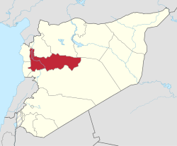
The Hama Governorate ( Arabic محافظة حماة, DMG Muḥāfaẓat Ḥamāh ) is one of the 14 Syrian governorates and is located in the west-central part of the country. Depending on the source, the area is between 8,844 km² and 8,883 km². The population is 1,416,000 people (as of 2005). The administrative center is Hama , another important city in this governorate is Kafr Buhum .
Districts
The governorate is divided into five districts (Mintaqa):
| District | Places (main place in bold) |
|---|---|
| Hama District | Abu Ajwa, Hama , al-Hamra ', Hirbnafsah, Suran |
| Masyaf district | Ain Halaqim, Awj, Jubb Ramla, al-Hurayf, Masyaf , Wadi al-Uyun |
| Maharda district | Kafr Zita, Karnaz, Maharda |
| Salamiyya district | Barri Sharqi, as-Saʿn, Sabbura, Salamiyya , Uqayribat |
| District as-Suqailabiyya | Qal'at al-Mudiq, Tell Salhab, Shatha, as-Suqailabiyya , az-Ziyara |
Web links
Commons : Hama Governorate - Collection of images, videos and audio files
Aleppo | Damascus | Darʿā | Deir ez-Zor | Hama | al-Hasakah | Homs | Idlib | Latakia | al-Quneitra | ar-Raqqa | Rif Dimashq | as-Suwaida | Tartus