
Ar-Raqqa Governorate
| ar-Raqqa / الرقة ar-Raqqa
|
|
|---|---|
  |
|
| Basic data | |
| Country | Syria |
| Capital | ar-Raqqa |
| surface | 19,616 km² |
| Residents | 760,000 (2006) |
| density | 39 inhabitants per km² |
| ISO 3166-2 | SY-RA |
 |
|
Coordinates: 36 ° 1 ' N , 38 ° 54' E
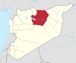
ar-Raqqa ( Arabic الرقة) is a governorate in northern Syria with an area of 19,616 km² and around 760,000 inhabitants (as of 2006).
geography
ar-Raqqa borders on Turkey to the north, the Aleppo governorate to the west, the al-Hasakah governorate to the east and the Deir ez-Zor governorate to the south . The capital and largest city at the same time is the city of the same name ar-Raqqa . Other cities are ath-Thaura and Tall Abyad .
population
The population is mainly composed of Arabs , a large part of which are Bedouins . In the north of the province along the Turkish border, Kurds also live in their villages.
economy
Agriculture consists mainly of cotton growing along the Euphrates .
Districts
The governorate is divided into three districts (Mintaqah):
| District | Places (main place in bold) |
|---|---|
| Tall Abyad District | Ain Issa , Suluk , Tall Abyad |
| Ath-Thaura district | al-Jarniyya, al-Mansura , ath-Thaura |
| Ar-Raqqa district | al-Karama, Maʿdan, al-Qahtaniyah, ar-Raqqa , as-Sabcha |
Web links
Aleppo | Damascus | Darʿā | Deir ez-Zor | Hama | al-Hasakah | Homs | Idlib | Latakia | al-Quneitra | ar-Raqqa | Rif Dimashq | as-Suwaida | Tartus