
Deir ez-Zor governorate
|
دير الزور Dair az-Zaur Deir ez-Zor
|
|
|---|---|
  |
|
| Basic data | |
| Country | Syria |
| Capital | Deir ez-Zor |
| surface | 33,060 km² |
| Residents | 1,500,000 |
| density | 45 inhabitants per km² |
| ISO 3166-2 | SY-DY |
 |
|
Coordinates: 35 ° 9 ′ N , 40 ° 16 ′ E
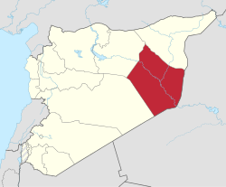
Deir ez-Zor ( Arabic دير الزور, DMG Dair az-Zaur ) is a governorate in eastern Syria with an area of 33,060 km² and an estimated 1.5 million inhabitants.
Location and population
Deir ez-Zor Governorate is located in the Syrian desert and borders Iraq to the east . The capital and largest city is Deir ez-Zor . Other places are al-Bukamal , al-Mayadin and Hajjin . The province is traversed by the Euphrates , into which the largest Syrian tributary Chabur flows from the north near the city of al-Buseira .
The population is largely composed of Arabs , a certain part of whom are Bedouins .
Districts
The governorate is divided into three districts (Mintaqa):
| District | Places (main place in bold) |
|---|---|
| Al-Bukamal district | al-Bukamal , al-Jala ', Hajin |
| Deir ez-Zor district | al-Busaira, Deir ez-Zor , al-Muhasan, Sur, at-Tibnī |
| Al-Mayadin district | al-Ashara, Diban, al-Mayadin |
economy
There are various oil production areas, some with initial refining on site. In addition, along the Euphrates and Chabur rivers, cattle breeding and agriculture with irrigation are practiced.
Political situation
The province is repeatedly contested in the Syrian civil war . In February 2018, forces from the Islamic State (Organization) , the “Syrian Arab Republic” and the Kurds were in the region. The Euphrates formed an approximate demarcation line between the Assad-loyal forces and the Kurdish forces, while the IS controls the Euphrates in the border area with Iraq in the south of the province.
In September 2017, the SDF (Kurdish Forces, supported by the USA) reported the capture of important gas and oil fields in the region around Deir ez-Zor.
In February 2018, various media reported that the head of Islamic State, Abu Bakr al-Baghdadi , is said to be in the region. He is wounded and has diabetes . He can no longer walk without support.
Web links
Individual evidence
Aleppo | Damascus | Darʿā | Deir ez-Zor | Hama | al-Hasakah | Homs | Idlib | Latakia | al-Quneitra | ar-Raqqa | Rif Dimashq | as-Suwaida | Tartus