Grafendorf (Kirchbach municipality)
|
Grafendorf ( village ) locality cadastral community Grafendorf |
||
|---|---|---|
|
|
||
| Basic data | ||
| Pole. District , state | Hermagor (HE), Carinthia | |
| Judicial district | Hermagor | |
| Pole. local community | Kirchbach | |
| Coordinates | 46 ° 39 '20 " N , 13 ° 6' 34" E | |
| height | 655 m above sea level A. | |
| Residents of the village | 520 (January 1, 2020) | |
| Building status | 144 (2001) | |
| Area d. KG | 22.18 km² | |
| Statistical identification | ||
| Locality code | 00466 | |
| Cadastral parish number | 75102 | |
| Counting district / district | Reisach (20306 001) | |
| Source: STAT : index of places ; BEV : GEONAM ; KAGIS | ||
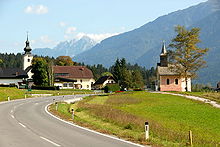
Grafendorf is the largest town in the market town of Kirchbach in the Carnic region of Austria, is located in the Upper Gail Valley at an altitude of 660 m and has around 570 inhabitants.
In 1206 the place was first mentioned as Grauendorf , later as Grevendorf .
Grafendorf is a little off the Gailtalbundesstraße and therefore has a great quality of living and relaxation. The mountain farms Schmalzgrube, Welzberg, Katlingberg and Lenzhof, which form their own localities, are located above Grafendorf on sloping terraces on the sunny side. The Reisskofelbad health resort is located at the foot of the Reisskofel.
Attractions
- Parish church of St. Michael , Romanesque-Gothic, with baroque additions
- Chapel To the Suffering Redeemer
- Church of St. Helena am Wieserberg , Romanesque building
literature
- Thomas Steppan: Sankt Helena am Wieserberg . The late Romanesque wall paintings. In: Great Art Guides / Churches and Monasteries . tape 243 . Schnell and Steiner, Regensburg 2009, ISBN 978-3-7954-2215-8 .

