Kirchbach (Carinthia)
|
market community Kirchbach
|
||
|---|---|---|
| coat of arms | Austria map | |
|
|
||
| Basic data | ||
| Country: | Austria | |
| State : | Carinthia | |
| Political District : | Hermagor | |
| License plate : | HE | |
| Surface: | 99.07 km² | |
| Coordinates : | 46 ° 38 ' N , 13 ° 11' E | |
| Height : | 640 m above sea level A. | |
| Residents : | 2,502 (January 1, 2020) | |
| Population density : | 25 inhabitants per km² | |
| Postal code : | 9632 | |
| Area code : | 04284 | |
| Community code : | 2 03 06 | |
| NUTS region | AT212 | |
| Address of the municipal administration: |
No. 155, 9632 Kirchbach | |
| Website: | ||
| politics | ||
| Mayor : | Hermann Jantschgi ( FPÖ ) | |
|
Municipal Council : ( 2015 ) (19 members) |
||
| Location of Kirchbach in the Hermagor district | ||
| Source: Municipal data from Statistics Austria | ||
Kirchbach ( Cirkno ) is a market town with 2502 inhabitants (as of January 1, 2020) in the Hermagor ( Šmohor ) district in Carinthia ( Koroška ).
geography
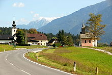
The municipality is located in the Upper Gailtal ( Ziljska dolina ) between the Gailtal Alps in the north and the Carnic Alps in the south, which also form the national border with Italy.
Community structure
The community is divided into the four cadastral communities Grafendorf, Reisach, Kirchbach and Waidegg . The municipal area includes the following 31 localities (population in brackets as of January 1, 2020):
- Brown (1)
- Bodenmuehl (6)
- Forest (31)
- Goderschess (57)
- Grafendorf ( Kneža ) (520)
- Grimitz ( Grm (ov) nica ) (43)
- Gundersheim (285)
- Hochwart (18)
- Katlingberg (3)
- Kirchbach ( Cirkno ) (472)
- Rubbed (2)
- Lenzhof (9)
- Oberbuchach (21)
- Oberdöbernitzen ( Debrevnica ) (46)
- Rauth ( Rut (e) ) (5)
- Reisach ( Riže ) (359)
- Reisskofelbad (10)
- Rinsenegg (1)
- Schimanberg (28)
- Lard Pit (11)
- Schönboden (4)
- Staudachberg (4)
- Stöfflerberg (17)
- Stranig ( Stranik ) (91)
- Tramun (5)
- Treßdorf (188)
- Unterbuchach (6)
- Unterdöbernitzen (21)
- Waidegg ( Baidek ) (227)
- Wassertheurerberg (4)
- Welzberg (7)
Neighboring communities
| mountain | Greifenburg | Gitschtal |
| Dellach |

|
Hermagor-Pressegger See |
| Paularo |
climate
|
Average monthly temperatures and precipitation for Reisach
|
|||||||||||||||||||||||||||||||||||||||||||||||||||||||||||||||||||||||||||||||||||||||||||||||||||||||||||||||||||||||||||||||||||||||||||||||||||||||||||||||||||||||||
history
In the Gailtal was already since the 4th century BC. Mining operated. Around 15 BC The Romans occupied the area and the town of Troi Risa, located between the present-day towns of Reisach and Gundersheim, was an important trading center for the metal trade; the city was allegedly buried around the year 470 by a landslide from the Reisskofel.
The main town of Kirchbach, which gives the municipality its name, developed around the church of St. Martin , which was probably built from the parish of the mother parish of St. Daniel as early as 1070/1140 by the Patriarch of Aquileja , who exercised ordinary rights here until the 18th century has been outsourced and made independent. The small, now largely destroyed Castle Waidegg above the village of the same name was in fiefdom from 1288 for the first time mentioned ministries of the Counts of Görz-Tirol . Further noble residences in today's municipality were the Fronthurm in Reisach and the Thurnhof in Kirchbach.
In 1525 Upper Carinthia belonged to the County of Ortenburg and was administered by the Princes of Porcia until 1848 .
From 1850 the local parishes were formed in Carinthia. In today's municipality, Kirchbach, Reisach (Reisach and Grafendorf) and Weidegg (renamed Waidegg in 1957) were three independent local churches. In 1964 Waidegg was attached to the municipality of Rattendorf , before the current large municipality of Kirchbach was created in the course of the municipal structural reform in 1973 through the amalgamation of Kirchbach, Reisach and the cadastral municipality of Waidegg. This was granted 1997 the right to use the designation market municipality .
During the First World War, the Gailtal was part of the front between Austria and Italy , which can still be seen today as trenches, as well as heroes' cemeteries and war memorials. The Gailtalbahn was also extended during the war to carry cannons through the municipality.
Culture and sights
population
At the time of the 2001 census, Kirchbach had 2,881 inhabitants, 97.2% of whom were Austrian and 1.2% German . 70.6% of the population professed the Roman Catholic Church , 27.7% the Protestant Church and 0.7% are of the Islamic faith. 0.7% gave no religious belief.
politics
Municipal council
The Kirchbach municipal council has 19 members and has been composed as follows since the 2015 municipal council election :
The directly elected mayor has been Hermann Jantschgi (FPÖ) since 2009.
coat of arms
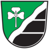
In the coat of arms of Kirchbach, which was awarded to the municipality on April 22, 1987, the corrugated bar symbolizes the Gail , the three-leaf clover was taken from the coat of arms of Kirchbach Castle and also reminds of the three predecessor communities that were united in 1973, and the rear half of the shield with the two horizontal ones Threads is an allusion to the traditional local rural construction, in which the joints of the often dark stained log houses were coated with lime mortar. The colors black and silver are reminiscent of the coat of arms of the Lords of Waidegg, which was taken over in 1960 by the then still independent municipality of Waidegg.
The blazon of the coat of arms reads: “In the shield on the left, which is divided by a silver wavy bar, a silver clover leaf above in green, below black divided twice by silver threads.” The flag is green and black with an incorporated coat of arms.
Personalities
- Karl Engel (1889–1985), artist
- Georg Essl I (1861–1940), businessman and entrepreneur born in Reisach
- Hermann Jantschgi (* 1964), mayor
- Franz Unterberger (1870–1954), Mayor of Feldkirch (Vorarlberg), Vorarlberg Regional Councilor, Member of Parliament and National Councilor
Web links
- Market town of Kirchbach
- 20306 - Kirchbach (Carinthia). Community data, Statistics Austria .
Individual evidence
- ↑ Statistics Austria: Population on January 1st, 2020 by locality (area status on January 1st, 2020) , ( CSV )
- ^ Statistics Austria, population census, demographic data. May 15, 2001, accessed March 3, 2019 .
- ^ Quoted from Wilhelm Deuer: The Carinthian municipal coat of arms . Verlag des Kärntner Landesarchiv, Klagenfurt 2006, ISBN 3-900531-64-1 , p. 150.


