Gravataí
| Gravataí | ||
|---|---|---|
|
Coordinates: 29 ° 57 ′ S , 51 ° 0 ′ W Gravataí on the map of Brazil
|
||
| Basic data | ||
| Country | Brazil | |
| State | Rio Grande do Sul | |
| City foundation | April 8, 1763 | |
| Residents | 279,398 ( ber . 2018) | |
| City insignia | ||
| Detailed data | ||
| surface | 498 km 2 | |
| Population density | 561 inhabitants / km 2 | |
| height | 28 m | |
| Time zone | UTC −3 | |
| City Presidency | Marco Alba ( PMDB ) | |
| Website | ||
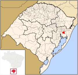
| Location of Gravatai in Rio Grande do Sul | ||
Gravataí is a Brazilian city in the southernmost Brazilian state of Rio Grande do Sul northeast near Porto Alegre .
The city, founded in 1763 and one of the fastest growing in the country, has (2018) an estimated 279,398 inhabitants on 498 km². It is named after the Gravataí river , which in Tupí-Guaraní karagwa'ta , describes a pineapple- like bromeliad species that is common along the river.
Gravataí has good transport links. The distance to Porto Alegres airport is 20 kilometers.
There is a General Motors do Brasil plant , which is where the Chevrolet Celta is built . There are also a number of suppliers, including Johnson Controls .
Nearby cities are Novo Hamburgo , Taquara , Glorinha , Viamão , Alvorada , Porto Alegre , Cachoeirinha , Canoas and Sapucaia do Sul .
Web links
- Prefecture of Gravataí (Portuguese)
- Page of the Chamber of Commerce (Portuguese)
- Sogil: Gravataís bus system with timetable (Portuguese)


