Schlossstrasse (Dresden)
| Schlossstrasse | |
|---|---|
| Street in Dresden | |
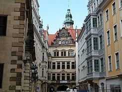
| Schloßstraße / corner of Kanzleigässchen | |
| Basic data | |
| place | Dresden |
| District | Inner old town |
| Created | 15th century |
| Newly designed | from 1950 and from 2009 |
| Connecting roads | Wilsdruffer Strasse |
| Cross streets | Taschenberg, Jüdenhof |
| Places | Altmarkt , Schloßplatz |
| Buildings | Residenzschloss , Kulturpalast |
| use | |
| User groups | Pedestrian traffic , bicycle traffic |
| Road design | Trees and historic candelabras are planned |
The Castle Road runs in the Dresden old town by the Wilsdruffer street amounting northwest corner of the Old Market Square to Georgentor .
The street is part of an inner-city north-south axis, which starts at the main train station via Prager Strasse and Seestrasse to Schloßstrasse, after Schloßplatz crosses the Elbe on Augustusbrücke and continues on the Neustadt side over the Hauptstrasse to Albertplatz .
Surname
It was first mentioned as Elbgasse in 1402. Since 1572 it was called Schloßgasse and in 1858 it was renamed Schloßstraße.
history
Before industrialization , it was the city's main artery together with Wilsdruffer Straße. An exception was the period from the middle of the 16th century to the beginning of the 18th century, when traffic was diverted from the Augustus Bridge via Augustusstraße , Neumarkt and Große Frauengasse due to the closure of the Georgentor . The Dresden chronicler Johann Christoph Hasche described it as "one of the widest and liveliest streets" in Dresden at the end of the 18th century.

in the foreground the structure of the building on White Gasse 1–3
During the Dresden May uprising, Schloßgasse was the military headquarters of the rebels with a barricade under the command of Stephan Born . A bronze plaque made by Martin Hänisch commemorates the May uprising on the building at Schloßstraße 7 . Further memorial plaques for the May Uprising can be found on the Altmarkt and the Dresden Armory .
In February 1945 during the air raids on Dresden , the street and its buildings were destroyed. Reconstruction began in the 1950s.
Around 2010, as part of the reconstruction of the Neumarkt area, the further reconstruction of the eastern development of Schloßstraße began, in which the parallel and side streets, which were also destroyed in 1945, were rebuilt. Between the Kanzleigässchen at the castle and the Rosmaringasse at the Kulturpalast , the Sporergasse connects the Schloßstraße with the Jüdenhof . To the north of Sporergasse is the partially rebuilt Neumarktquartier VIII (as of January 2014), to the south of it Quartier VII . Schössergasse runs parallel to Schloßstraße and divides both quarters again.
Back streets
Recreating back roads
Rosmaringasse
This lane ran as an extension of the Große Brüdergasse, which is now built over, to Galeriestraße. Around 1600 the initially nameless street was called Niclaßgasse , Petergeßlein and Quergässlein . It had been called Rosmaringasse since the end of the 17th century because it was used to offer rosemary twigs to the mourners moving to the Frauenkirchhof .
Sporergasse
The Sporergasse was the connection to the Schössergasse and ended in the Jüdenhof . It was first mentioned in 1602. The name refers to the spurs , craftsmen who lived in the alley and made spurs and riding gear.
Chancellery
The Kanzleigäßchen runs south of the eponymous office building to Schössergasse. The alley was first mentioned in 1413 and in 1633 referred to as "gäßchen an der cantzlie". From 1565 to 1567, Hans Irmisch built the chancellery on behalf of Elector August .
With the rebuilding of the chancellery house 1997–1999 by the diocese of Dresden-Meißen , premises for the house of the cathedral were created not far from the Catholic Court Church .
Schössergasse
Schössergasse is a small parallel street to Schloßstraße, it runs from Wilsdruffer Straße to Kanzleigäßchen. In 1396 it was first mentioned as "Yodingasse" (Judengasse). In addition to the Jüdenhof, it was the place of residence for the Dresden Jews until they were expelled in 1430. After 1563 it was called "Niclaßgasse" or "Große Niclaßgasse". Since 1589 it has been known as Schössergasse, as the district governor Ambrosius Ernst lived here.
Grosse and Kleine Brüdergasse
The Große Brüdergasse is a side street of the Schloßstraße that existed until 1967. It was built over in 1967 when the old town was rebuilt by the so-called " eating cube ". Parts of the Kleine Brüdergasse are still preserved today at the Taschenbergpalais . Both streets are named after the religious of the Franciscan monastery , which was at the end of the streets. The Große Brüdergasse was mentioned in 1362 as "Große Brudirgasse" and the Kleine Brüdergasse in 1370 as "perra platea minor" and in 1396 as "wenynge Brudirgasse". During the Dresden May uprising, there was a barricade on the Quergäßchen between the two streets and one at the exit to Schloßstraße.
Development
In addition to residential and commercial buildings, there were numerous traditional buildings on the street. These included the court pharmacy, the residence of the Saxon court preachers of the 17th and 18th centuries, the hotels Stadt Gotha and Hotel de Pologne and the eponymous residential palace with the chancellery . In the course of time, adjacent residential buildings were removed for the expansion of the castle.
The Polish composer Frédéric Chopin stayed at the Hotel Stadt Gotha during a stay in Dresden . A bronze plaque commemorates this at Schloßstraße 5. The portrait relief was created in 1985 by Wilhelm Landgraf , the accompanying lettering comes from Martin Hänisch. The board is 90 by 42 centimeters in size.
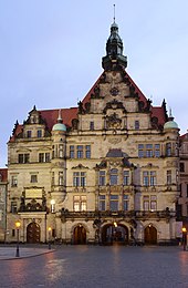
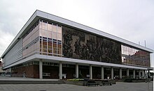
Today the southern part of Schloßstraße is bordered on the east side by the Kulturpalast . On the west side there are residential and commercial buildings. The northern part is surrounded by castle buildings.
Hotel de Pologne
The Hôtel de Pologne was on the corner of Große Brüderstraße. In the 16th century, the Chancellor Nikolaus Krell lived in one of the previous buildings. An inn was operated in the house since 1696. Samuel Locke rebuilt it in 1767 and united it with the neighboring house. The Hôtel de Pologne was one of the finest hotels in Dresden. From 1869 Karl Eberhard redesigned the building for the Saxon Bank in Dresden .
literature
- Stadtlexikon Dresden A-Z . Verlag der Kunst, Dresden 1995, ISBN 3-364-00300-9 .
- Art in public space . Information brochure of the state capital Dresden, December 1996.
Footnotes
- ↑ The Chancellery. Gesellschaft Historischer Neumarkt Dresden , accessed on July 8, 2018 .
- ↑ House of the cathedral dedicated . In: Day of the Lord . No. 13 , April 4, 1999 ( online ).
Web links
Coordinates: 51 ° 3 ′ 6.2 ″ N , 13 ° 44 ′ 15.2 ″ E


