Seestrasse (Dresden)
| Seestrasse | |
|---|---|
| Street in Dresden | |
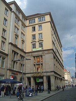
| Café Prague on Seestrasse, 2011 | |
| Basic data | |
| place | Dresden |
| District | Inner old town |
| Hist. Names | Seegasse |
| Connecting roads |
Schloßstraße , Prager Straße |
| Cross streets |
Webergasse , Kramergasse, Zahnsgasse, An der Mauer, Dr.-Külz-Ring, Waisenhausstrasse |
| Places | Old market |
| Buildings | Seestrasse 2–16 |
| use | |
| User groups | Pedestrian traffic , bicycle traffic , motor traffic |
| Technical specifications | |
| Street length | 240 meters |
The lake road is a road in the center of Dresden . It is located in the inner old town ( district Old Town I ).
course
Seestrasse begins in the southwest corner of the Altmarkt and leads south to the Dr.-Külz-Ring / Waisenhausstrasse traffic train , where it turns into Prager Strasse . The continuation north of the Altmarkt is the Schloßstraße .
traffic

The narrow sea road plays a negligible role for motor traffic . There is hardly any through traffic ; delivery traffic for adjacent shops is more frequent . As part of the downtown promenade from Dresden Central Station on Wiener Platz via Prager Strasse, Altmarkt, Schloßstrasse, Augustusbrücke and Hauptstrasse to Albertplatz, there are many pedestrians on Seestrasse.
layout
The lake road was of historic granite - paving provided. Your footpaths consist of granite slabs or paving stones. It is not green. A special feature are the seven showcases (showcases) set up in front of Seestrasse 12-16 for advertising purposes in the 1950s . They are under monument protection (see list of cultural monuments in Old Town I (Dresden) ). In June 2011 Franka Hörnschemeyer's work of art “Trichter” was inaugurated. It consists of a staircase that leads to a platform under Seestrasse, from where one can see a canal of the city drainage through a curved pane of glass.
Development
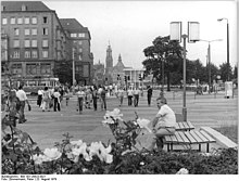
On the west side of Seestrasse - north of Dr.-Külz-Ring - is the 300-meter-long building complex Altmarkt 21-25 / Seestrasse 2-16 , which ends in the Centrum department store on the corner of Wilsdruffer Strasse . These residential and commercial buildings with shop areas in closed development are protected as cultural monuments. The row of houses was built at the original address Altmarkt 13-25 from 1953 to 1958 based on designs by the architects Johannes Rascher , Gerhard Guder and Gerhard Müller. The buildings on Seestrasse 8 and 10 with the Café Prague protrude from the front of the building almost to the edge of the Seestrasse. The footpath runs beneath them like an arcade . To the north of this are arcades on the ground floor , behind which shops are housed. Based on the Dresden building tradition, the seven-storey buildings were given a sandstone plaster facade. They were executed in the style of socialist classicism , which historically quotes the Dresden Baroque . Directly behind them, on their courtyard side, is the Altmarkt-Galerie shopping center, which opened in 2002 and into which the old Centrum department store, among other things, was integrated by 2011.
In the northern part of the east side of the Seestrasse, between Altmarkt and Kramergasse, there is the Altmarkt 10 office building , a building constructed in 1999/2000 according to plans by Gerkan, Marg and Partners . In particular because of its step-like roof, but also because of the factual, strict, angular appearance, the people call the building the " Lego House ". An arcade with massive pillars stretches along Seestrasse over the ground floor and first floor. South of Kramergasse, the arcade continues in the neighboring building, a C&A department store opened in 1998 based on a design by the Essen office of Nattler Architekten with the address Seestraße 7. It extends to the street An der Mauer. To the south of this is the west side of the Dr.-Külz-Ring 15 office building.
history
The original name of the traffic route, first mentioned in 1324, was Seegasse. It is named after the old pond / lake, also known as the upper lake. This body of water lay in the Seegraben and was probably drained as early as the beginning of the 16th century. It was also the namesake of the Seetor, the Oberseer community and finally also the Seevorstadt district , which emerged from this community and extends from the Annenkirche to the Bürgerwiese .
The See- and Elbgasse (today Schloßstraße) formed the only straight and continuous traffic route in Dresden. However, the section along the Seegasse in particular remained insignificant for a long time. The sea gate at its southern end, first mentioned in 1403, was part of the Dresden fortifications and was bricked up in 1550 due to the lack of capacity. Melchior Trost converted his tower into a prison. It was not opened again until 1747/48 and redesigned according to plans by Johann Georg Maximilian von Fürstenhoff , after which the traffic on the Seegasse increased. The sea gate was demolished in 1821, as were the adjacent fortifications.
From around 1830, today's Seestrasse was then called Innere Seegasse. The section of today's Waisenhausstraße between Prager Straße and Dippoldiswalder Platz was called Äussere Seegasse . Already in 1840 the Äußere Seegasse was added to the Waisenhausstraße, whereupon the Innere Seegasse got its original name again. Since 1858 it has been called Seestrasse.
The Seestrasse was densely built up as part of the historic city center . Well-known owners of houses on the street were Hans Haubold von Einsiedel , George Bähr and Ludwig Christoph von Burgsdorff , where Goethe was twice a guest in 1813 . The banking house Gebrüder Arnhold had its seat there from 1873 to 1878. In 1903 the Bismarck monument by Robert Diez , which was destroyed in 1945/46, was erected near the southern end of Seestrasse . Around 1900 the decision was made to widen Seestrasse due to the increased volume of traffic, which necessitated the demolition of some buildings, including the Besser House on the corner of the Altmarkt. The Kino Zentrum-Lichtspiele was also built at Seestrasse 11/13 in 1926, for which four houses were demolished.

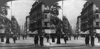
Seestrasse before the air raids of 1945, in the background the tower of the Catholic Court Church, 1906 ( stereoscopy )
|
Saul's house formed the south-western end of the street directly at the rampart wall . Erected for the Saul Legation Councilor in 1752/53, it is considered the last work by Johann Christoph Knöffel . It stood south of the alley An der Mauer, which at that time also continued west of Seestrasse, on its south side a park was added after the demolition of the fortifications. It temporarily served as a ministerial hotel. In 1924 it was converted into the Saxon State Bank according to plans by Oskar Pusch . Like all other buildings on Seestrasse, it was destroyed in the devastating air raids on Dresden in February 1945, and the rubble was cleared from the ruins in the following years. The town planners of the early GDR era doubled the area of the Altmarkt to the south, so that the eastern side of the Seestrasse remained undeveloped until around the year 2000. The rebuilding on the west side of the Seestrasse took place in the 1950s. However, the row of buildings created there was originally called Altmarkt 21–25 / Seestraße 2–16, Altmarkt 13–25; According to its name, Seestrasse did not exist at that time and was added to the Altmarkt as urban space.
literature
- Stadtlexikon Dresden A-Z . Verlag der Kunst, Dresden 1995, ISBN 3-364-00300-9 .
Web links
Individual evidence
- ↑ Exciting insights at the Seetor - in the middle of the city: the work of art “Trichter” is inaugurated. In: dresden.de. State capital Dresden, June 23, 2011, accessed on February 9, 2017 (press release).
- ↑ das-neue-dresden.de: Commercial Building Market Square. Retrieved March 22, 2013.
- ^ A b Adolf Hantzsch: Name book of the streets and squares of Dresden. In: Communications of the Association for the History of Dresden , Hefte 17/18, Verlaghandlung Wilhelm Baensch, Dresden 1905, p. 133 f.
- ^ Fritz Löffler : The old Dresden - history of its buildings . EA Seemann, Leipzig 1981, ISBN 3-363-00007-3 , p. 22 .
- ^ Fritz Löffler : The old Dresden - history of its buildings . EA Seemann, Leipzig 1981, ISBN 3-363-00007-3 , p. 264 .
- ^ Fritz Löffler : The old Dresden - history of its buildings . EA Seemann, Leipzig 1981, ISBN 3-363-00007-3 , p. 500 .
Coordinates: 51 ° 2 ′ 54 ″ N , 13 ° 44 ′ 12 ″ E


