Great Eschenheimer Strasse
| Great Eschenheimer Strasse | |
|---|---|
| Street in Frankfurt am Main | |
| View from the main guard | |
| Basic data | |
| place | Frankfurt am Main |
| District | Downtown |
| Created | around 1333 |
| Hist. Names | Great Eschenheimer Gasse |
| Connecting roads | At the Hauptwache (south), Eschenheimer Tor (north) |
| Cross streets | Zeil , Stiftstrasse |
| Buildings | Kaufhof Zeil , Palais Thurn und Taxis |
| Technical specifications | |
| Street length | 270 m |
The Große Eschenheimer Straße , until around 1860 Große Eschenheimer Gasse , is an important downtown street in Frankfurt am Main . It connects the center of the Neustadt , the Hauptwache , with what was once the most representative city gate of the Frankfurt city fortifications , the Eschenheimer Tor located around 400 meters to the north .
location
Große Eschenheimer Straße is located in the shopping area of downtown Frankfurt. At Hauptwache she meets the Zeil , the city's largest shopping street. The Hauptwache itself can be seen today as the center of Frankfurt due to its location and its rapid transit junction . To the west, parallel to the Große Eschenheimer, runs Schillerstrasse , the seat of the Frankfurt Stock Exchange and a pedestrian zone.
Until February 2009, the Große Eschenheimer Straße had three lanes of motor vehicles and was a one-way street in a northerly direction. In the course of the closure of the Hauptwache for motor vehicles, however, the traffic routing on Große Eschenheimer Straße was changed. Now the street is also operated in two-way traffic, with only one entrance to Biebergasse being possible to the south. The direct connection to the Roßmarkt is only possible as a pedestrian. Today the street is primarily intended as a feeder for the new MyZeil car park .
Beyond the Eschenheimer Tor, today a major traffic junction for car traffic, the Große Eschenheimer Straße turns into the Eschersheimer Landstraße , and the Oeder Weg branches off to the east .
history

( steel engraving by Wilhelm Lang based on a model by Jakob Fürchtegott Dielmann )
The street was created in connection with the establishment of the Neustadt after the city expansion in 1333. From the previous north-western city gate, the Bockenheimer or Katharinenpforte and the present-day Hauptwachenplatz, a street was laid to the new northern city entrance, the Eschenheimer Tor. It is named in city maps until around 1860 as Große Eschenheimer Gasse , a term that was used in language and in literature until well into the 20th century.
After heavy destruction in 1944 in the Second World War due to the air raids on Frankfurt am Main , the street was rebuilt considerably wider to make room for car traffic. The facts created at that time are currently being revised, so the traffic in the street should be calmed, while the partially high-quality architecture of the reconstruction is falling victim to new building projects.
On November 26, 1964, the street was transformed into a deep excavation pit for several years, due to the open-cut A-route of the Frankfurt underground . The reward for the effort is now an optimal underground and S-Bahn development through underground stations at both ends of the street, the Hauptwache and Eschenheimer Tor stations .
Buildings
The most important building on the street stands at its end: the Eschenheimer Tower , the actual former city gate, still dominates the street scene today. The tower, built in the 15th century, is one of the city's landmarks.
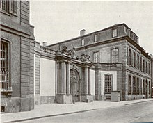
No less important was the Palais Thurn und Taxis ( Robert de Cotte ), built between 1729 and 1739 , which served as the seat of the German Bundestag from 1815 to 1866 and was destroyed in 1944 by air raids. Its ruins were torn down in 1951 to make room for a new landmark: the telecommunications high-rise (1954, Heinrich Ebert ) belonged to the first generation of Frankfurt high-rises and, with its cantilevered roof and the post transmitter systems attached to it, offered an impressive picture.
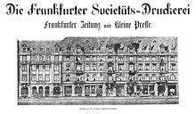
At the northern end of the street was the Rundschau-Haus ( Wilhelm Berentzen ) built in 1953 , the seat of the daily newspaper Frankfurter Rundschau . The Große Eschenheimer Straße has a tradition as a newspaper street, and the Frankfurter Zeitung also had its editorial office here (diagonally opposite).
The telecommunications high-rise was demolished in 2004 and the Rundschau-Haus in 2006 in order to completely rebuild the block between Zeil, Großer Eschenheimer Straße and Stiftstraße: The MyZeil shopping center , which opened in 2009, was built as part of the large-scale Palais Quartier project , as well as two high-rise buildings, the 136-meter-high Nextower and the 96 meter high Jumeirah Hotel, as well as a simplified reconstruction of the Palais Thurn und Taxis.
One of the largest department stores in the republic, Kaufhof an der Hauptwache (formerly Tietz ) is on the corner of the Zeil at the southern end of the street. The department store, rebuilt in 1949/50, first opened with three floors, was increased to five in 1954, and now offers goods on eight floors. The basement goes directly into the underground station.
Surname
The objects named after the Eschersheim district have two different spellings in Frankfurt. This is not a typo, but a well-known curiosity:
- All objects within the ramparts are written “Esche n heimer” (with n ): Eschenheimer Turm, Eschenheimer Tor, Große and (the former, no longer existing) Kleine Eschenheimer Straße, Eschenheimer Anlage;
- All objects outside the ramparts are written “Esche rs heimer” (with rs ): Eschersheimer Landstrasse, Frankfurt-Eschersheim, Alt-Eschersheim.
The streets leading from the central squares of Neustadt to the gates have the prefix “Große” in Frankfurt, such as the Große Gallusstraße , the Große Bockenheimer Straße , the Große Friedberger Straße or the Große Eschenheimer. There was also a Kleine Eschenheimer Strasse , which branched off halfway east from the large one and led to Stiftstrasse . When it was rebuilt after the Second World War, it was built over.
literature
- Fried Lübbecke : The face of the city. Based on Frankfurt plans by Faber, Merian and Delkeskamp 1552–1864 . Waldemar Kramer Verlag, Frankfurt am Main 1983, ISBN 3-7829-0276-9 .
Web links
- Great Eschenheimer Strasse. altfrankfurt.com
swell
- ↑ Stadtvermessungsamt Frankfurt am Main (ed.): Portal GeoInfo Frankfurt , city map
- ↑ Hauptwache closed to cars , Frankfurter Rundschau from February 19, 2009
Coordinates: 50 ° 6 ′ 55 " N , 8 ° 40 ′ 46.3" E


