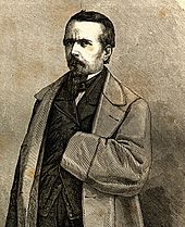
Guillaume Lejean
Guillaume Lejean (* 1828 in Plouégat-Guérand , Département Finistère ; † February 1, 1871 ibid) was a French geographer and explorer .
Life
Guillaume Lejean was the son of a landowner, was educated in the spiritual seminary at Saint-Pol-de-Léon and, at the age of 17, appeared in the Journal de Morlaix with a paper on the Origines Bretonnes . After he had been a prefectural official in Morlaix for a while, he went to Paris for further scientific training , where he continued the historical studies of his native province, as before in his post in Morlaix. As a result, he published the work Histoire politique et municipale de la ville et de la communauté de Morlaix (Morlaix 1847) and La Bretagne, son histoire et ses historiens (Paris 1850). Then he turned to the study of geography . Since 1856, when he became a member of the Paris Geographical Society, he published various geographic works in its bulletin and in Petermann's Geographische Mitteilungen and other journals.
Lejean's plan for a trip to the interior of Australia , with which he had already borne himself in 1848, had not been carried out, and so he started his career as an explorer in 1857 in the same field to which he later devoted most of his time, European Turkey. Through protection, he was entrusted by the French government with the task of carrying out topographical, historical and ethnographical research on the Balkan Peninsula . On six-year journeys in 1857, 1858 and 1867 to 1870, he collected material for a large series of maps of the Balkan Peninsula in 49 sheets, of which he left 20 completed. Apart from a few smaller works, however, of his Turkish researches, only the ethnography of European Turkey has been published because it was interrupted by several extended trips to Africa and Asia ; it appeared in Gotha in 1861 in the fourth supplement to Petermann's Geographische Mitteilungen in French and German.
In order to fulfill a long-cherished wish, Lejean embarked on a journey to the upper Nile countries in 1860 , came to Khartoum via Suakim , visited Kordofan and traveled the White Nile to Gondokoro and the Bahr al-Ghazal , of which he was the first usable Map drew. Lejean returned to Paris in 1861 with rich collections that were important for knowledge of the Nile countries. He reported mostly on these and the following trips in the bulletin of the Paris Geographical Society and in other journals. Appointed French consul of Massaua and Abyssinia in 1862 , he became involved in the conflict between King Theodorus and the Europeans, was taken prisoner and, after months of internment in Hassat, was expelled from the country in September 1863. After a trip to the north of Abyssinia to Kassala and the Bogosländer , he returned to Paris in 1864, where he wrote his Voyage aux deux Nils, exécuté de 1860-64 (Paris, 1865-68, with Atlas) and Théodore II, le nouvel empire d'Abyssinie et les intérêts français dans la Sud de la mer Rouge (Paris, 1865) wrote.
At the end of 1865 Lejean went on a trip to Asia Minor , Mesopotamia and the countries on the Indus as far as Kashmir , but had to give up the plan to advance from there to Bukhara . From 1867 he then continued his research in European Turkey, the conclusion of which was prevented by his death on February 1, 1871 in his birthplace Plouégat-Guérand.
literature
- Guillaume Lejean . In: Meyers Konversations-Lexikon . 4th edition. Volume 10, Verlag des Bibliographisches Institut, Leipzig / Vienna 1885–1892, p. 676.
Web links
- Literature by and about Guillaume Lejean in the catalog of the German National Library
- Jules Verne: Five weeks in a balloon, fourth chapter, exploration trips in Africa from projekt-gutenberg.org
| personal data | |
|---|---|
| SURNAME | Lejean, Guillaume |
| BRIEF DESCRIPTION | French geographer and explorer |
| DATE OF BIRTH | 1828 |
| PLACE OF BIRTH | Plouégat-Guérand |
| DATE OF DEATH | February 1, 1871 |
| Place of death | Plouégat-Guérand |

