
Hans Conrad Gyger


Hans Conrad Gyger (born July 22, 1599 in Zurich ; † September 25, 1674 there ; authorized to live there ) was a Swiss cartographer and engineer .
Life
Gyger was the son of the glazier Hans Georg Gyger and his wife Elisabeth Meyer von Herisau . Gyger received an apprenticeship as a glass painter from Christoph Nüscheler . In 1619 he became quartermaster and was a member of the Meisen guild .
Cartographic work
Gyger published several maps of the Canton of Zurich and Switzerland. Ten maps of the Zurich landscape were drawn up between 1644 and 1660, on which the troop assembly areas and their catchment areas are shown.
At the same time he was working on a large hand-painted relief map of the canton (230 × 225 cm) on behalf of the Zurich government. It was completed in 1667 after 38 years of work. The map on a scale of 1: 32,000 is considered a masterpiece of three-dimensional terrain representation. Gyger was the first to depict a landscape in this way. It was common then and for a long time afterwards to depict hills and mountains on maps from a gentleman's perspective. Because the map was subject to military secrecy, his pioneering work had no direct impact on other cartographers. In the course of the 18th century the "Gyger map" was redrawn.
The Swiss cartographer Eduard Imhof praised Gyger and his work in the monthly “Atlantis” in 1944 as follows: “This map not only towers above all other Swiss maps of the 17th and 18th centuries, it also had none abroad at its time Rival. Yes, you can say that it has not been surpassed anywhere except for our day in the picturesque immediacy of the landscape. "
In July 2012, the Zurich Central Library was able to bid for a map of the upper Lake Zurich that had been lost for centuries . The 35 by 57 centimeter map of the upper Lake Zurich was previously only known from a Gyger catalog raisonné. The original was made around 1635 and originally served official purposes.
In addition to his work as a map painter , Gyger also worked as a glass painter.
Gyger menu

Obersee region
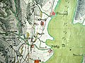
same section in the drawing

Detail of the Zurich region

Zurich- Oerlikon


Map of the upper Lake Zurich

In July 2012, the Zurich Central Library was able to bid for 9,000 francs in Zofingen, a map of the upper Lake Zurich that had been lost for centuries . The 30 by 57 centimeter map was previously only known from a Gyger catalog raisonné and two copies from the 18th century.
It was created around 1640 and illustrates a border dispute between the cantons of Zurich and Schwyz, which was negotiated between 1635 and 1643 at the Frauenwinkel near Pfäffikon SZ . The subject of the disputes was merchant shipping and the income from fishing; The Schwyzer had tried in vain to shift the borders in their favor. To represent the political separation, Gyger painted the Zurich areas in a light brown, the Schwyz area gray-green. In the 1920s, the map was drawn up on wood.
She appeared in the area around Aarau on an attic floor in the remains of a deceased elderly woman. It is not known how the latter came into possession of the card.
literature
- Eduard Imhof: Gyger, Hans Conrad. In: New German Biography (NDB). Volume 7, Duncker & Humblot, Berlin 1966, ISBN 3-428-00188-5 , p. 362 ( digitized version ).
- Samuel Wyder: Border and tithing plans by Hans Conrad Gyger (1599–1674). In: Cartographica Helvetica Heft 35 (2007) pp. 31–39 ( full text )
- Samuel Wyder: Boundary, tithe and fortification plans of the Zurich area by Hans Conrad Gyger (1599–1674) . Cartographica Helvetica, Murten 2006. (= Cartographica Helvetica special issue 18). ISSN 1422-3392
- Hans-Peter Höhener: Gyger [Geiger], Hans Conrad. In: Historical Lexicon of Switzerland .
Web links
- Thomas Klöti: Gyger, Hans Conrad. In: Sikart
- Literature by and about Hans Conrad Gyger in the catalog of the German National Library
- Various gyger cards from the Canton of Zurich Southwest (from the State Archives of the Canton of Zurich and the Zurich Central Library )
Individual evidence
- ↑ Maplan website
- ↑ Press release of the ZB (PDF) Illustration in the Tages-Anzeiger
- ↑ Tages-Anzeiger , July 19, 2012.
| personal data | |
|---|---|
| SURNAME | Gyger, Hans Conrad |
| BRIEF DESCRIPTION | Swiss cartographer and engineer |
| DATE OF BIRTH | July 22, 1599 |
| PLACE OF BIRTH | Zurich |
| DATE OF DEATH | September 25, 1674 |
| Place of death | Zurich |