Ports of Gernsheim
| Ports of Gernsheim | |||
|---|---|---|---|
| Data | |||
| UN / LOCODE | DE GHM | ||
| operator | Gernsheimer Hafenbetriebs- Gesellschaft mbH u. A. | ||
| opening | Antiquity / 1858 | ||
| Port type | Ports and Lands | ||
| Geographic information | |||
| place | Gernsheim | ||
| country | Hesse | ||
| Country | Germany | ||
| Port basin I Gernsheim | |||
| Coordinates | 49 ° 45 '21 " N , 8 ° 28' 49" E | ||
|
|||
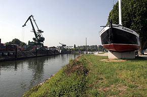
The ports of Gernsheim include two port basins for large shipping , a landing stage for passenger shipping ( Stromhafen ), two sport boat ports for recreational shipping , a ferry port and an industrial area. They are located at Rhine kilometers 461.7 to 462.6 in the west of the city of Gernsheim , Hesse on the Upper Rhine .
geography
The ports in Gernsheim are located on the right bank of the Rhine at several spatially separate locations west of the town center at an altitude of 87 m above sea level. NN .
- Rhine km 461.7 R: Gernsheim - Eich ferry port
- Rhine km 461.9 R: Gernsheim passenger shipping area
- Rhine km 462.1 R: Harbor basin I (large commercial shipping) and marina
- Rhine km 462.5 R: Harbor basin II (oil port)
Waibel Beton also operates its own factory premises and the Gernsheim Motor and Sailing Boat Club has a jetty at Rhine kilometer 466.0 L on Lake Eicher .
history
The Rhine was an important trade route between the North Sea and the Mediterranean as early as the Bronze Age , Hallstatt Age and Latène Age . There was rowing, sailing, stomping and trekking . In Roman times, the strategic importance for the Roman Rhine fleet was added. At that time there should have already been a port in Gernsheim. After the fall of the Roman Empire , navigation on the Rhine was maintained through all times and rafting was also carried out until the end of the 19th century .
The first of today's protective harbors with a basin separated from the river Rhine was built in Gernsheim in 1858. In 1869, a railway connection was created for the first time.
The facilities were partially destroyed in the Second World War . In execution of Hitler's Nero order (March 19, 1945), the neighboring Rhine bridge was blown up by German troops on March 20, 1945 .
The port facilities were rebuilt in the early 1950s. In 1953 the docks were restored to their present form. Since then, the preserved bunker of the bridge protection has been used by the water police who set up their station there. The bridge was not rebuilt.
Commerce and infrastructure
Today the commercial port facilities cover a total area of around 200 hectares . There are 0.8 km of quays available, 600 m of which are also connected to the port railway siding. This is operated by Gernsheimer Umschlags- und Terminalbetriebsgesellschaft mbH & Co KG . It connects the harbor with the Riedbahn . Trimodal cargo handling is possible in the ports of Gernsheim . In harbor basin I there is a container bridge and a semi-portal crane . Harbor basin II also has a gantry crane and facilities for handling liquids.
The ports in Gernsheim are the only Rhine ports in Hesse that will be comprehensively modernized over the next few years. The very narrow port entrances are currently being expanded. The construction work should be completed by 2017. 200 and 600 m downstream from harbor basin II are the unpaved areas required by the Waibel and SILIN companies, each of which has its own loading crane. The building materials company Waibel KG also holds 88 percent of the shares in Gernsheimer Hafenbetriebs-Gesellschaft.
The other port facilities have their own operators. The Gernsheimer Rheinfährbetrieb GmbH is responsible for the ferry operation and the sports boat harbor is managed at the club level.
traffic
The ports in Gernsheim are accessible to traffic via local roads leading to federal road 44 ; a branch track from Gernsheim station connects the rail traffic of the port railway with the railway line Mannheim – Frankfurt am Main (Riedbahn).
Web links
Individual evidence
- ↑ a b Gernsheim marina
- ^ History of the ports of Gensheim
- ↑ Railway Atlas Germany . 10th edition. Schweers + Wall, Cologne 2017, ISBN 3-921679-13-3 .
- ↑ Press report on the modernization concept
- ↑ Dieter Erlenbach: An important future investment. Lampertheimer Zeitung, February 7, 2017, accessed on June 23, 2018 (German).
- ↑ Gernsheim ferry


