
Höglwörther See
| Höglwörther See | ||
|---|---|---|

|
||
| Geographical location | Bavaria , Germany | |
| Tributaries | Höglwörther Seebach, Moosgraben | |
| Drain | Rauschbach → Ramsauer Bach → Sur | |
| Islands | Höglwörth (peninsula, former island) | |
| Places on the shore | Höglwörth | |
| Data | ||
| Coordinates | 47 ° 48 '57 " N , 12 ° 50' 33" E | |
|
||
| Altitude above sea level | 532 m above sea level NHN | |
| surface | 13.5 ha | |
| length | 523 m | |
| width | 414 m | |
| volume | 432,000 m³ | |
| Maximum depth | 6.40 m | |
| Middle deep | 3.2 m | |

The Höglwörther See (also: Klostersee) is a lake in the Höglwörth district of the municipality of Anger in the Berchtesgadener Land district . It is around 13.5 hectares in size and up to 6.4 m deep and is characterized as eutrophic . The Höglwörth monastery is located directly on the lake or on the (former) island of Höglwörth . Before silting up in the east, today's 2.2 hectare peninsula was an island ( Wörth is an old word for island), as can also be seen on the land map from the 19th century.
The lake was formed after the Saalach glacier melted about 10,000 years ago. Today it is subject to inexorable siltation . The Höglwörther See is a terminal moraine lake of particular geoscientific value and has been designated as a geotope by the Bavarian State Office for the Environment .
It offers the habitat of numerous animal species, such as pike , catfish , pikeperch , eel , carp , perch , tench , whitefish , ducks , coots and mute swans . The crabs that originally lived in the lake have already disappeared.
See also
Picture gallery

Höglwörth Monastery
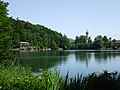
Höglwörther See with Höglwörth seaside resort and monastery

Pike in Höglwörther See

Sign at Höglwörther See


Web links
- The Höglwörther See on the website of the Traunstein Water Management Office, accessed on January 28, 2016
Individual evidence
- ^ Hermann and Anna Bauer: Monasteries in Bavaria. Munich 1985 , ISBN 3-406-37754-8 , p. 91
- ↑ Historical land map in the BayernAtlas
- ↑ Höglwörther See in the Bavarian geotope register , accessed on August 16, 2014