
Koenigs Wusterhausen harbor

The port of Königs Wusterhausen is an inland port in the Brandenburg city of Königs Wusterhausen .
location
The inland port is located in the districts of the city of Königs Wusterhausen and the municipality of Wildau and is in the immediate vicinity of the Schönefeld motorway junction and the planned Berlin-Brandenburg airport . It is part of the location development concept for the regional growth core Schönefeld / Königs Wusterhausen / Wildau and has connections to the Dahme waterway between kilometers 8.23 and 8.65 (Osthafen) and on both banks of the Notte Canal in the area where it joins the Dahme between kilometers 0 to 1.2. (North and South Harbor).
history
The first historical mention of a transshipment point on the Dahme took place in 1854. Mainly building materials were loaded and transported to Berlin . Around 1894, after the opening of the Berlin-Cottbus railway line , the port received a siding . After 1954 the port came into the hands of the city of Königs Wusterhausen before becoming part of the inland ports of Oder Eisenhüttenstadt in 1972 . From 1983 to 1987 the port was expanded extensively, in particular with tipping and crane systems for handling coal. Furthermore, a storage area for 200,000 tons of coal was created to supply the Klingenberg power plant in Berlin-Rummelsburg from here. In 1988 the port was then part of the inland port of Berlin . After 1990, LUTRA, Lager, Umschlag und Transport Mittelbrandenburgische Hafengesellschaft mbH , was founded as the new port operator , the sole shareholder of which is the city of Königs Wusterhausen. Coal handling ended on May 24, 2017, because the Klingenberg power plant was converted to natural gas firing.
Economic situation


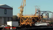
For transhipment between road / rail and water, two 20 ton luffing cranes are available in the north port, a 12.5 ton gantry crane and a truck tipping system as well as two wagon front wall tipping systems are available in the south port. The port railway with its nearly ten kilometers of track has a shunting locomotive Krauss-Maffei MH 05 , a shunting locomotive V60 and a two-way vehicle type Unimog .
The port has a theoretical annual handling capacity of five million tons. In 2013, the waterside transshipment amounted to 1,422,972 tons, while onshore the port area handled around 500,000 tons per year. Mainly building materials are received and coal (until 2017) and grain are sent. With the end of the shipment of lignite to the Klingenberg power plant, the throughput has been reduced significantly by 1.3 million tons.
| year | Reception in t | Shipping in t | Total in t |
|---|---|---|---|
| 2017 | 277.783 | 617.041 | 894.824 |
| 2015 | 313,000 | 1,363,000 | 1,676,000 |
| 2010 | 118.023 | 1,392,530 | 1,510,553 |
| 2005 | 188.841 | 1,592,966 | 1,781,807 |
| 2000 | 290,721 | 1,706,694 | 1,997,415 |
Web links
Individual evidence
- ^ Franziska Mohr: Farewell to coal . In: Märkische Allgemeine Zeitung . May 18, 2017 ( pressreader.com [accessed July 2, 2017]).
- ↑ Traffic report 2013 of the Wasser und Schifffahrtsdirektion Ost, p. 33 ( Memento from May 28, 2014 in the Internet Archive ) (PDF; 3.93 MB) accessed on May 27, 2014.
- ↑ New opportunities for the port. LUTRA GmbH, May 29, 2017, accessed on July 2, 2017 .
- ↑ Traffic report 2017 of the Directorate-General for Waterways and Shipping (PDF; 11 MB) accessed on June 27, 2019.
- ↑ Statistical report inland navigation in the state of Brandenburg 2015 (PDF; 4.4 MB) accessed on June 27, 2019.
- ↑ Traffic report 2010 of the Water and Shipping Directorate East
- ↑ Traffic report 2005 of the Wasser und Schifffahrtsdirektion Ost, p. 33 ( Memento from 7 July 2014 in the Internet Archive ) (PDF; 0.6 MB) accessed on 5 May 2013.
- ↑ Traffic report 2001 of the Wasser und Schifffahrtsdirektion Ost, p. 26 ( Memento of July 6, 2014 in the Internet Archive ) (PDF; 1.1 MB) accessed on May 4, 2013.
Coordinates: 52 ° 18 ′ 15.7 " N , 13 ° 38 ′ 16.1" E