
Dahme waterway
The Dahme-Wasserstraße (DaWanda) is a 26 km long federal waterway in the federal states of Berlin and Brandenburg . It begins north of the Schmöckwitz Bridge ( 52 ° 22 ′ 35 ″ N, 13 ° 39 ′ 17 ″ E ) and runs through the Zeuthener See , Sellenzugsee , Krimnicksee , Krüpelsee and Dolgensee to near Prieros ( 52 ° 13 ′ 24 ″ N, 13 ° 45 '48 "E ).
Between the kilometers 9.52 and 10.29 it is called Staabe (also rod).

Legally, the federal waterways also belong to the DaWanda: Wernsdorfer Seenkette, Möllenzugsee, estuary of the Notte, Zernsdorfer Lanke, Storkower and Teupitz waters. The Berlin Waterways and Shipping Office is responsible for the administration of the federal waterway .
Kilometrage
The kilometers of the waterway go uphill, against the direction of flow of the Dahme River in a predominantly south and south-east direction. It begins with the junction from the Spree-Oder waterway at kilometer 44. The border to the state waterway is at kilometer 26 northwest of Prieros, above the confluence of the Teupitz waters .
Locks
| place | Name of the lock | The fairway kilometer |
Data | Open to traffic year of construction |
image | Call channel phone no . |
Coordinates |
|---|---|---|---|---|---|---|---|
| King Wusterhausen | New mill lock |
Federal waterway DaWanda 9.50 |
L 38.93 m / W 5.33 m / drop height 1.50 m | 1868/1869 | 03375 293686 | 52 ° 17 ′ 50 "N, 13 ° 39 ′ 3" E | |
| Hermsdorf | Lock Prieros Hermsdorfer Mühle |
Landeswasserstraße Da 33.35 |
L 41.93 m / W 5.30 m / drop height 1.00 m | 1971 | 033764 245880 | 52 ° 9 ′ 56 ″ N, 13 ° 46 ′ 7 ″ E |
history
The section of the Dahme from Schmöckwitz to the Streganzer See near Friedersdorf was previously referred to as the Dahme waterway . The lower course of the river between Schmöckwitz and the confluence with the Spree in Köpenick has been part of the Spree-Oder waterway since 1890 . The Dahme waterway has been known as an inland waterway transport route for over 350 years. A first dam for a water mill was mentioned in 1478. This is the new mill near Königs Wusterhausen . A wooden lock was verifiably built around 1739 to bypass the mill jam for ships . The lock system at Prieros probably also dates from this time, as a new lock was built as early as 1808. In 1812 the Neue Mühle lock was replaced by a solid structure. Due to construction defects and heavy use, it wore out very quickly and was replaced by a new building in 1868/1869. In 1879 the Prieros lock was rebuilt. Mainly building materials such as wood and stones, fuel materials such as peat, brown and charcoal were transported on these waterways. Grain, beets and fodder for supplying the cities that will later be part of Berlin could also be transported inexpensively by water. For centuries, the most common type of ship was the coffee barge . A larger port was first mentioned in 1854 in connection with the transport of building materials to the developing residences in Berlin and Charlottenburg . In the course of the expansion of the Upper Spree and the construction of the Dahme flood canal from 1904 to 1911, a barrage with the Hermsdorf mill was built and a lock, the Hermsdorf lock, was built for ships with Finow dimensions . The port of Königs Wusterhausen developed into the largest port on the waterway . In 1972 the port was incorporated into the VE Kombinat inland shipping and waterways . In connection with "securing the supply of the Klingenberg power station on Rummelsburger See with lignite", the GDR had the port expanded from 1983 to 1987. Storage areas for coal as well as crane and wagon tipping systems were created.
Side waters
Federal waterways
Storkower waters

The Storkower Gewässer (SkG) flow into the Dahme waterway on the right at Prieros . They are 33.4 kilometers long and as a federal waterway belong to waterway class I. Beginning at the northern end of the Scharmützelsee , the second largest lake in the Mark Brandenburg, the Storkow waters run through the Wendisch Rietzer Fließ with the barrage (weir and lock) Wendisch Rietz (km 22.74) into the Storkower See and to the Storkow canal stage (km 15.48) at the beginning of the nine-kilometer-long Storkower Canal with the further Kummersdorf canal stage (km 10.25). Then the Wolziger See is reached. The waterway then leads in a westerly direction through the Blossiner Fließ to the Langen See and into the Dahme waterway at kilometer 25.00.
The Storkower Flößerkanal was laid out as early as 1732 for the removal of the timber in the direction of Berlin , but with a slightly different route than the Storkower Canal , built in 1746 between the Great Storkower See and the Wolziger See . At the same time, the almost two kilometer long Wendisch Rietzer Fließ between the Scharmützelsee and the Großer Storkower See was expanded like a canal (this section is sometimes referred to as the Storkower Canal in the literature) and widened and deepened in 1904. To overcome the height difference of approx. The Wendisch Rietz , Storkow and Kummersdorf locks serve 4.4 meters . The locks were rebuilt in Wendisch Rietz in 1807, in Storkow from 1825 to 1828 and in Kummersdorf in 1810. The Märkische Wasserstraßenverwaltung reported further construction activities on the waters and locks after 1850, which suggests the importance of the waterway. The Kummersdorf lock was replaced by a new building in 1862 and the canal sections were widened and deepened. The other locks were rebuilt between 1863 and 1865. The canals were again widened from 1892 to 1897.
After the Second World War there was increasingly no longer any need for freight shipping. From 2001 to 2003 the Storkow lock was replaced 150 meters below its previous location by a new building, namely as a self-service lock . The old lock from 1863 was demolished.
In the 1730s, parallel to or in front of the Storkower Canal, a raftsman canal was built over the Stahnsdorfer Fließ , Rieploser Fließ and the Lebbiner See into the Kolpiner Forest, although it only existed for a short time. This so-called "Upper Connection" was supposed to establish a connection from the Kolpiner Forest to the Storkower See, but failed due to the adverse terrain conditions at the Storkower Weinberg, a slope of today's Binnendüne Waltersberge nature reserve .
| place | Name of the lock | Waterways kilometer |
Data | Open to traffic year of construction |
image | Call channel phone no . |
Coordinates |
|---|---|---|---|---|---|---|---|
| Office Scharmützelsee | Wendisch Rietz lock | SkG 22.74 | L 34.00 m / W 5.30 m / drop height 1.27 m | 1863-1865 | .JPG) |
033679 215 | 52 ° 12 ′ 51 ″ N, 14 ° 0 ′ 14 ″ E |
| Storkow (Mark) | Storkow lock | SkG 15.48 | L 36.00 m / W 5.67 m / fall height 2.00 m | 1863–1865 replacement in 2003 |
_05.jpg) |
033678 404920 | 52 ° 15 ′ 30 "N, 13 ° 55 ′ 56" E |
| Kummersdorf | Kummersdorf lock | SkG 10.25 | L 34.25 m / W 5.65 m / drop height 1.17 m | 1862 |  |
033678 43322 | 52 ° 16 '6 "N, 13 ° 51' 53" E |
Teupitz waters
The so-called other inland waterway of the federal government, known as Teupitzer Gewässer (TpG), is a chain of lakes, connected by canals, which joins the Dahme waterway south of Prieros at kilometer 26, coming from a south-westerly direction. It is 18.30 kilometers long. From the southwest you can reach the Dahme over the Teupitzer See with the Mielitzsee , the Schweriner See , the Mochgraben , the Zemminsee , the Köriser Graben , the Schulzensee , the Großer Moddersee and the Kleiner Moddersee , the Klein Köriser See , the Hölzerner See , the Schmöldesee and the Huschtesee .
Landeswasserstraße
Notte
The Nottefließ was the first long waterway made navigable by humans in the Mark Brandenburg . The Notte joins the Dahme waterway on the left about one kilometer below the Neue Mühle lock . Its estuary is a so-called other federal inland waterway for a kilometer.
During the reign of the Elector of Brandenburg Joachim II , a navigability of the water is described in 1568. There were no locks there at that time. The reason for the expansion of the waterway was the gypsum deposits near Sperenberg . This gypsum was an important and sought-after building material and has been mined in the area since the 12th century. The Sperenberg gypsum quarries were the only ones of their kind in the Mark Brandenburg that could be mined. The hydraulic structures fell into disrepair during the Thirty Years' War . On the orders of the Great Elector , the waterway to the Mellensee was restored. During his reign, locks were built in Mellensee, Mittenwalde and Königs Wusterhausen. According to Berghaus, these locks were replaced by new buildings in 1818. From 1856 to 1864 the waterway was gradually expanded in order to improve the conditions for freight shipping at the time. Paved towpaths were created. In 1960 the Mittenwalde lock was renewed and the Königs Wusterhausen lock rebuilt in 1983/84. Due to the low bridges and the resulting low headroom for more modern ships, the Notte lost its economic importance for freight transport at the end of the 1980s.
| place | Name of the lock | Waterways kilometer |
Data | Open to traffic year of construction |
image | Call channel phone no . |
Coordinates |
|---|---|---|---|---|---|---|---|
| At the Mellensee | Mellensee lock | Notte 21.90 | L 40.00 m / W 5.20 m / drop height 2.00 m | 1818/1819 |  |
033764 245880 | 52 ° 11 ′ 16 "N, 13 ° 24 ′ 37" E |
| Mittenwalde | Mittenwalde lock | Notte 9.30 | L 40.00 m / W 5.20 m / drop height m | 1818/1819 new 1960 |
 |
033678 4049-22 | 52 ° 15 ′ 27 ″ N, 13 ° 32 ′ 5 ″ E |
| King Wusterhausen | Lock Koenigs Wusterhausen | Notte 1.80 | L 40.00 m / W 5.20 m / drop height m | 1818/1819 new 1983/1984 |
 |
033678 4332222 | 52 ° 17 ′ 48 "N, 13 ° 37 ′ 27" E |
photos

Schmöckwitz, aerial view

Schmöckwitz road bridge

Motorway bridge A 10
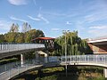
Niederlehme foot and cycle bridge

Sheep bridge at Wendisch Rietz


See also
literature
- Hans-J. Uhlemann: Berlin and the Märkische waterways . DSV-Verlag, Hamburg 1994.
- Writings of the Association for European Inland Shipping and Waterways e. V. various years. Western European shipping and port calendar, Binnenschifffahrts-Verlag, Duisburg-Ruhrort OCLC 48960431
- Folke Stender: Editing of Sportschifffahrtskarten inland 1 . Nautical Publication Verlagsgesellschaft, ISBN 3-926376-10-4 .
- Heinrich Berghaus: Land book of the Mark Brandenburg . Volumes I – III, Brandenburg 1854/1856.
Web links
- Map of the Berlin waterways with the Dahme waterway (PDF; 988 kB)
Individual evidence
- ↑ a b c d e Lengths (in km) of the main shipping lanes (main routes and certain secondary routes) of the federal inland waterways ( Memento of the original from March 3, 2012 in the Internet Archive ) Info: The archive link was automatically inserted and not yet checked. Please check the original and archive link according to the instructions and then remove this notice. (PDF; 81 kB), Federal Waterways and Shipping Administration
- ↑ a b c List of federal inland waterways serving general traffic. Federal Waterways and Shipping Administration, accessed on February 10, 2020 .
- ↑ a b c d Directory F of the Chronicle ( Memento of the original from July 22, 2016 in the Internet Archive ) Info: The archive link was inserted automatically and has not yet been checked. Please check the original and archive link according to the instructions and then remove this notice. , Federal Waterways and Shipping Administration
- ^ The Neue Mühle lock at the WSA
- ^ State of Brandenburg. State Office for Building and Transport (LBV): locks . Dahme waterway (lock Prieros Hermsdorfer Mühle)
- ^ Heinrich Berghaus: Landbuch der Mark Brandenburg , Volumes I – III. Brandenburg 1854/1856
- ↑ Reference to the construction of the Dahme flood canal
- ↑ Picture of the Hermsdorfer Schleuse ( memento of the original from August 21, 2014 in the Internet Archive ) Info: The archive link has been inserted automatically and has not yet been checked. Please check the original and archive link according to the instructions and then remove this notice.
- ↑ Guide on the German Shipping Roads , 4th part; The shipping routes between the Elbe and Oder . Published by the Reich Ministry of Transport, Berlin 1940
- ↑ Teupitz Waters WSA
- ↑ Märkische Allgemeine Zeitung , October 26, 2009 (PDF; 804 kB)