
Kummersdorf (Storkow (Mark))
|
Kummersdorf
City of Storkow (Mark)
Coordinates: 52 ° 16 ′ 19 ″ N , 13 ° 51 ′ 57 ″ E
|
||
|---|---|---|
| Height : | 35 m above sea level NHN | |
| Residents : | 507 (Jan. 1, 2013) | |
| Incorporation : | October 26, 2003 | |
| Postal code : | 15859 | |
| Area code : | 033678 | |
Location of Kummersdorf in Brandenburg |
||
_02.jpg) |
||

Kummersdorf ( Lower Sorbian Komorow ) is a district of the small town of Storkow (Mark) in the Oder-Spree district of Brandenburg . With around 500 inhabitants, the village, which was incorporated in 2003, is the most populous of the 14 districts of Storkow. The village, first mentioned in a document in 1442, is located in the Dahme-Heideseen nature park and is traversed by the Storkower Canal , which connects the Großer Storkower See with the Wolziger See .
geography
Natural area and location
Kummersdorf is located south of the Berlin glacial valley, through which the Spree flows, and west of the Storkower Platte in the East Brandenburg heath and lake area , which is listed as No. 82 in the main natural areas of Germany . The numerous lakes in the area are a relic of the Brandenburg stage (24,000 to 22,000) of the Vistula Ice Age . About two kilometers to the west is the Wolziger See with the place Wolzig , which belongs to the neighboring municipality of Heidesee . To the northeast, about two kilometers away, follows the Storkow district of Alt Stahnsdorf and to the east is the district of Storkow Rieplos . The core city of Storkow is around five kilometers to the east. In the south, the districts of Storkow, Philadelphia and Görsdorf, border on the Kummersdorfer district.
In the extreme northeast on the border with Rieplos, the district of Kummersdorf includes a section of the Rieplos river . In the north-west, the Kummersdorf district encompasses part of the Storkower Canal nature reserve , which includes the Stahnsdorfer Fliess and is intended to preserve wild plant communities, forest communities and animal species in the muddy lowland between Wolziger and Stahnsdorfer See . These include tall herbaceous corridors and crab claw corridors and endangered species such as otters , asp and bitterling . The area is also designated as an FFH area in the Natura 2000 network .
Transport links
The main traffic artery of the village is Landesstraße 40 ( Kummersdorfer Hauptstraße ), which cuts through the town from west to east and connects to Wolzig and via the L 23 to Storkow. The bridge over the canal was completely rebuilt from May 27, 2013 to April 10, 2014 in record time. This replacement building was necessary because the structure from the 1960s, which is part of the diversion of the BAB 12, was very badly damaged. There is also a connection in Kreisstraße 6748 to Alt Stahnsdorf and to the Storkow junction of the federal motorway 12 , which is located just north of Alt Stahnsdorf, and which is part of Neu Stahnsdorf , which leads from the Berliner Ring to Frankfurt (Oder) . In local public transport, line 406 of Busverkehr Oder-Spree (BOS) links Kummersdorf with Storkow and Wolzig, but only on weekdays and around eight times a day. With its own train station or stop , Kummersdorf is an exception among the districts of Storkow. The stop is part of the NEB- operated railway line from Königs Wusterhausen to Frankfurt (Oder) ( RB 36 , including via Storkow, Beeskow , Müllrose ).
The Storkower Canal, expanded from the Flößergraben to a canal under the reign of Frederick II in the second half of the 18th century , is part of the 33.44-kilometer-long Storkower Gewässer (SkG) federal waterway from Scharmützelsee to Dahme . For centuries, in particular for supplying Berlin with timber used is its present traffic economic importance largely in the field of leisure - and tourism industry . As a rule, it is only used by passenger ships , pleasure boats and for water hikes .
history
First mention and naming
As far as is known, Kummersdorf was first mentioned in 1442 under the name Lumersdorf (read: Kumersdorf ) as a village with a mill. 1463 is the name Cummersdorff . The name derivation is unclear. The official website of the city of Storkow traces the name in the description of the district back to the personal name Komor or Kummer , which may have been the founder of the village. According to local history, however, the name could have come from comora = memory or from the Slavic Comari = mosquito . The linguist and Slavist Reinhard E. Fischer, on the other hand, dispenses with any etymological derivation in his compilation The place names of the states of Brandenburg and Berlin from 2005 and only gives the first mentions.
Development of the village until 1933
_06.jpg)
In 1448, Cummersdorf belonged to the Lewinwalde zu Storkow as a fiefdom , after which the village was owned by those of Löschebrand zu Saarow and Görsdorf and from 1494 owned by the Queiß zu Görsdorf. Between 1518 and 1653 Kummersdorf belonged to the Storkow Office , then in 1812 to the Stahnsdorf Office and from 1813 to 1872 again to the Storkow Office.
In 1518 there were 7 farms , which were run by 4 farming and 3 kossät families . Around 1600, 12 farmers and 4 kossäts are mentioned. In 1870 the village had 253 inhabitants, including 5 large farmers and several small farms. A mill with a sawmill is mentioned in 1723 and an oil, grain and cutting mill was built between 1850 and 1862. In the 18th century, silkworm breeding supplemented the meager income from agriculture. The mercantilist motivated silkworm breeding operated in many villages in Brandenburg was intended to make Prussia more independent of foreign silk deliveries and was systematically promoted by Frederick the Great . An under conservation standing mulberry in the vicinity of the lock is reminiscent of the operated once in Kummersdorf industry.
With the construction of the canals and locks in 1862/65, the construction of the Königs Wusterhausen – Storkow – Beeskow road in 1868 and the connection to the railway in 1898, Kummersdorf was connected to the larger centers in the area. The transport connections made it possible for the Kummersdorfer, who could hardly live from their agriculture, to look for and find work in the up-and-coming towns of Niederlehme and Wildau as well as in Berlin; agriculture was only practiced on the side. In addition, the village became a popular destination for Berliners at the end of the 19th and beginning of the 20th century. Numerous wealthy Berlin builders had villas built here. At the "Mühlenheim", which burned down in 1971, a hotel with an excursion restaurant for the "better society" from Berlin on the island in front of the lock, up to three steamers moored on the weekends . In the first half of the 20th century there were 5 restaurants, 4 butchers and a grocery store .
Second World War, GDR and post-reunification period
During the National Socialist era , the Helling couple, owners of the restaurant of the same name, hid a Jewish couple on their property. After the betrayal of a maid in 1943 or 1944, Mr. Helling was sent to Penal Division 999 and his wife was sent to prison . After the war ended, both were able to return to their restaurant. At the end of the war in 1945 the village bridge and the sluice were blown up and later rebuilt.
During the GDR era , Kummersdorf was given a school for the first time, but it was closed again in 1966. Two of the butchers remained, there was also an HO shop , two other shops for household goods or textiles and later for consumer goods . In 1957 an agricultural production cooperative (LPG) of type I was founded and in 1960, together with Alt Stahnsdorf and Rieplos, of the rather rare type III .
“After the fall of the Wall in 1990, Kummersdorf changed a lot. [...] There are many new houses. Some older houses, which used to shape the village, have been torn down. Only Heinz Noack's farm still exists. In the Ost Siedlung and in the Schauener Strasse, the sand paths were converted into paved roads with modern street lighting. "
The number of shops, businesses and restaurants continued to decline. On October 26, 2003, the long independent village was incorporated into Storkow . The incorporation met with little approval from the Kummersdorfer ( see below ).
buildings
_01.jpg)
_01.jpg)
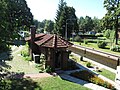
The state monument list as of December 31, 2012 lists an object in Kummersdorf among the architectural monuments in Storkow : Siedlung West 2, residential building . It is a Wilhelminian style building called "Villa Agnes". The villa is located on the Storkower Canal in the street Siedlung West 2, which turns off Kummersdorfer Hauptstrasse (Landesstrasse 40) shortly after the canal bridge. The place does not have a church . The train station and the lock are also noteworthy among the historical buildings.
Kummersdorf train station
On September 20, 1898, the first scheduled train ran on the new Königs Wusterhausen – Grunow railway via Beeskow to Grunow . The single-track branch line networked the Beeskow-Storkow district with the Berlin-Görlitzer railway and the Cottbus – Frankfurt (Oder) line . In 1907 a new train station was built in Kummersdorf. Later, a restaurant with a dance hall was added to the tall brick building . Badly damaged by the war in 1945, the station was rebuilt without a restaurant. The dance hall was now used as a bicycle storage room.
After German reunification , Deutsche Bahn wanted to demolish the station, and the extension with the former hall was actually demolished. The mayor of Kummersdorf prevented the main building from being removed. In the meantime, the almost unchanged building has been privatized and sold to Berlin artists by Deutsche Bahn. Today the NEB railcars stop in Kummersdorf if necessary (see above). The breakpoint and the adjacent former train station are north of the village on Bahnhofstrasse, which is part of the 6748 district road to Alt Stahnsdorf.
Kummersdorf lock
The Kummersdorf lock was built in 1862/65. It is located at kilometer 10.25 of the inland waterway class I Storkower Gewässer (SkG) and is the second lock of the Storkower Canal next to the Storkower lock ( lifting height 1.94 meters) . Their lifting height is 1.17 meters. The two heads are equipped with mortise gates . The filling of the chamber via contactors in the gates. The Kummersdorf suburb of the Berlin Waterways and Shipping Office is responsible for the lock . According to the information provided by the office, the data on the usable dimensions are slightly different data in brackets on the lock itself:
- Chamber length: 34.25 meters
- Chamber width: 5.31 meters (5.30 meters)
- Fall height: 1.17 meters (1.20 meters).
As with the renewed Storkower lock, these dimensions no longer correspond to the Finow dimension , which is 40.2 meters long. Since the canal and the lock were used by Finow barges after 1862/65, albeit not with a full load, it can be assumed that the chamber length was shortened later. It may have been shortened after the reconstruction, after the lock and the village bridge had been blown up in 1945 during the last days of the war. 1966 to 1967 the lock bridge was restored and the lock modernized. On the way to the capital region, the Kummersdorf lock passed 1009 barges and 84 rafts with grain, wood, peat and bricks per year on average in 1866 and 1867. Today the lock is only in operation in summer and is usually only used by passenger ships and up to 10,000 sports boats annually. The former towpath on the south side of the canal serves as a hiking and cycling path between Kummersdorf and Philadelphia. According to various descriptions of the place, the lock house is the oldest house in the village and is a listed building . However, it is not included in the official list of monuments of the Oder-Spree district as of 2012.

Railcar of the ODEG at the Kummersdorf demand stop

Privatized station building
from 1907
Kummersdorf lock in August 2007
Kummersdorf lock in August 2013
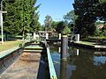
Kummersdorf lock in August 2013
_03.jpg)
_07.jpg)

_04.jpg)
_02.jpg)
Infrastructure and village life
In 2012, the Eberswalde University for Sustainable Development (HNEE) carried out a village survey in the core town of Storkow and in ten of the fourteen Storkow districts (all of the surrounding villages), including in Kummersdorf. Although the collected data […] are neither representative of the total population nor fully meet the standards of empirical social research , they nevertheless provide facts and information on the infrastructure and village life.
Villagescape
_12.jpg)
_05.jpg)
The image of the village is largely shaped by single-family houses . A small green village square is located on Kummersdorfer Hauptstraße on the east side of the canal. The fire station is located on the square and stands out from the other buildings with its red gates. In addition, an overview map of the Dahme-Heideseen area was set up here. Another small square with a memorial for the fallen of the First World War is at the eastern entrance to the town. The canal crosses Kummersdorfer Hauptstrasse and divides the village in half. If the old Kummersdorf is more on the east side, the west side is determined by the newer settlements west and east. Some individually designed signs and signposts that are made of wood and painted in bright colors fall out of the framework of the street signs that are common in Germany . These signs were completely renewed as part of the 575th anniversary when they were first mentioned in 2017.
Local self-government
The interests of Kummersdorf in the city of Storkow are represented by a mayor and a local council (deputy mayor). The Kummersdorfer - like the residents of most of the other districts - see the incorporation to Storkow in 2003 and the associated dependency rather critically and experience it as a reduction in their ability to act.
“It is seen as a 'setback' and many of the existing problems are attributed to it. Before we were a stable and debt-free community , emphasized a citizen in an interview. Therefore, a certain distance to the core town of Storkow can be felt, and the citizens have the feeling that everything is being dictated to them from above . The local advisory council criticized the lack of decision-making authority at village level and many also criticized the fact that everything had to be applied for in Storkow and that the financial resources for the interests of Kummersdorf were mostly lacking. "
Associations, community life
The club life is comparatively strong and is perceived by the residents as a particular strength of their village. These include: Voluntary Fire Brigade Association Kummersdorf, Volkssolidarität Bürgerhilfe Ortsgruppe Kummersdorf, Rural Women Association, Farmers Association Kummersdorf e. V., VKSK division “On the Upper Canal” e. V., VKSK division “Am Bahnhof” e. V. Kummersdorf, SV Handwerk Kummersdorf e. V. (bowling) and the Kummersdorf youth club. The highlights of the many festivals organized by the youth club and the fire brigade association are the Knutfest, the Easter fire , the carnival festivals or Zampern , summer festivals, fire brigade festivals and the Oktoberfest. Correspondingly, the neighborhood help and the good communicative exchange within the village community are generally described positively, even if deficits between the individual parts of the village are to be found in this area.
A partnership with the Rudniki district of Opalenica has existed since 2008. Opalenica is the twin town of Storkow (Mark) and is located in the Wielkopolski Voivodeship (Greater Poland). In the early years, this was more characterized by the exchange on the basis of senior citizens. This partnership has been intensified in other areas of society since 2014. The Rudniki fire brigade has a strong interest in working with the Kummersdorf fire brigade. In 2016, the first visits were started on the 70th anniversary of the Rudniki fire brigade. The return visit took place on the 85th anniversary of FF Kummersdorf in the same year. For the inauguration of the new fire station in Rudniki, specific requests for cooperation between the youth fire brigades of both fire brigades were expressed and the implementation was agreed on in a timely manner.
Local supply and economy
The local supply in Kummersdorf is relatively good compared to the other districts of Storkow (all villages), as there is at least one day care center and a mobile bakery. Nevertheless, most of the respondents rated the supply as poor, as there is no longer a single shop in the entire village and this becomes a problem, especially for older people, as soon as they are restricted in their mobility. Other businesses are a company for the installation of traffic control systems , a carpentry, two construction companies, two assembly companies, a painting company, two architects, a horse farm, an agricultural company, a kitchen construction company, a plumbing company, a hairdresser, an art and farrier's shop, a company for Blacksmithing and metal construction, a company for technical maintenance as well as the water and shipping authority Berlin with its branch in Kummersdorf. Despite the nature park location and the many pleasure boats on the canal, tourism no longer played a major role in Kummersdorf at the beginning of the 2010s. For most tourists, Kummersdorf is a transit point. The country inn Kleine Schänke , which is located directly at the lock with a boat mooring and beer garden, is used more often as a destination by boat tourists in particular. In the meantime, this restaurant is no longer available. It closed for good in 2016.
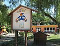
"Buratino" day care center

East settlement

West settlement

Kummersdorfer Hauptstraße with the village square and fire department

Bahnhofstrasse, part of the circuit road K 6748 by Alt Stahnsdorf
_07.jpg)
_09.jpg)
_10.jpg)
_03.jpg)
_14.jpg)
literature
-
HNE Eberswalde, University for Sustainable Development (FH) , Department of Landscape Use and Nature Conservation: Village survey in Storkow (Mark). Implemented by the Eberswalde University for Sustainable Development (FH) in cooperation with Brandenburg 21 e. V., June 18-22, 2012.
- Volume 1: Overarching analyzes: Storkow and its districts 10 years after the municipal reform. (PDF; 4.1 MB) As of September 30, 2012.
- Volume 2: District descriptions. (PDF; 15.2 MB) Status: September 2012. See Chapter 7: Kummersdorf . Pp. 66-75.
- Storkow (Mark). Insights into the history of an 800-year-old small town. Ed .: Mayor of the city of Storkow (Mark) in connection with the historical advisory board of the city. Complete production: Schlaubetal-Druck Kühl OHG, Müllrose 2009, ISBN 978-3-941085-72-5 . In this:
- Erich Oehring, Jürgen Pfeiler, Reinhold Zielke: Storkow and its districts in old and new views. Pp. 243-289.
- Klaus Rattemeyer: The Storkow waters - from raftsman canal to tourist magnet. Pp. 54-65.
- Gisela Show: From the Kummersdorf Chronicle. Pp. 216-220.
Web links
Individual evidence
- ^ Sophie Wauer: Brandenburgisches Namenbuch . Part 12 (= the place names of the Beeskow-Storkow district ), Franz Steiner Verlag, Stuttgart 2005, ISBN 3-515-08664-1 , pp. 226–228.
- ↑ a b c d page about Kummersdorf on the homepage of the city of Storkow (Mark) ( Memento of the original from May 14, 2013 in the Internet Archive ) Info: The archive link was inserted automatically and has not yet been checked. Please check the original and archive link according to the instructions and then remove this notice.
- ↑ Brigitte Nixdorf, Mike Hemm u. a .: Documentation of the condition and development of the most important lakes in Germany, part 5, Brandenburg , environmental research plan of the Federal Ministry for the Environment, Nature Conservation and Nuclear Safety , final report R&D project FKZ 299 24 274, on behalf of the Federal Environment Agency at the Chair of Water Protection at the Brandenburg Technical University Cottbus , 2004 Chapter 1.37 Wolziger See p. 155. PDF
- ↑ Brandenburg viewer, digital topographic maps 1: 10,000 (menu - "More data" - click and select accordingly; switch to the district boundaries "real estate cadastre" and there "districts".)
- ^ Minister for Agriculture, Environmental Protection and Regional Planning of the State of Brandenburg: Ordinance on the nature reserve “Storkower Canal” of May 24, 2004. (GVBl.II / 04, No. 13, p. 338). Potsdam, May 24, 2004.
- ↑ 3749-306 Storkower Canal. (FFH area) Profiles of the Natura 2000 areas. Published by the Federal Agency for Nature Conservation . Retrieved November 25, 2017.
- ↑ NEB, timetable RB 36 ( Memento of the original from May 1, 2015 in the Internet Archive ) Info: The archive link was inserted automatically and has not yet been checked. Please check the original and archive link according to the instructions and then remove this notice. (PDF)
- ↑ a b c History of the Storkower Canal on the website of the Berlin Water and Shipping Office
- ↑ a b Reinhard E. Fischer : The place names of the states of Brandenburg and Berlin , Volume 13 of the Brandenburg Historical Studies on behalf of the Brandenburg Historical Commission, be.bra Wissenschaft verlag, Berlin-Brandenburg 2005 ISBN 3-937233-30-X , ISSN 1860 -2436 . P. 98.
- ↑ Gisela Show: From the chronicle of Kummersdorf. S. 216. The source indicates: Sophie Wauer: Brandenburgisches Namenbuch . Part 12 (= the place names of the Beeskow-Storkow district ), Franz Steiner Verlag, Stuttgart 2005, ISBN 3-515-08664-1 , p. 80/81.
- ↑ Gisela Show: From the chronicle of Kummersdorf. P. 216f.
- ↑ Gisela Show: From the chronicle of Kummersdorf. P. 217ff.
- ↑ Gisela Show: From the chronicle of Kummersdorf. P. 218ff.
- ↑ StBA: Changes in the municipalities in Germany, see 2002
- ↑ Gisela Show: From the chronicle of Kummersdorf. P. 217f.
- ↑ Erich Oehring, Jürgen Pfeiler, Reinhold Zielke: Storkow and its districts…. P. 252
- ↑ a b Berlin Waterways and Shipping Office: Kummersdorf lock . As of December 14, 2012.
- ↑ Gisela Show: From the chronicle of Kummersdorf. P. 219f.
- ↑ Klaus Rattemeyer: The Storkow waters - from the raft canal to tourist magnet . P. 61.
- ↑ For example, on the description of the district on the Storkow website or in: HNE Eberswalde: Volume 2: Description of the district . 2012. p. 68.
- ↑ List of monuments of the state of Brandenburg: Landkreis Oder-Spree (PDF) Brandenburg State Office for Monument Preservation and State Archaeological Museum
- ↑ HNE Eberswalde: Village survey…. Volume 1: Comprehensive analyzes:…. 2012. p. 4.
- ↑ HNE Eberswalde: Village survey…. Volume 2: District descriptions. 2012. p. 68f.
- ↑ HNE Eberswalde: Village survey…. Volume 1: Comprehensive analyzes:…. 2012. p. 5; Volume 2: District descriptions. 2012. p. 72.
- ↑ HNE Eberswalde: Village survey… . Volume 2: District descriptions. 2012. pp. 66, 71f.
- ↑ HNE Eberswalde: Village survey…. Volume 2: District descriptions. 2012. p. 72.
- ↑ HNE Eberswalde: Village survey…. Volume 2: District descriptions. 2012. p. 74.
- ↑ Kleine Schänke restaurant. (No longer available online.) Archived from the original on January 16, 2016 ; Retrieved April 3, 2015 . Info: The archive link was inserted automatically and has not yet been checked. Please check the original and archive link according to the instructions and then remove this notice.
Alt Stahnsdorf | Bugk | Görsdorf near Storkow | Large oak wood | Looking Big | Kehrigk | Looking small | Kummersdorf | Limsdorf | Philadelphia | Rieplos | Schwerin | Selchow | Wochowsee