Hainberg (Göttingen Forest)
| Hainberg | ||
|---|---|---|
|
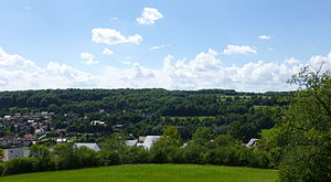
East view of the Hainberg |
||
| height | 314.7 m above sea level NN | |
| location | Lower Saxony , Germany | |
| Mountains | Göttingen Forest , Leinebergland | |
| Coordinates | 51 ° 32 '27 " N , 9 ° 58' 22" E | |
|
|
||
The Hainberg is 314.7 m above sea level. NN high elevation west of Herberhausen in the west of the Göttingen Forest in the district of Göttingen in southern Lower Saxony . In regional parlance, the entire western slope of the Göttingen Forest, which adjoins the central city of Göttingen to the east, is referred to as Hainberg , although parts of it also have their own names such as Mittelberg and other parts can be counted on the slopes of neighboring mountains.
geography
The Hainberg rises on the western roof of the Göttingen Forest, which represents a southern part of the Leinebergland . The mountain is located to the west of the development in the area of Herberhausen, a district of Göttingen . While the western slope of the Hainberg has been predominantly forested again since the end of the 19th century, the eastern slope that slopes down towards the Lutter valley is used as pasture and meadow. The northern branch of the mountain plateau is the Warteberg (289.4 m), the southern branch of the Mittelberg (303.4 m). A shallow depression separates the Mittelberg from the Kleperberg to the south .
Before the reforestation, grazing with animals was carried out on the Hainberg, especially where the soil was too poor to allow for more intensive arable farming. The names there such as “ Molkengrund ”, “ Trift ” or “ Schäferbrunnen ” refer to the historical use before reforestation in the second half of the 19th century. Until reforestation took place, the areas were used intensively as pasture for sheep , goats and pigs , because the sometimes quite steep areas offered no possibility for more profitable agricultural use. Only poor grass and thorn bushes grew on the so-called " Dreische ", the lean grassy areas on stony limestone soil, this was a result of intensive and continuous grazing than due to natural conditions.
Buildings

There is a transmitter on the eastern flank of the Hainberg . A water tank is located north of the Hainberg at the transition to the Warteberg. Where the Herberhäuser Stieg crosses the height of the Hainberg, the Osterholz bench was set up as a bench. The Wiechert earthquake observatory is located on the Hainberg. The lower (western) slope of the Hainberg was prepared after the start of reforestation based on the concept of landscape parks. The areas closer to the city (Schillerwiese, lower Molkengrund) were designed as a park and provided with various elements such as designed fountains, viewpoints, stone-lined paths, stairs and stone tables. The Reinsbrunnen stands on the whey ground, which feeds the swan pond in Cheltenhampark with its water. The neighboring Kleine Reinsbrunnen has a grotto-like border and a bronze sculpture in the form of a water woman . With further distance from the city, the park character of the Hainberg decreased. The Owl Tower is located on a western branch of the Mittelberg .
To the south of the Hainberg there are several wetlands designated as natural monuments.
Web links
Individual evidence
- ↑ Map services of the Federal Agency for Nature Conservation ( information )
- ↑ a b c City of Göttingen, city map - scale 1: 10,000 , processing status 1991–94 with supplements up to 10/95
- ↑ Bernd Herrmann Ulrike Kruse (ed.): Scenes and themes of environmental history ; Universitätsdrucke Göttingen Graduiertenkolleg 1024 Interdisciplinary Environmental History Natural Environment and Social Action in Central Europe (2010) p. 24

