Halmø
| Halmø | ||
|---|---|---|
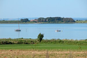
| View to Halmø Island | ||
| Waters | Baltic Sea | |
| Archipelago | Danish South Seas | |
| Geographical location | 54 ° 53 '18 " N , 10 ° 29' 42" E | |
|
|
||
| surface | 45.3 ha | |
| Residents | uninhabited | |
| Halmöhe on the map from 1665 | ||
Halmø is since the late 1970s uninhabited 45.3 hectares large Danish island in the " Danish South Sea the community" north Ommel on Ærø located. The island belongs to the parish community ( Danish : Sogn ) Marstal Sogn in the Harde terø Herred , which belonged to the Nordborg Office while Ærø was part of the Duchy of Schleswig , after Ærø was ceded to the Kingdom of Denmark with the Peace of Vienna of 1864 to the then Svendborg Office . With the abolition of the Harden structure with the Danish municipal reform in 1970 , the island became part of the Marstal municipality in what was then Fyns Amt , which became part of Ærø municipality on January 1, 2006 (one year before the municipal reform on January 1, 2007 ) , which had been in effect since 2007 belongs to the region Syddanmark .


