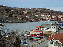
Hamburgsund
| Hamburgsund | ||||
|
||||
| State : | Sweden | |||
| Province (län): | Västra Götalands län | |||
| Historical Province (landskap): | Bohuslan | |||
| Municipality : | Tanum | |||
| Coordinates : | 58 ° 33 ' N , 11 ° 17' E | |||
| SCB code : | 4372 | |||
| Status: | Crime scene | |||
| Residents : | 706 (December 31, 2015) | |||
| Area : | 1.37 km² | |||
| Population density : | 515 inhabitants / km² | |||
| Hamburgsund (Hamburgö) | ||||
|---|---|---|---|---|
| Coordinates : | 58 ° 33 ' N , 11 ° 16' E | |||
| SCB code : | S4560 | |||
| Status: | Småort | |||
| Residents : | 133 (December 31, 2015) | |||
| Area : | 1.17 km² | |||
| Population density : | 114 inhabitants / km² | |||
| List of perpetrators in Västra Götaland County | ||||
Hamburgsund is a town in the Swedish municipality of Tanum in the historic Bohuslän province . It lies on both sides of the strait of the same name, which separates the island of Hamburgö from the Swedish mainland.
etymology
The place is named after the island, which was formerly known as Hornbora ("The Horn-Bearer"), which probably refers to smaller peninsulas on the west and south sides. There is no connection with the German city of Hamburg or the origin of its name.
history
Unconfirmed traditions tell of a Thing square near what is now Hamburgsund, where court meetings of the Viken region (Bohuslän and Norwegian areas around the Oslofjord ) were held. It is said to have been near a castle that no longer exists called Karlsborg or Hornborg.
The place itself was first mentioned as a customs post in 1585 . It developed mainly into the center of freight traffic in the region. The fishermen , on the other hand, mostly sold their catches in Sjöviken on the other side of the island. Hamburgsund only lost its important position in freight traffic in the middle of the 20th century with the development of larger ships and better land vehicles.
The previously contiguous crime scene on both sides of the strait was divided up by Statistiska centralbyrån in 2015 : The smaller part on the island of Hamburgö is now designated as Småort , which stretches across the island with the districts Berga, Hamnekärret, Husmarken, Lössgård, Norgård, Sjöviken and Södra Röd.
Economy and Infrastructure
A ferry connects the two parts of the village, where most of the local utilities are located. Since the place Sjöviken has now withered into a small settlement, the fishermen of the municipality Hamburgsund have chosen as their main port.
Culture
In memory of the suspected Thing Square one was near the former castle Viking village rebuilt (Hornbore by) . A Viking Festival takes place here every August.
The town's chapel was consecrated in 1915.
The Association of Local Folkets Hus has a rich annual program.
Individual evidence
- ↑ a b c d Statistiska centralbyrån : Land area per crime scene, folkmängd and invånare per square kilometer. Vart femte år 1960 - 2015 (database query)
- ↑ a b c d e Hamburgsund ( Memento of the original from September 27, 2007 in the Internet Archive ) Info: The archive link was inserted automatically and has not yet been checked. Please check the original and archive link according to the instructions and then remove this notice. (Schw.), Information from the Tanum community, accessed November 17, 2012.
- ↑ Hamburgsund Chapel , building register of the Reichsantiquaramt (RAÄ)
Web links
- Hamburgsund.com , local website (Swedish)
- Hornbore by , Viking Village
- Hornbore ting , Viking Festival

