
Main square (Rapperswil)
_-_Zytturm_-_Rathaus_2013-04-01_15-09-15_ShiftN.jpg)

.JPG)

The main square is a public square in the old town of Rapperswil, a district of the Swiss municipality of Rapperswil-Jona in the canton of St. Gallen .
Location and geography
The main square is located in the heart of the old town of Rapperswil , north of the Fischmarktplatz , and is connected to it by the Fischmarktstrasse. The largest inner-city square in Rapperswil-Jona has a rectangular design and all inner-city streets start from it: Hintergasse , Marktgasse and Seestrasse (in the west), Kluggasse, Eiergasse, Webergasse and Rathausstrasse (in the east).
history
.JPG)
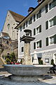
Up until the beginning of the 14th century, the eastern city wall led from north to south over the entire length of today's main square, which sloped slightly towards the lakeshore, to the lakeside fortification at the fish market square. The main square, as the largest public space within the walled city, was created with the eastern expansion of the city (Webergasse and Kluggasse). It received its central function when the citizens of Rapperswil built the first fountain not far from the castle and parish church. The fountain was fed by wooden " Tüchel " ( Teuchel ), which led the water over four kilometers from Tägernau near Jona into the old town.
In the late Middle Ages, the water of the Stadtbach from the “ Gaisrain ” in Jona was diverted from the river of the same name by means of a weir and directed from Engelplatz to the old town, flowed through Hals- and Schmiedgasse and flowed into upper Lake Zurich at today's Fischmarktplatz . The town hall on the main square was first mentioned in 1419. After the invasion of the French revolutionary troops under General Nouvion, a tree of freedom was erected on the main square on May 1, 1798 and France was welcomed as liberator.
With the demolition of the city wall, the Rickenstrasse (Neue Jonastrasse) built by the canton of St. Gallen was led straight into the city center from 1829 - the connection to the main square was only possible under police protection against the angry landowners. Until then, the only land connection to Rapperswil led from Engelplatz over the Halstor to and from the wooden bridge over the Obersee to the second city gate at what was then the “ inner harbor ” (fish market square) or Heilig Hüsli .
In 1836 the chapel on the so-called church staircase was removed and a pillar terrace with the so-called castle staircase to the Herrenberg was built in its place by 1894, giving the front of the square towards the Herrenberg largely its present appearance. The two-flight flight of stairs was made from Ticino granite and reddish nails from the Goldau rockslide .
Sights and events
The north-eastern axis of the Fischmarktplatz has been shaped by the redesigned access to the Herrenberg since 1894, dominated by the castle , the parish church and the Liebfrauenkapelle . The southeast end is bounded by the town hall , framed by town houses, shops and cafés in buildings from the early modern construction phase of Rapperswil, including the houses of the Gaudy, Göldlin, Rotenflue, Rickenmann and Fornaro families. The library and archive of the Poland Museum have been located in the " Burghof " since 1987 .

View from the castle stairs
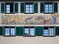
Founding legend of the city of Rapperswil near the castle courtyard
Fountain on the main square, in the background the bell tower of the parish church

Castle stairs from 1893/94


_2013-04-01_14-47-09.JPG)

A large part of the numerous cultural events in Rapperswil take place on the main square and the adjacent fish market, including the Christmas market and the Eis-Zwei-Geissebei .
See also sights in the old town
Fountain in the main square
_-_Hauptplatz_-_Schlosstreppe_2012-02-21_16-21-54.JPG)
" The nüwen stony fountain at the top of the brot Louben " was built by the Rapperswil council at the end of the 16th century. After 1606, a nobleman from Alsace financed a water pipe made of pine wood for the Capuchin monastery to draw its water from the " square fountain ". A contemporary illustration shows a Renaissance fountain with a hexagonal basin and a baluster-shaped fountain column. The stone sculpture of an ensign (" Platzbrunnenmann ") was redesigned in 1727. In 1734 the stonemasons Bernhard Helbling and son renewed the fountain column and were granted citizenship for their work. In 1835/36 the existing fountain was replaced by the late classicist system that still exists today. The advertising leaflet for the “Freihof” restaurant from 1841 shows the fountain in this form. The round and ribbed goblet trough with lip rim is made up of two limestone bowl halves made from Solothurn Jura limestone . The fluted fountain column with a lotus capital stands above a pedestal decorated with rosettes, has a fountain shaft with two spouts and carries a crowning vase above the cover plate, which takes up the shape of the basin again. Until 1897, steps arranged in a circle led to the fountain, which were removed after the church ascent was redesigned.
traffic
The square is part of the pedestrian zone in the city center and is close to the train station with access to the Zurich S-Bahn and the bus network of the Zürichsee and Oberland transport companies as well as the scheduled boats of the Zürichsee-Schiffahrtsgesellschaft on the Zürichsee and the Hensa on the Obersee. The extension of the Neue Jonastrasse, the Rathausstrasse, is restricted to use. The underground car park at the neighboring Fischmarktplatz is accessible from the tourist office building.
literature
- Peter Röllin: Rapperswil-Jona cultural building set: 36 museums without a roof . Rapperswil-Jona 2005, ISBN 3-033-00478-4 .
Web links
Individual evidence
- ↑ a b c d e website of the Rapperswil-Jona water supply: History of the old Rapperswil fountains ( memento of the original from October 29, 2013 in the Internet Archive ) Info: The archive link was inserted automatically and has not yet been checked. Please check the original and archive link according to the instructions and then remove this notice. , accessed April 11, 2013.
- ↑ In the Rapperswil-Jona City Museum , the remains of such water pipes are exhibited together with the corresponding Teuchel auger.
- ^ Website of the city of Rapperswil-Jona: Culture , accessed on April 11, 2013.
- ^ Website of the city of Rapperswil-Jona: Events ( Memento of the original from June 16, 2013 in the Internet Archive ) Info: The archive link has been inserted automatically and has not yet been checked. Please check the original and archive link according to the instructions and then remove this notice. , accessed April 11, 2013.
- ^ Minutes of the Council B 31, January 25, 1727, Rapperswil City Archives
- ^ Website of the city of Rapperswil-Jona: Verkehr , accessed on April 11, 2013.
Coordinates: 47 ° 13 '36.1 " N , 8 ° 48' 59" E ; CH1903: 704340 / 231555