
Henning (Tennessee)
| Henning | |
|---|---|
 |
|
| Location of Henning in County and Tennessee | |
 |
|
| Basic data | |
| Foundation : | 1873 |
| State : | United States |
| State : | Tennessee |
| County : | Lauderdale County |
| Coordinates : | 35 ° 40 ′ N , 89 ° 34 ′ W |
| Time zone : | Central ( UTC − 6 / −5 ) |
| Residents : | 945 (as of 2010) |
| Population density : | 277.9 inhabitants per km 2 |
| Area : | 3.4 km 2 (approx. 1 mi 2 ) of which 3.4 km 2 (approx. 1 mi 2 ) are land |
| Height : | 89 m |
| Postal code : | 38041 |
| Area code : | +1 731 |
| FIPS : | 47-33360 |
| GNIS ID : | 2405818 |
Henning is a town in Lauderdale County in the western US state of Tennessee . According to the United States Census 2010 , the population was 945.
history
Henning was founded in 1873 as a result of the construction of a railway station and was officially recognized two years later. Today Henning is mainly inhabited by African Americans who settled there as a result of slavery and associated work in the area of Lauderdale County.
Population development
| year | 1880 | 1890 | 1910 | 1920 | 1930 | 1940 | 1950 | 1960 | 1970 | 1980 | 1990 | 2000 | 2010 |
| Residents | 148 | 420 | 582 | 495 | 639 | 415 | 493 | 466 | 605 | 638 | 802 | 970 | 945 |
| Source: United States Census | |||||||||||||
Attractions
- Alex Haley House and Museum State Historic Site : House where the writer and Pulitzer Prize winner Alex Haley spent part of his childhood, now a museum dedicated to him ; as "WE Palmer House" in the National Register of Historic Places added
- Fort Pillow State Park : State Park , which is largely in the Hennings area; symbolizes the location of the battle for Fort Pillow in the Civil War , in which a Confederate force under Nathan Bedford Forrest defeated a far inferior army of the northern states on April 12, 1864 and then committed a massacre of prisoners.

The WE Palmer House (2007)

Plaque in front of the WE Palmer House

Alex Haley's grave
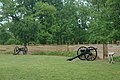
Cannons at Fort Pillow (2006)


Web links
Commons : Henning (Tennessee) - Collection of pictures, videos and audio files
- General information, diagrams and photos on city-data.com (English)
- Website of Alex Haley House and Museum State Historic Site (English)