
Heubatspitze
| Heubatspitze | ||
|---|---|---|
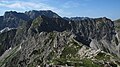
 Heubatspitze from the west |
||
| height | 2008 m above sea level NHN | |
| location | Bavaria , Germany | |
| Mountains | Thumb group , Allgäu Alps | |
| Dominance | 0.8 km → Rotspitze | |
| Notch height | 58 m ↓ notch to the Rotspitze | |
| Coordinates | 47 ° 27 '32 " N , 10 ° 22' 52" E | |
|
||
| particularities | Part of the northern Hindelanger via ferrata | |

The Heubatspitze (also Gemsbollenkopf or Heubatkopf ) is a 2008 m high German mountain peak in the Allgäu Alps .
Location and surroundings
The summit, located in the subgroup thumb group , rises in the ridge that stretches from the Breitenberg ( 1893 m ) in the north over the Hohe Gänge ( 1946 m ) and the Heubatspitze itself to the Kleiner Thumb ( 2197 m ) in the south. The Haseneckscharte ( 1895 m ) is located between the Heubatspitze and the Little Thumb . To the west, a ridge with little incisions ( 1950 m ) runs to the Rotspitze ( 2034 m ). To the east a ridge runs down into the Hintersteiner valley.
Origin of name
An Elb Spiz was first mentioned in 1774 by Peter Anich's Atlas Tyrolensis . The name given to this was probably the Alpe Elpen, whose pasture area lies northeast below the mountain. The current name is derived from the hay fields in the southern flank, which are locally called Hoibaten .
Ascent
The normal route to the Heubatspitze runs as a hiking trail in partly steep terrain from the Retterschwanger Valley over the Haseneckalpen to the Haseneckattel and from there over the southern ridge to the summit. In addition, the transition from the Rotspitze is not difficult. Two variants are possible as part of the northern part of the Hindelang via ferrata . From Breiteberg a partial wire leads secured climbing plant with iron ladder of the Hohe courses to Heubatspitze, these are surefootedness , head for heights and climbing assets I. Difficulty necessary. The descent from the Little Thumb to the Haseneck Saddle has the same requirements.
photos
From the high corridors

Southern flank with Rotspitze

Summit cross

Iron ladder on the north-facing summit structure


Web links
Individual evidence
- ↑ Compass hiking, bike and ski tour map: Sheet 03 Oberstdorf, Kleinwalsertal (1: 25,000). ISBN 978-3-8549-1231-6 (status: 2009).
- ↑ Dieter Seibert: Alpine Club Guide alpine - Allgäu Alps and Ammergau Alps . 17th edition. Bergverlag Rother, Munich 2008, ISBN 978-3-7633-1126-2 , p. 118.
- ↑ a b Dieter Seibert: Alpine Club Guide alpine - Allgäu Alps and Ammergau Alps . 17th edition. Bergverlag Rother, Munich 2008, ISBN 978-3-7633-1126-2 , p. 288 f.
- ↑ Bavarian Surveying Administration : BayernAtlas . Retrieved February 28, 2013.
- ^ Thaddäus Steiner : Allgäu mountain names . 2nd Edition. Kunstverlag Josef Fink, Lindenberg 2008, ISBN 978-3-89870-389-5 , p. 80 f.