Hinterer Maurerkeeskopf
| Hinterer Maurerkeeskopf | ||
|---|---|---|
|
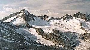
Hinterer Maurerkeeskopf (far right) with Large Geiger, Geigerkopf and Small Maurerkeeskopf (from left to right) |
||
| height | 3311 m above sea level A. | |
| location | East Tyrol / Salzburg , Austria | |
| Mountains | Venediger group | |
| Coordinates | 47 ° 5 '34 " N , 12 ° 17' 1" E | |
|
|
||
| First ascent | L. Purtscheller with J. Grill sen. (1881) | |
| Normal way | From the Essen-Rostocker Hütte via the southern flank ( II ) | |
The Hintere Maurerkeeskopf ( 3311 m above sea level ) is a mountain peak of the Tauern main ridge in the Venediger group on the state border between Tyrol ( Lienz district ) and Salzburg ( Zell am See district ) or on the municipal border between Prägraten am Großvenediger and Neukirchen am Großvenediger . The mountain was originally called Heiligengeistkeeskopf and got its current name from Franz Keil . For the first time the Hinterer Maurerkeeskopf from Ludwig Purtscheller with J. Grill sen. climbed on July 20, 1881 over the east ridge.
location
The Hintere Maurerkeeskopf lies between the northeast summit of the Middle Maurerkeeskopf ( 3283 m above sea level ) in the southeast, the Hahenkamm ( 3212 m above sea level ) in the northwest and the Kleiner Maurerkeeskopf in the east, from which the Hintere Maurerkeeskopf passes through the Maurertörl ( 3104 m above sea level ) is separated. The long northwest ridge of the Hinteren Maurerkeeskopf stretches over the Hahenkamm and Gamsspitzsattel to the Gamsspitz ( 2888 m above sea level ), the southwest ridge to the middle or Vorderen Maurerkeeskopf is known as the Maurerkeeskopfgrat. South of the Hinteren Maurerkeeskopf is the Maurerkees, from which the Maurerbach rises, to the north are the Krimmlertörlkees and Obersulzbachkees .
Promotion opportunities
The normal route to the Hinteren Maurerkeeskopf leads from the Essener-Rostocker Hütte first on the marked path along the Maurerbach in the direction of the Maurertörl. The further ascent leads to the left past the Maurerkee glacier tongue to the southeast spur and then over the glaciated southern flank ( II ). Another possibility of ascent is from the Essener-Rostocker Hütte over the Südostsporn, from Maurertörl over the east ridge or from the north over the northwest ridge from the Gamsspitzsattel.
Individual evidence
- ↑ according to AMAP
literature
- Georg Zlöbl: The three thousand meter peaks of East Tyrol in the Hohe Tauern National Park . Verlag Grafik Zloebl, Lienz-Tristach 2007. ISBN 3-200-00428-2 .
- Willi End : Alpine Club Leader Venediger Group . Bergverlag Rudolf Rother ; 5th edition 2006, ISBN 3-7633-1242-0 .
- Alpine Club Map 1: 25,000, sheet 36, Venediger Group , ISBN 3-928777-49-1 .

