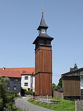
Rear rod
|
Rear rod
City of ice field
Coordinates: 50 ° 28 ′ 16 ″ N , 10 ° 54 ′ 42 ″ E
|
|
|---|---|
| Height : | 700 m above sea level NN |
| Residents : | 175 |
| Incorporation : | April 23, 1969 |
| Incorporated into: | Weapon rod |
| Postal code : | 98673 |
| Area code : | 03686 |
Hinterrod and Waffenrod form the common district of Waffenrod / Hinterrod in the town of Eisfeld in the Hildburghausen district in Thuringia .
location
The two places are close together in the Thuringian Forest Nature Park on Landesstraße 2053 Eisfeld- Masserberg, surrounded by meadows and forest and wet biotope spring hollows and dry grassland locations, i.e. on a high plateau of the Thuringian ridge at about 700 meters above sea level.
history
Hinterrod was first mentioned in a document from 1330-1340. With Masserberg, Waffenrod and Hinterrod are important points for tourism and sport. 525 residents live in both settlements. Tourism and crafts create jobs. In 1927 the community built a church. An organ builder from Stadtilm renovated the organ.
Web links
Commons : Hinterrod - collection of images, videos and audio files
Individual evidence
- ^ Wolfgang Kahl : First mention of Thuringian towns and villages. A manual. Rockstuhl Verlag, Bad Langensalza, 2010, ISBN 978-3-86777-202-0 , p. 124
- ↑ Hinterrod on the website of the municipality.Retrieved on April 12, 2012
