
Hochkünzelspitze
| Hochkünzelspitze | ||
|---|---|---|
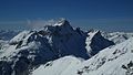
 Hochkünzelspitze seen from the south |
||
| height | 2397 m above sea level A. | |
| location | Vorarlberg , Austria | |
| Mountains | Lechquellen Mountains | |
| Dominance | 4.4 km → Zitterklapfen | |
| Notch height | 352 m ↓ Ruchwannejöchle | |
| Coordinates | 47 ° 16 '18 " N , 10 ° 1' 49" E | |
|
||
| Type | Rock peaks | |
| rock | Main dolomite | |
| Normal way | Biberacher Hut - south flank | |

The Hochkünzelspitze is 2397 m above sea level. A. high mountain in the Lechquellen Mountains in the Austrian state of Vorarlberg .
Location and surroundings
The Hochkünzelspitze with its side ridges forms the eastern end of the Zitterklapfen group . In the south of the mountain lies the Schadona Pass ( 1840 m ), which forms the transition to the Rothorn ( 2239 m ). To the west, the Zitterklapfenkamm runs across Glattjöchl ( 2180 m ) and Schönegg ( 2260 m ) to Schöneberg ( 2282 m ). In the north, the Künzeljoch separates the Hoch- from the Niedere Künzelspitze ( 2156 m ). To the northeast and east, the flanks of the Hochkünzelspitze fall into the valley of the Bregenz Ach . The east ridge of the Hochkünzelspitze bears the insignificant elevation of the Wasserkluppe. The equally insignificant jagged rock of the Giglturm ( 2112 m ) rises up from the south side .
The Hochkünzelspitze is located in the municipality of Schoppernau .
In the west-southwest direction there is no mountain beyond the Rhine Valley that is higher than the Hochkünzelspitze, so that you can see the Eiger / Mönch / Jungfrau triad about 170 km away , as well as other well-known peaks of the Bernese Alps with good visibility.
Biotopes

There are three biotopes worthy of protection on the Hochkünzelspitze .
The first is located on the south side of the Giglturm and is formed from brown sedges - moors ( Caricetum nigrae ), which consist of a layer of peat about one meter thick on limestone . Endangered species in this biotope are spotted orchid ( Dactylorhiza maculata ), yellow gentian ( Gentiana lutea ) and brook avens ( Geum rivale ).
The second group of biotopes consists of four oligotrophic lakes, which are located on the Glattjöchl and in the cirque between Hochkünzelspitze and Schöneberg and whose edges are formed by Scheuchzer's cotton grass ( Eriophorum scheuchzeri ). The highest lake at about 2200 meters at Glattjöchl has Bryum pseudotriquetrum and a limestone spring corridor ( Cratoneuretum falcati ). At around 2100 meters above sea level under the Schöneberg you can find blue grass eyrie grass ( Seslerio-Semperviretum ) and round-leaved hellerkraut ( Thlaspi rotundifolia ), in the water iron-oxidizing microorganisms sometimes cause a reddish color. The last two lakes in the Upper Gautalpe area, which are covered with snow for most of the year, are at an altitude of around 1900 meters.
To the northwest, between Hoher and Niederer Künzel, lies the biotope of the areas around the Obere Gautalpe, which is extensively used for agriculture. The surfaces are fed by numerous springs and the subsurface consists mainly of limestone and dolomites. Notable plants are ranunculus aconitifolius ( Ranunculus aconitifolius ), mountain trisetum flavescens ( Anthrisco-Trisetetum ), rust Seggehalden ( Caricetum ferrugineae ), blue grass heaps and lean Bergheumähder ( Hypochoero-Nardetum ). In endangered species in this area are Allermannsharnisch ( Allium victorialis ) and pink spherical orchids ( Traunsteinera globosa ).
Ascent
The base for the ascent of the Hochkünzelspitze is the Biberacher Hut ( 1846 m ) on the Schadona Pass to the south. The path leads past the Giglturm on the south side to the steep summit structure. You reach the pre-summit through steep grass and a place with wire rope insurance, from which you walk over a very short, narrow ridge to the wire rope insured, rugged main summit. Surefootedness and a head for heights are required for the ascent . The Hochkünzelspitze can also be reached from the valley of the Bregenz Ach. Via the Schalzbach pass and the Gautalpen, the path leads up to the Glattjöchl and from there to the normal route . For the north ridge, difficulty level II must be mastered in the brittle rock.

In winter, both routes can also be used as a ski tour . The ski depot is then created about 50 meters in altitude to the west and below the main summit.
Summit cross
The summit cross on the Hochkünzelspitze bears the inscription: “ CHRIST YESTERDAY TODAY AND IN ETERNITY. "
photos

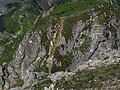
North flank
East Side

Summit cross
Transition pre-summit - main summit


Web links
Individual evidence
- ↑ Dieter Seibert : Bregenzerwald and Lechquellen Mountains. Alpine Club Guide alpine. 1st edition. Bergverlag Rother, Munich 2008, ISBN 978-3-7633-1095-1 , p. 150 .
- ↑ Dieter Seibert : Bregenzerwald and Lechquellen Mountains. Alpine Club Guide alpine. 1st edition. Bergverlag Rother, Munich 2008, ISBN 978-3-7633-1095-1 , p. 22nd f .
- ^ Federal Office for Metrology and Surveying Austria: Austrian Map online (Austrian map 1: 50,000) . Retrieved April 23, 2012.
- ↑ Measurement function on the digital Swiss national map www.geoadmin.ch
- ^ Markus Staudinger: Biotope inventory of the community of Schoppernau. (PDF; 2.6 MB) Update of the Vorarlberg biotope inventory. 2009, pp. 45–49 , accessed April 23, 2012 .
- ↑ Dieter Seibert : Bregenzerwald and Lechquellen Mountains. Alpine Club Guide alpine. 1st edition. Bergverlag Rother, Munich 2008, ISBN 978-3-7633-1095-1 , p. 154 ff .
- ↑ Anton Kempf, Rainer Kempf: Bregenzerwald ski tour guide including the Great Walsertal and Lechquellen Mountains . 2nd Edition. Panico Alpinverlag, Köngen 2006, ISBN 978-3-936740-12-7 (p. 104 ff.).