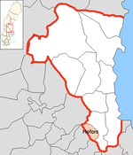
Hofors (municipality)
| Hofors parish | |||||
|---|---|---|---|---|---|
|
|||||
| State : | Sweden | ||||
| Province (län): | Gävleborg County | ||||
| Historical Province (landskap): | Gästrikland | ||||
| Main place: | Hofors | ||||
| SCB code: | 2104 | ||||
| Residents : | 9588 (December 31, 2019) | ||||
| Area : | 445.7 km² (January 1, 2016) | ||||
| Population density : | 21.5 inhabitants / km² | ||||
| Website : | www.hofors.se | ||||
| List of municipalities in Sweden | |||||
Coordinates: 60 ° 33 ' N , 16 ° 17' O Hofors is a municipality ( Swedish kommun ) in the Swedish province Gävleborg and the historical province Gastrikland . The main town of the municipality is Hofors .
By the municipality leading European route E16 and the national highway 68 and the railway lines Gavle - Falun ( Bergslagernas Järnvägar ) and Krylbo - Storvik .
history
The municipality of Hofors has existed since 1925.
geography
The municipality is located in the Bergslagen region on the border with Dalarna . It is largely taken up by a wooded hilly landscape, only the area along the Storån river is flat and open.
There are iron ore deposits in the community that were mined from the Middle Ages to the beginning of the 20th century.
economy
In connection with the ore mining , which is now closed , an iron and steel processing industry emerged, which still dominates the economic life of the community today. The largest employer is Ovako Steel AB .
places
The following places are localities ( tatorter ):
Twin cities
The municipality Hofors has two sister cities :
-
 Fladså , Denmark
 -
 Kontiolahti , Finland
Web links
- Official website (English, Swedish)
Individual evidence
- ↑ Folkmängd i riket, län och kommuner December 31, 2019 at Statistiska centralbyrån
- ↑ Kommunarealer January 1, 2016 at Statistiska centralbyrån (including all inland waters)

