
Hohberge
The Hohberge are an inland dune in the forest areas of Mörfelden and Egelsbach in southern Hesse .
Geography and description
With a length of 3.7 km and an average width of about 100 meters, the Hohberge belong to the genus of the longitudinal dunes and run in a west-east direction. The Hohberge begin in the "Staatsforst Mörfelden" on the southeast edge of Mörfelden and end in the southwest of the Egelsbach district . The district boundary of Erzhausen follows its southern edge in the eastern part of the dune.
The highest point of the dune at 119 meters above sea level is, according to the information on the topographic map, about 500 meters from the eastern end on the leeward side ( 49 ° 58 ' N , 8 ° 37' E ) in the Egelsbach district. The eastern part of the Hohberge is called "Heegberg" (also: "Hegberg" and "Hege-Berg").
The Hegbach accompanies the northern edge of the dune at a short distance. To the south of the Hohberge, the stream of Erzhausen flows far away . The federal highway 5 crosses the dune area approximately in the middle.
geology
The sand dune was formed in the cold tundra climate by sand drifts from Pleistocene drifting sand at the end of the Vistula Ice Age. The west-east orientation resulted from the prevailing wind direction . The drifting sand dunes are part of an approx. 130 km long dune train that extends from Rastatt to Mainz .
flora
The Hohberge can be divided into different vegetation units:
- Mixed pine forest
- Pfriemengras - steppe lawn
- loose silver grass - dry grass
- Dry xerothermal awl grass lawn
Toponyms
Heegbach
- Erzhausen: The Heegbach
- Mörfelden: At the new Heegbach
Hedges and hedges
- Erzhausen: The Heegberg
- 1331 on the Heckin
- 1532 on the heck mountains
- 1541 zyhen the hege add
- 1552 The first hege field
- 1575 hoegberge
- today Heegberg
Picture gallery

Heegberghalle (2008)

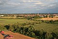
View from Heegberg to the south (2009)
View from Heegberg to the southeast (2009)


Others
On the southeast edge of the Hohberge is the "Heegberghalle", a barbecue area , a riding arena and a forest kindergarten ("Heegbachwichtel").
Individual evidence
- ^ Darmstadt and surroundings, Falkplan, Falk Verlag, Ostfildern, ISBN 978-3-8279-2260-1 .
- ^ Hans Ramge et al .: Südhessisches Flurnamenbuch , Hessische Historische Kommission Darmstadt, 2002, ISBN 3-88443-045-9 , pp. 467-471.
Coordinates: 49 ° 57 '53.7 " N , 8 ° 36' 35.1" E