
High Mechtin
| High Mechtin | ||
|---|---|---|
 Location of the Hohe Mechtin in the Drawehn ; Representation u. a. with light green (areas under 20 m), orange-red (50-75 m), dark brown (over 100 m) |
||
| height | 142 m above sea level NHN | |
| location | near Zernien , Lüchow-Dannenberg district , Lower Saxony ( Germany ) | |
| Mountains | Drawehn | |
| Coordinates | 53 ° 2 '39 " N , 10 ° 54' 34" E | |
|
||
| Type | Terminal moraine | |
| rock | Debris , sand , gravel | |
| Age of the rock | Saale ice age | |
| particularities | - highest elevation of Drawehn - observation tower |
|


The Hohe Mechtin near Zernien in the Lower Saxony district of Lüchow-Dannenberg forms with a height of 142 m above sea level. NHN is the highest elevation in Wendland and is also a striking elevation for the entire North German lowlands . It is about 2 km east of Gülden and is roughly the center of the Drawehn mountain range, which is also known as the East Hanoverian gravel or terminal moraine. In terms of nature , the area belongs to the Lüneburg Heath as a unit of Ostheide .
Geology and landscape
Debris made of sand, loam, gravel, boulders and meter-sized boulders , which the glaciers, coming from Scandinavia, had transported during several advances in the Saale Ice Age , remained after the melting in the form of the terminal moraine of Drawehn. Today the area is predominantly overgrown with pine forest, but especially in some apex and hillside locations, mixed deciduous forests, including oak, birch and beech, dominate the landscape.
Observation tower
The Hohe Mechtin is accessible from various villages in the area with hiking trails. On the summit plateau surrounded by forest, there is a half-open refuge for hikers and a 30-meter-high observation tower that can be climbed by the public and offers a panoramic view. The current structure made of larch and Douglas fir was built in 2015 and inaugurated on July 14th, initiated by the Elbhöhen-Wendland Nature Park .
Between 1971 and 2013 there was a previous building in the same place, which was around 22 meters high. After it was closed due to dilapidation in 2011, the old tower was blown up in March 2013.
photos

The High Mechtin with observation tower of Fließau seen

Boulder block in the forest on a steep slope
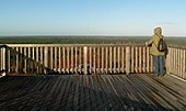
View from the tower to the north to the Dannenberg / Zernien transmitter
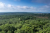
View from the tower to the south

Former observation tower on the Hoher Mechtin (2011)

New observation tower on the Hoher Mechtin (2015)


Individual evidence
- ↑ topographic map with the Hoher Mechtin ( memento of the original from April 2, 2015 in the Internet Archive ) Info: The archive link was inserted automatically and has not yet been checked. Please check the original and archive link according to the instructions and then remove this notice. (DTK 25; for mountain height see large enlargement of the map), on natur-erleben.niedersachsen.de
- ↑ Again over the treetops (p. 1) and panoramic view at a height of 172 meters (p. 3) , Elbe-Jeetzel-Zeitung, April 14, 2015; also: on ejz.de
- ↑ Inauguration ceremony: New observation tower on the Hohe Mechtin , July 14, 2015
- ↑ An end with a big bang ( Memento of the original from March 4, 2016 in the Internet Archive ) Info: The archive link was inserted automatically and has not yet been checked. Please check the original and archive link according to the instructions and then remove this notice. , Elbe-Jeetzel-Zeitung, March 18, 2013, p. 3, on ejz.de