
Holstenstrasse (Kiel)
| Holstenstrasse | |
|---|---|
|
|
|
 |
|
| At the southern end of Holstenstrasse, a pedestrian bridge leads to the Holstentörn shopping center and the Sophienhof behind it . | |
| Basic data | |
| place | Kiel |
| District | Old town |
| Created | 13th century |
| Newly designed | after 1945 (reconstruction), 1953–1957 (conversion into a pedestrian zone ) |
| Connecting roads | Schlossstrasse |
| Cross streets | Faulstrasse, Holstenbrücke / Berliner Platz, Hafenstrasse, Schrevenbrücke / Europaplatz, Ziegelteich |
| Places | Alter Markt , Asmus-Bremer-Platz, Holstenplatz |
| use | |
| User groups | Foot traffic |
The Holstenstrasse in the state capital Kiel has had her name since 1525 and was originally a land route into central Holstein . It begins at the Alter Markt , the center of the old town, which is planned to be laid out on a peninsula, and ends today at the main intersection at Ziegelteich.
Holstenstrasse is one of the oldest streets in Kiel. Together with the Dänische Straße , which branches off to the north of the Alter Markt , it forms the original north-south connection to and from Kiel. As such, it was already one of the traditional main shopping streets, but its importance for transport increased with the expansion of the highways in the 1840s. This was intensified by the steady growth of the city after the transition from the Duchy of Holstein to the Kingdom of Prussia in 1867. During the imperial era, most of the historic gabled houses on Holstenstrasse were replaced by new buildings typical of the period. In 1907 Holstenstrasse, which had ended in the suburbs , was extended to the south by demolishing the Schweffelhaus . Until then, the main traffic to the south had to be led through the narrow street Klinke, which had connected Holstenstrasse with the road to the south mentioned in the next section Sophienblatt.
During the Second World War, the development on Holstenstrasse was destroyed with a few exceptions - namely new buildings from the 1920s in the new southern part on the west side of what is now Holstenplatz. A modern reconstruction was carried out, whereby the Berliner Platz was created as a new traffic junction between the old town and suburb, while the southern part including the completely destroyed latch was redesigned into the spacious Holstenplatz. In the east, this borders directly on the new main road, named after the first post-war mayor of Kiel, Andreas Gayk .
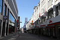
Kieler Holstenstraße is the first street in Germany that has been closed to private traffic and has been converted into a pedestrian zone . In contrast , the stairway in Kassel , which was built almost at the same time, is the first new planning and realization of a pedestrian zone in Germany.
Against the resistance of the retail trade, the upper part of Holstenstrasse was closed to private traffic on December 12, 1953. In 1957, the lower (southern) part of the Holstenstrasse became "within walking distance", as it was called in official German at the time.
In Kiel, Holstenstrasse is the traditional shopping mile , the southern end of which can be reached on dry feet through a covered pedestrian bridge and the Sophienhof -Holstentörn shopping mall from the main station. Department stores and specialty stores of all kinds are located here .
In contrast to other large cities, this pedestrian zone is relatively quiet after the shops have closed because there are not many restaurants there that would distinguish Holstenstrasse from the rest of the inner city area. The only exception is the Kieler Woche , when Holstenstrasse is transformed into the venue for a huge folk festival , and to a lesser extent the Advent season, when there is a Christmas market on the neighboring Holstenplatz where people meet for traditional punch .
At the northern end of Holstenstrasse is the Old Market with the Nikolaikirche , which forms the center of the historic town center. Further south, on Asmus-Bremer -Platz, which is part of Holstenstrasse, is the newspaper building of the Kieler Nachrichten . If you turn east from Asmus-Bremer-Platz , you can take Hafenstraße directly to the Kiel Fjord to the Schwedenkai , where the car ferries to Sweden arrive and depart.
On Europaplatz , west of Holstenstrasse, is the Sparkassen-Arena , where, for example, the Bundesliga games of the multiple German handball champions THW Kiel take place.
In the meantime, shop rents are rising and chains such as Intersport Knudsen and H&M have given up their shops on Holstenstrasse. These shops have been empty since then.
photos
The northern Holstenstrasse

The building of the Kieler Nachrichten on Asmus-Bremer-Platz

Asmus-Bremer-Plastik on the square of the same name


swell
- IHK zu Kiel, magazine for economy and politics 1/75; City Archives Kiel; Building Administration Office of the City of Kiel; Administrative reports of the city of Kiel (1953 ff.)
- Jürgen Jensen: Historical Cityscape Atlas Kiel. Neumünster 1992.
Web links
- Hans-G. Hilscher, Dietrich Bleihöfer: Holstenstrasse. In: Kiel Street Lexicon. Continued since 2005 by the Office for Building Regulations, Surveying and Geoinformation of the State Capital Kiel, as of February 2017 ( kiel.de ).
- Webcam image of the Holstenstrasse
- Society for Schleswig-Holstein History
Coordinates: 54 ° 19 ′ 21 ″ N , 10 ° 8 ′ 18 ″ E